Tocht Mountainbike Nancray - La Sapinette 2008 - Nancray - Photo

La Sapinette 2008 - Nancray

 tracegps
tracegps

Gebruiker

© OpenStreetMap contributors
Lengte
Lengte
43 km
Max. hoogte
Max. hoogte
569 m
Positief hoogteverschil
1230 m
Km-Effort
Km-Effort  
59 km
Min. hoogte
Min. hoogte
244 m
Negatief hoogteverschil
1230 m
Boucle
Boucle
Ja
Datum van aanmaak :
2014-12-10 00:00:00.0
Laatste wijziging :
2014-12-10 00:00:00.0

(0 Bericht)

Mountainbike
Mountainbike
4h30
Moeilijkheid : Zeer moeilijk

Scan deze QR-code om de tocht te openen in de SityTrail-applicatie

Gratisgps-wandelapplicatie

Logo SityTrail SityTrail

IGN / Geografische instituten

SityTrail uit de App Store downloaden SityTrail uit Google Play downloaden

Logo SityTrail SityTrail World

De wereld gaat voor u open

SityTrail uit de App Store downloaden SityTrail uit Google Play downloaden SityTrail op Huawei AppGallery downloaden

Over ons

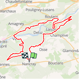
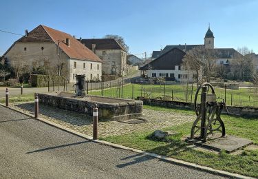
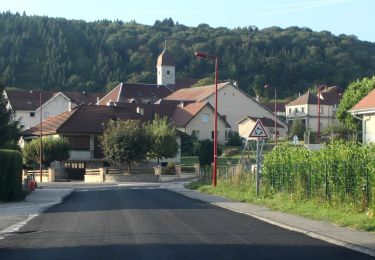
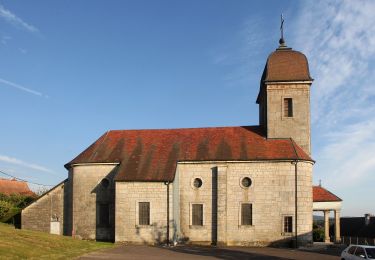
Tocht Mountainbike van 43 km beschikbaar op Bourgondië-Franche-Comté, Doubs, Nancray. Deze tocht wordt voorgesteld door tracegps.

Beschrijving

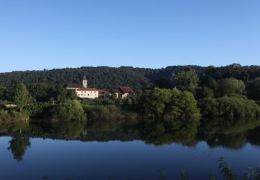
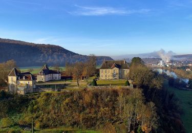
Ce parcours est de niveau très difficile. Le départ permet de se chauffer doucement grâce a un chemin en goudron pendant 3 km. Nous entrons ensuite dans les bois pour une série de singles jusqu'aux villages de Vaire le Grand et Vaire le Petit. S'en suit une montée de 200m de dénivelé jusqu'à la chapelle de Notre dame d'Aigremont. On redescend en passant par Roulans et Laissey en empruntant un peu de route goudronnée. A partir d'ici, nous attend. LA montée. Dénivelé de 300m sur 3km. En haut, la vue depuis le Rocher du Rechandet est..... magnifique. J’ai rarement vu un si beau panorama !!! Le retour sur Nancray alterne petites montées, descentes techniques et chemins plus ou moins cassant pour les jambes... Ce parcours est extrêmement varié. Vraiment bien !!

Hoogteprofiel

Foto's

Plaatsbepaling

Land:
France
Regio :
Bourgondië-Franche-Comté
Departement/Provincie :
Doubs
Gemeente :
Nancray
Locatie:
Unknown
Vertrek:(Dec)
Vertrek:(UTM)
286757 ; 5236463 (32T) N.

Wandeltochten in de omgeving

Tocht Te voet Nancray - Circuit du Chêne Président - Photo
Te voet
PRO

Te voet

Gemakkelijk
Nancray, Bourgondië-Franche-Comté, Doubs, France
6,4 km | 7,2 km-effort
1h 38min
Ja
Tocht Te voet Saône - Sentier des Essarts - Photo
Te voet
PRO

Te voet

Gemakkelijk
Saône, Bourgondië-Franche-Comté, Doubs, France
6,9 km | 8,1 km-effort
1h 50min
Ja
Tocht Te voet Nancray - Sentier du Fonteny - Photo
Te voet
PRO

Te voet

Gemakkelijk
Nancray, Bourgondië-Franche-Comté, Doubs, France
7,4 km | 9 km-effort
2h 2min
Ja
Tocht Te voet Mamirolle - Sentier du Golf - Photo
Te voet
PRO

Te voet

Gemakkelijk
Mamirolle, Bourgondië-Franche-Comté, Doubs, France
8,7 km | 10,4 km-effort
2h 21min
Ja
Tocht Te voet Nancray - Sentier du Moulin - Photo
Te voet
PRO

Te voet

Gemakkelijk
Nancray, Bourgondië-Franche-Comté, Doubs, France
9,5 km | 12,5 km-effort
2h 50min
Ja
Tocht Te voet Nancray - Sentier du Tour des Landes - Photo
Te voet
PRO

Te voet

Gemakkelijk
Nancray, Bourgondië-Franche-Comté, Doubs, France
8 km | 10,4 km-effort
2h 22min
Ja
Tocht Te voet Gennes - Sentier du Fort des Epesses - Photo
Te voet
PRO

Te voet

Gemakkelijk
Gennes, Bourgondië-Franche-Comté, Doubs, France
10,4 km | 14,4 km-effort
3h 16min
Ja
Tocht Te voet Vaire - Sentier des Sources 2 - Photo
Te voet
PRO

Te voet

Gemakkelijk
Vaire, Bourgondië-Franche-Comté, Doubs, France
4,9 km | 6,7 km-effort
1h 30min
Ja
Tocht Te voet Vaire - Sentier des Sources 1 - Photo
Te voet
PRO

Te voet

Gemakkelijk
Vaire, Bourgondië-Franche-Comté, Doubs, France
7,6 km | 10,9 km-effort
2h 29min
Ja


Sluiten
Mijn abonnementen