Tocht Stappen Rieupeyroux - Rieupeyroux - Prévinquière - Photo

Rieupeyroux - Prévinquière

 tracegps
tracegps

Gebruiker

© OpenStreetMap contributors
Lengte
Lengte
23 km
Max. hoogte
Max. hoogte
784 m
Positief hoogteverschil
666 m
Km-Effort
Km-Effort  
32 km
Min. hoogte
Min. hoogte
380 m
Negatief hoogteverschil
666 m
Boucle
Boucle
Ja
Datum van aanmaak :
2014-12-10 00:00:00.0
Laatste wijziging :
2014-12-10 00:00:00.0

(0 Bericht)

Stappen
Stappen
7h00
Moeilijkheid : Moeilijk

Scan deze QR-code om de tocht te openen in de SityTrail-applicatie

Gratisgps-wandelapplicatie

Logo SityTrail SityTrail

IGN / Geografische instituten

SityTrail uit de App Store downloaden SityTrail uit Google Play downloaden

Logo SityTrail SityTrail World

De wereld gaat voor u open

SityTrail uit de App Store downloaden SityTrail uit Google Play downloaden SityTrail op Huawei AppGallery downloaden

Over ons

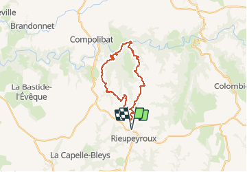
Tocht Stappen van 23 km beschikbaar op Occitanië, Aveyron, Rieupeyroux. Deze tocht wordt voorgesteld door tracegps.

Beschrijving

Ce circuit relie Rieupeyroux à Prévinquière, sur la même commune, au fond de la vallée de l'Aveyron. C'est le plus long et difficile circuit proposé et balisé par le syndicat d'initiative de Rieupeyroux où on peut en acheter le guide. En VTT la remontée se fait sur un chemin relativement large mais extrêmement raide qui nécessite de pousser le vélo plusieurs fois sur les premiers 500m de la remontée.

Hoogteprofiel

Plaatsbepaling

Land:
France
Regio :
Occitanië
Departement/Provincie :
Aveyron
Gemeente :
Rieupeyroux
Locatie:
Unknown
Vertrek:(Dec)
Vertrek:(UTM)
439005 ; 4906912 (31T) N.

Wandeltochten in de omgeving

Tocht Te voet La Capelle-Bleys - La Capelle Bleys - Photo
Te voet
BESSOU1294

Te voet

Gemakkelijk
(1)
La Capelle-Bleys, Occitanië, Aveyron, France
9,8 km | 12,8 km-effort
2h 45min
Ja
Tocht Fiets Rieupeyroux - Le Ségala, le Pays des 100 vallées - Rieupeyroux - Photo
Fiets
tracegps

Fiets

Moeilijk
Rieupeyroux, Occitanië, Aveyron, France
71 km | 87 km-effort
4h 30min
Ja
Tocht Stappen Rieupeyroux - Rando Occitane  - Photo
Stappen
brigittedelasource

Stappen

Heel gemakkelijk
Rieupeyroux, Occitanië, Aveyron, France
9,8 km | 13,2 km-effort
2h 54min
Neen
Tocht Stappen Rieupeyroux - Tour du Pradal - Photo
Stappen
Benoît Marquès

Stappen

Gemakkelijk
Rieupeyroux, Occitanië, Aveyron, France
3,9 km | 5,8 km-effort
1h 32min
Ja
Tocht Auto Rieupeyroux - negrefoylt 12 - Photo
Auto
saegaert

Auto

Heel gemakkelijk
Rieupeyroux, Occitanië, Aveyron, France
54 km | 70 km-effort
3h 0min
Neen
Tocht Mountainbike Rieupeyroux - Rieupeyroux - Prévinquière - Photo
Mountainbike
tracegps

Mountainbike

Moeilijk
Rieupeyroux, Occitanië, Aveyron, France
23 km | 32 km-effort
2h 45min
Ja
Tocht Trail Rieupeyroux - Balade vues sur les plateaux - Photo
Trail
Benoît Marquès

Trail

Medium
Rieupeyroux, Occitanië, Aveyron, France
6,3 km | 9 km-effort
1h 0min
Neen
Tocht Stappen Rieupeyroux - rieupeyroux - Photo
Stappen
Bernardroland

Stappen

Medium
Rieupeyroux, Occitanië, Aveyron, France
12,3 km | 16,4 km-effort
3h 17min
Ja


Sluiten
Mijn abonnementen