Tocht Stappen Plan-d'Aups-Sainte-Baume - Plan d'Aups Sainte Baume - Pic de Bertagne - Photo

Plan d'Aups Sainte Baume - Pic de Bertagne

 tracegps
tracegps

Gebruiker

© OpenStreetMap contributors
Lengte
Lengte
10,1 km
Max. hoogte
Max. hoogte
1032 m
Positief hoogteverschil
439 m
Km-Effort
Km-Effort  
15,9 km
Min. hoogte
Min. hoogte
696 m
Negatief hoogteverschil
440 m
Boucle
Boucle
Ja
Datum van aanmaak :
2014-12-10 00:00:00.0
Laatste wijziging :
2014-12-10 00:00:00.0

(0 Bericht)

Stappen
Stappen
3h30
Moeilijkheid : Moeilijk

Scan deze QR-code om de tocht te openen in de SityTrail-applicatie

Gratisgps-wandelapplicatie

Logo SityTrail SityTrail

IGN / Geografische instituten

SityTrail uit de App Store downloaden SityTrail uit Google Play downloaden

Logo SityTrail SityTrail World

De wereld gaat voor u open

SityTrail uit de App Store downloaden SityTrail uit Google Play downloaden SityTrail op Huawei AppGallery downloaden

Over ons

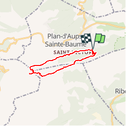
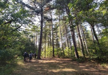
Tocht Stappen van 10,1 km beschikbaar op Provence-Alpes-Côte d'Azur, Var, Plan-d'Aups-Sainte-Baume. Deze tocht wordt voorgesteld door tracegps.

Beschrijving

Niveau de difficulté 4. Belle randonnée dans le massif de la sainte Baume avec de beaux points de vue. Le Pic de Bertagne avec ses 1042 m est le point culminant des Bouches du Rhône.

Hoogteprofiel

Foto's

Plaatsbepaling

Land:
France
Regio :
Provence-Alpes-Côte d'Azur
Departement/Provincie :
Var
Gemeente :
Plan-d'Aups-Sainte-Baume
Locatie:
Unknown
Vertrek:(Dec)
Vertrek:(UTM)
721639 ; 4800480 (31T) N.

Wandeltochten in de omgeving

Tocht Stappen Plan-d'Aups-Sainte-Baume - Sainte Baume 8,5 km - Photo
Stappen
GUIDE
rvapeldo

Stappen

Medium
(1)
Plan-d'Aups-Sainte-Baume, Provence-Alpes-Côte d'Azur, Var, France
8,4 km | 15,5 km-effort
4h 38min
Ja
Tocht Stappen Plan-d'Aups-Sainte-Baume - SityTrail - Sentier merveilleux - La Ste baume - Le Plan d'aups  - Photo
Stappen
GUIDE
affinetataille

Stappen

Medium
(1)
Plan-d'Aups-Sainte-Baume, Provence-Alpes-Côte d'Azur, Var, France
15 km | 23 km-effort
6h 0min
Ja
Tocht Stappen Plan-d'Aups-Sainte-Baume - Crêts de la Ste Baume - Photo
Stappen
tracegps

Stappen

Medium
(2)
Plan-d'Aups-Sainte-Baume, Provence-Alpes-Côte d'Azur, Var, France
15,4 km | 23 km-effort
5h 0min
Ja
Tocht Stappen Plan-d'Aups-Sainte-Baume - Du Col du Saint-Pilon au Pas de l'Aï, Sainte Baume - Photo
Stappen
tracegps

Stappen

Medium
(1)
Plan-d'Aups-Sainte-Baume, Provence-Alpes-Côte d'Azur, Var, France
13,1 km | 20 km-effort
5h 15min
Ja
Tocht Stappen Riboux - Riboux - Forêt de Malaucène - Photo
Stappen
tracegps

Stappen

Medium
(4)
Riboux, Provence-Alpes-Côte d'Azur, Var, France
12,2 km | 15,2 km-effort
2h 40min
Ja
Tocht Stappen Plan-d'Aups-Sainte-Baume - La Grotte aux oiseaux - Plan d'Aups  - Photo
Stappen
tracegps

Stappen

Medium
(1)
Plan-d'Aups-Sainte-Baume, Provence-Alpes-Côte d'Azur, Var, France
8,8 km | 12,5 km-effort
2h 30min
Ja
Tocht Te voet Plan-d'Aups-Sainte-Baume - Massif Sainte Baume et pas de l’Aï 15 km - Photo
Te voet
GUIDE
rvapeldo

Te voet

Medium
Plan-d'Aups-Sainte-Baume, Provence-Alpes-Côte d'Azur, Var, France
15 km | 22 km-effort
5h 0min
Ja
Tocht Stappen Plan-d'Aups-Sainte-Baume - Pic de Bertagne - Grotte Betton - Le plan d'aups - Photo
Stappen
GUIDE
affinetataille

Stappen

Medium
Plan-d'Aups-Sainte-Baume, Provence-Alpes-Côte d'Azur, Var, France
9,9 km | 15,7 km-effort
3h 30min
Ja
Tocht Stappen Plan-d'Aups-Sainte-Baume - Sentier merveilleux - La Ste baume - Le Plan d'aups  - Photo
Stappen
GUIDE
affinetataille

Stappen

Gemakkelijk
Plan-d'Aups-Sainte-Baume, Provence-Alpes-Côte d'Azur, Var, France
11,4 km | 15,3 km-effort
4h 0min
Ja


Sluiten
Mijn abonnementen