Tocht Stappen Montsalès - Montsales Villeneuve - Photo

Montsales Villeneuve

 Gerard_Soulie
Gerard_Soulie

Gebruiker

© OpenStreetMap contributors
Lengte
Lengte
10,5 km
Max. hoogte
Max. hoogte
399 m
Positief hoogteverschil
175 m
Km-Effort
Km-Effort  
12,7 km
Min. hoogte
Min. hoogte
302 m
Negatief hoogteverschil
119 m
Boucle
Boucle
Neen
Datum van aanmaak :
2019-01-15 20:08:49.757
Laatste wijziging :
2019-01-15 20:08:49.757

(0 Bericht)

Stappen
Stappen
2h46
Moeilijkheid : Heel gemakkelijk

Scan deze QR-code om de tocht te openen in de SityTrail-applicatie

Gratisgps-wandelapplicatie

Logo SityTrail SityTrail

IGN / Geografische instituten

SityTrail uit de App Store downloaden SityTrail uit Google Play downloaden

Logo SityTrail SityTrail World

De wereld gaat voor u open

SityTrail uit de App Store downloaden SityTrail uit Google Play downloaden SityTrail op Huawei AppGallery downloaden

Over ons

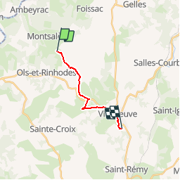
Tocht Stappen van 10,5 km beschikbaar op Occitanië, Aveyron, Montsalès. Deze tocht wordt voorgesteld door Gerard_Soulie.

Beschrijving

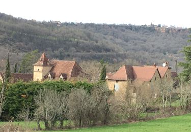
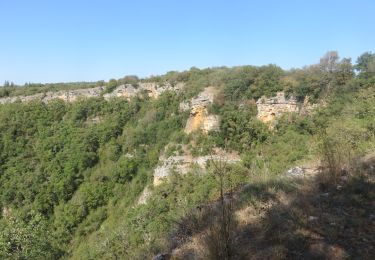
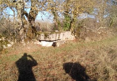
De Montsalés à Villeneuve par les roseaux et Caussanels

Hoogteprofiel

Plaatsbepaling

Land:
France
Regio :
Occitanië
Departement/Provincie :
Aveyron
Gemeente :
Montsalès
Locatie:
Unknown
Vertrek:(Dec)
Vertrek:(UTM)
418245 ; 4925779 (31T) N.

Wandeltochten in de omgeving

Tocht Mountainbike Montsalès - VTT boucle  Montsalès - Mas du Causse - Balaguier d'Olt - Photo
Mountainbike
Levillefranchois

Mountainbike

Medium
Montsalès, Occitanië, Aveyron, France
21 km | 28 km-effort
2h 48min
Ja
Tocht Mountainbike Montsalès - VTT Le Mas du Causse - Photo
Mountainbike
Levillefranchois

Mountainbike

Gemakkelijk
Montsalès, Occitanië, Aveyron, France
21 km | 28 km-effort
1h 55min
Ja
Tocht Stappen Larroque-Toirac - Larroque -Toirac -mas del Suc  - Photo
Stappen
houbart

Stappen

Moeilijk
Larroque-Toirac, Occitanië, Lot, France
10,8 km | 16,2 km-effort
3h 40min
Ja
Tocht Stappen Foissac - foissac montsalès - Photo
Stappen
faycellesgrandvaltin

Stappen

Heel gemakkelijk
Foissac, Occitanië, Aveyron, France
13,3 km | 17,8 km-effort
3h 48min
Ja
Tocht Mountainbike La Capelle-Balaguier - la capelle maroule puyjourdes loule anglars les buis lacapelle - Photo
Mountainbike
Gerard_Soulie

Mountainbike

Medium
La Capelle-Balaguier, Occitanië, Aveyron, France
31 km | 40 km-effort
2h 52min
Ja
Tocht Mountainbike La Capelle-Balaguier - la capelle anglars estrabols borieangle croix belge saut mounine trep et retour lac - Photo
Mountainbike
Gerard_Soulie

Mountainbike

Medium
La Capelle-Balaguier, Occitanië, Aveyron, France
32 km | 40 km-effort
3h 8min
Ja
Tocht Stappen La Capelle-Balaguier - Boucle de Lacapelle Balaguier - Photo
Stappen
tracegps

Stappen

Medium
La Capelle-Balaguier, Occitanië, Aveyron, France
14 km | 18,4 km-effort
3h 0min
Ja
Tocht Mountainbike Montsalès - VTT Montsalès Mounine Ols 21km  2024-01-30 - Photo
Mountainbike
Levillefranchois

Mountainbike

Gemakkelijk
Montsalès, Occitanië, Aveyron, France
20 km | 24 km-effort
1h 41min
Ja
Tocht Mountainbike Montsalès - VTT Mntsls Vernet Croix des Belges 40km 1000D+  04 JUIL 2023 Frantz Vincent Mag. - Photo
Mountainbike
Levillefranchois

Mountainbike

Moeilijk
Montsalès, Occitanië, Aveyron, France
39 km | 52 km-effort
3h 36min
Ja


Sluiten
Mijn abonnementen