Tocht Stappen Mesnil-en-Ouche - Circuit de pierre ronde - Beaumesnil - Photo

Circuit de pierre ronde - Beaumesnil

 tracegps
tracegps

Gebruiker

© OpenStreetMap contributors
Lengte
Lengte
11 km
Max. hoogte
Max. hoogte
174 m
Positief hoogteverschil
123 m
Km-Effort
Km-Effort  
12,7 km
Min. hoogte
Min. hoogte
129 m
Negatief hoogteverschil
123 m
Boucle
Boucle
Ja
Datum van aanmaak :
2014-12-10 00:00:00.0
Laatste wijziging :
2014-12-10 00:00:00.0

(0 Bericht)

Stappen
Stappen
2h45
Moeilijkheid : Medium

Scan deze QR-code om de tocht te openen in de SityTrail-applicatie

Gratisgps-wandelapplicatie

Logo SityTrail SityTrail

IGN / Geografische instituten

SityTrail uit de App Store downloaden SityTrail uit Google Play downloaden

Logo SityTrail SityTrail World

De wereld gaat voor u open

SityTrail uit de App Store downloaden SityTrail uit Google Play downloaden SityTrail op Huawei AppGallery downloaden

Over ons

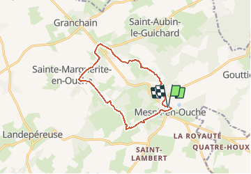
Tocht Stappen van 11 km beschikbaar op Normandië, Eure, Mesnil-en-Ouche. Deze tocht wordt voorgesteld door tracegps.

Beschrijving

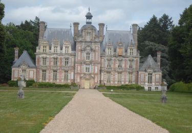
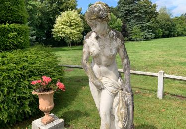
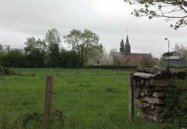
Circuit proposé par la Communauté de Communes du canton de Beaumesnil et l’Office de Tourisme de Beaumesnil. Départ du parking de la Communauté de commune du canton de Beaumesnil (3CB) Découvrez au départ du circuit le château de Beaumesnil dit "Le Mesnil Royal", remarquable monument baroque classé monument historique, qui vous invite à découvrir son intérieur meublé et sa collection de reliures anciennes avant de vous promener dans son parc de 60 hectares et ses jardins à la française. Retrouvez ce circuit, parmi 17 autres, sur le dépliant proposé par l’office de Tourisme.

Hoogteprofiel

Foto's

Plaatsbepaling

Land:
France
Regio :
Normandië
Departement/Provincie :
Eure
Gemeente :
Mesnil-en-Ouche
Locatie:
Unknown
Vertrek:(Dec)
Vertrek:(UTM)
332257 ; 5431455 (31U) N.

Wandeltochten in de omgeving

Tocht Stappen Le Noyer-en-Ouche - Circuit de Chatel La Lune - Le Noyer en Ouche - Photo
Stappen
tracegps

Stappen

Medium
(1)
Le Noyer-en-Ouche, Normandië, Eure, France
10,3 km | 11,9 km-effort
2h 30min
Ja
Tocht Stappen Mesnil-en-Ouche - Circuit des vallons d'Epinay  - Photo
Stappen
tracegps

Stappen

Medium
(2)
Mesnil-en-Ouche, Normandië, Eure, France
11,1 km | 12,7 km-effort
2h 45min
Ja
Tocht Stappen Le Noyer-en-Ouche - Le noyer en ouche - Mancelles - Photo
Stappen
serleb

Stappen

Gemakkelijk
Le Noyer-en-Ouche, Normandië, Eure, France
10,3 km | 11,8 km-effort
2h 45min
Ja
Tocht Stappen Mesnil-en-Ouche - 20220610-Beaumesnil - Photo
Stappen
doudet

Stappen

Medium
Mesnil-en-Ouche, Normandië, Eure, France
22 km | 24 km-effort
5h 57min
Ja
Tocht Wegfiets Mesnil-en-Ouche - BeauMESNIL  - Photo
Wegfiets
jpbonnemains

Wegfiets

Mesnil-en-Ouche, Normandië, Eure, France
27 km | 0 m-effort
1h 33min
Neen
Tocht Mountainbike Mesnil-en-Ouche - Circuit de la Petite Chouquetiére - Grandchain - Photo
Mountainbike
tracegps

Mountainbike

Gemakkelijk
Mesnil-en-Ouche, Normandië, Eure, France
7,3 km | 7,8 km-effort
1h 0min
Ja
Tocht Stappen Mesnil-en-Ouche - Circuit de la Petite Chouquetiére - Grandchain - Photo
Stappen
tracegps

Stappen

Gemakkelijk
Mesnil-en-Ouche, Normandië, Eure, France
7,3 km | 7,8 km-effort
1h 49min
Ja
Tocht Mountainbike Mesnil-en-Ouche - Circuit des Bouleaux - Ste Marguerite en Ouche - Photo
Mountainbike
tracegps

Mountainbike

Gemakkelijk
Mesnil-en-Ouche, Normandië, Eure, France
7,8 km | 8,4 km-effort
1h 0min
Ja
Tocht Stappen Mesnil-en-Ouche - Circuit des Bouleaux - Ste Marguerite en Ouche - Photo
Stappen
tracegps

Stappen

Gemakkelijk
Mesnil-en-Ouche, Normandië, Eure, France
7,8 km | 8,4 km-effort
1h 55min
Ja


Sluiten
Mijn abonnementen