Tocht Stappen Chamblac - Circuit de Bonneville  -  Chamblac - Photo

Circuit de Bonneville - Chamblac

 tracegps
tracegps

Gebruiker

© OpenStreetMap contributors
Lengte
Lengte
11,2 km
Max. hoogte
Max. hoogte
201 m
Positief hoogteverschil
61 m
Km-Effort
Km-Effort  
12 km
Min. hoogte
Min. hoogte
182 m
Negatief hoogteverschil
61 m
Boucle
Boucle
Ja
Datum van aanmaak :
2014-12-10 00:00:00.0
Laatste wijziging :
2014-12-10 00:00:00.0

(0 Bericht)

Stappen
Stappen
2h45
Moeilijkheid : Medium

Scan deze QR-code om de tocht te openen in de SityTrail-applicatie

Gratisgps-wandelapplicatie

Logo SityTrail SityTrail

IGN / Geografische instituten

SityTrail uit de App Store downloaden SityTrail uit Google Play downloaden

Logo SityTrail SityTrail World

De wereld gaat voor u open

SityTrail uit de App Store downloaden SityTrail uit Google Play downloaden SityTrail op Huawei AppGallery downloaden

Over ons

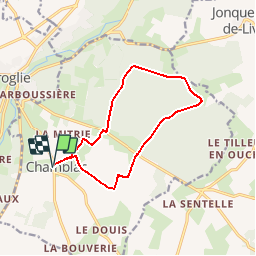
Tocht Stappen van 11,2 km beschikbaar op Normandië, Eure, Chamblac. Deze tocht wordt voorgesteld door tracegps.

Beschrijving

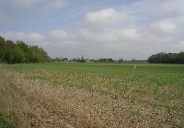
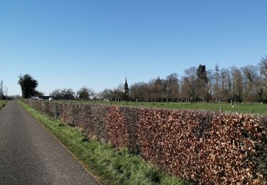
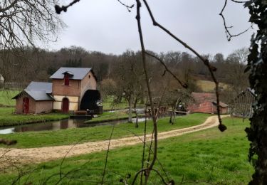
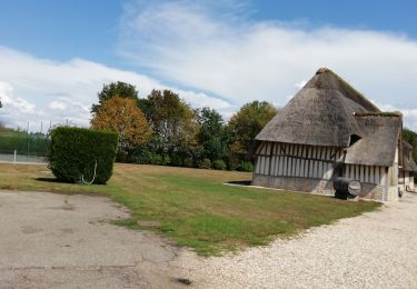
Circuit proposé par la Communauté de Communes du canton de Broglie. Départ de la mairie de Chamblac. A découvrir : l’église Notre-Dame 16e siécle, château de Bonneville, forêt de Broglie, la Pierre l’Ormée, le chemin Perrey (ancienne voie romaine). Ce circuit a été numérisé par les randonneurs du CODEPEM. Merci à Jean-Marie.

Hoogteprofiel

Foto's

Plaatsbepaling

Land:
France
Regio :
Normandië
Departement/Provincie :
Eure
Gemeente :
Chamblac
Locatie:
Unknown
Vertrek:(Dec)
Vertrek:(UTM)
320302 ; 5429067 (31U) N.

Wandeltochten in de omgeving

Tocht Stappen Ferrières-Saint-Hilaire - Ferrières St Hilaire - Photo
Stappen
FROIDMONT

Stappen

Heel gemakkelijk
(1)
Ferrières-Saint-Hilaire, Normandië, Eure, France
9,4 km | 11,3 km-effort
2h 25min
Ja
Tocht Fiets Broglie - Boucle des 3 Maréchaux  -  Broglie - Photo
Fiets
tracegps

Fiets

Medium
Broglie, Normandië, Eure, France
18,5 km | 20 km-effort
1h 15min
Ja
Tocht Stappen Broglie - Circuit du Prieuré - Broglie - Photo
Stappen
tracegps

Stappen

Moeilijk
(1)
Broglie, Normandië, Eure, France
13,2 km | 14,9 km-effort
3h 19min
Ja
Tocht Mountainbike Mesnil-en-Ouche - Circuit du Bois des Hautcaires - Jonquerets de Livet - Photo
Mountainbike
tracegps

Mountainbike

Medium
Mesnil-en-Ouche, Normandië, Eure, France
8,5 km | 9,2 km-effort
1h 10min
Ja
Tocht Stappen Mesnil-en-Ouche - Circuit du Bois des Hautcaires - Jonquerets de Livet - Photo
Stappen
tracegps

Stappen

Medium
(1)
Mesnil-en-Ouche, Normandië, Eure, France
8,5 km | 9,2 km-effort
2h 4min
Ja
Tocht Stappen Saint-Aubin-du-Thenney - boucle de St Aubin  - Photo
Stappen
ymarvin

Stappen

Gemakkelijk
Saint-Aubin-du-Thenney, Normandië, Eure, France
5,2 km | 5,7 km-effort
1h 1min
Ja
Tocht Stappen Chamblac - Le Chamblac - Photo
Stappen
ymarvin

Stappen

Gemakkelijk
Chamblac, Normandië, Eure, France
9,1 km | 9,7 km-effort
1h 52min
Ja
Tocht Stappen Broglie - Broglie - Photo
Stappen
werth

Stappen

Medium
Broglie, Normandië, Eure, France
10,1 km | 11,8 km-effort
2h 50min
Ja
Tocht Stappen Mesnil-en-Ouche - Les jonquerets de livet - Photo
Stappen
ymarvin

Stappen

Heel gemakkelijk
Mesnil-en-Ouche, Normandië, Eure, France
8,9 km | 9,6 km-effort
1h 46min
Ja


Sluiten
Mijn abonnementen