Tocht Stappen Calonges - Calonges, balade dans la plaine de la Garonne - Pays Val de Garonne - Gascogne - Photo

Calonges, balade dans la plaine de la Garonne - Pays Val de Garonne - Gascogne

 tracegps
tracegps

Gebruiker

© OpenStreetMap contributors
Lengte
Lengte
11,8 km
Max. hoogte
Max. hoogte
48 m
Positief hoogteverschil
117 m
Km-Effort
Km-Effort  
13,4 km
Min. hoogte
Min. hoogte
26 m
Negatief hoogteverschil
119 m
Boucle
Boucle
Ja
Datum van aanmaak :
2014-12-10 00:00:00.0
Laatste wijziging :
2014-12-10 00:00:00.0

(0 Bericht)

Stappen
Stappen
3h15
Moeilijkheid : Medium

Scan deze QR-code om de tocht te openen in de SityTrail-applicatie

Gratisgps-wandelapplicatie

Logo SityTrail SityTrail

IGN / Geografische instituten

SityTrail uit de App Store downloaden SityTrail uit Google Play downloaden

Logo SityTrail SityTrail World

De wereld gaat voor u open

SityTrail uit de App Store downloaden SityTrail uit Google Play downloaden SityTrail op Huawei AppGallery downloaden

Over ons

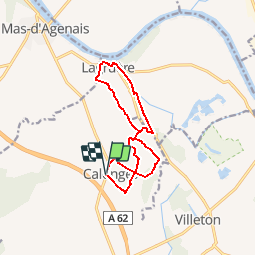
Tocht Stappen van 11,8 km beschikbaar op Nieuw-Aquitanië, Lot-et-Garonne, Calonges. Deze tocht wordt voorgesteld door tracegps.

Beschrijving

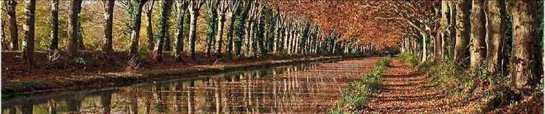
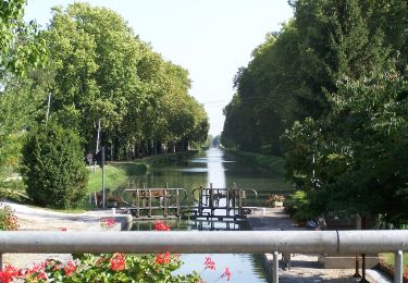
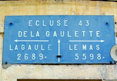
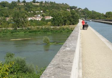
Calonges Communauté de Communes Val de Garonne. Cette randonnée sans difficulté vous fera découvrir les nombreux séchoirs à tabac, témoins d’un passé récent ou l’herbe à Nicot prospérait et les bords ombragés de la voie verte du canal de Garonne. Téléchargez la fiche de cette randonnée sur le site du Tourisme du Lot et Garonne.

Hoogteprofiel

Foto's

Plaatsbepaling

Land:
France
Regio :
Nieuw-Aquitanië
Departement/Provincie :
Lot-et-Garonne
Gemeente :
Calonges
Locatie:
Unknown
Vertrek:(Dec)
Vertrek:(UTM)
280193 ; 4917127 (31T) N.

Wandeltochten in de omgeving

Tocht Te voet Puch-d'Agenais - Puch-d’Agenais, dans les terrasses de Garonne - 6.2km - Photo
Te voet
PRO

Te voet

Gemakkelijk
Puch-d'Agenais, Nieuw-Aquitanië, Lot-et-Garonne, France
6,1 km | 7 km-effort
1h 35min
Ja
Tocht Te voet Le Mas-d'Agenais - Le Mas-d'Agenais, du canal à la forêt - 12.8 km - Photo
Te voet
PRO

Te voet

Gemakkelijk
Le Mas-d'Agenais, Nieuw-Aquitanië, Lot-et-Garonne, France
12,7 km | 14,6 km-effort
3h 19min
Ja
Tocht Te voet Lagruère - Lagruère, dans la boucle de l'Ourbise - 10.6 km - Photo
Te voet
PRO

Te voet

Gemakkelijk
Lagruère, Nieuw-Aquitanië, Lot-et-Garonne, France
10,5 km | 11,6 km-effort
2h 37min
Ja
Tocht Te voet Calonges - Calonges, balade dans la plaine de la Garonne - 11.8 km - Photo
Te voet
PRO

Te voet

Gemakkelijk
Calonges, Nieuw-Aquitanië, Lot-et-Garonne, France
4,2 km | 4,6 km-effort
1h 3min
Neen
Tocht Fietstoerisme Le Mas-d'Agenais - Mas d'Agenais-Agen - Photo
Fietstoerisme
ilur56

Fietstoerisme

Medium
Le Mas-d'Agenais, Nieuw-Aquitanië, Lot-et-Garonne, France
52 km | 58 km-effort
Onbekend
Neen
Tocht Te voet Monheurt - Monheurt, balade entre Garonne et canal - 7 km - Photo
Te voet
PRO

Te voet

Gemakkelijk
Monheurt, Nieuw-Aquitanië, Lot-et-Garonne, France
6,8 km | 7,5 km-effort
1h 41min
Ja
Tocht Te voet Le Mas-d'Agenais - Le Mas-d'Agenais - Les princes des sous-bois en forêt du Mas (Variante) - 5.4 km - Photo
Te voet
PRO

Te voet

Gemakkelijk
Le Mas-d'Agenais, Nieuw-Aquitanië, Lot-et-Garonne, France
5,4 km | 6 km-effort
1h 22min
Ja
Tocht Te voet Le Mas-d'Agenais - Le Mas-d'Agenais - Les princes des sous-bois en forêt du Mas - 7 km - Photo
Te voet
PRO

Te voet

Gemakkelijk
Le Mas-d'Agenais, Nieuw-Aquitanië, Lot-et-Garonne, France
7 km | 7,8 km-effort
1h 46min
Ja
Tocht Te voet Lagruère - Lagruère, promenade sur les berges de Garonne - 9.8 km - Photo
Te voet
PRO

Te voet

Gemakkelijk
Lagruère, Nieuw-Aquitanië, Lot-et-Garonne, France
9,7 km | 10,9 km-effort
2h 28min
Ja


Sluiten
Mijn abonnementen