Tocht Lopen Orthez - Géocaching Laqueyre - Photo
 tracegps
tracegps

Gebruiker

© OpenStreetMap contributors
Lengte
Lengte
10,8 km
Max. hoogte
Max. hoogte
177 m
Positief hoogteverschil
215 m
Km-Effort
Km-Effort  
13,6 km
Min. hoogte
Min. hoogte
70 m
Negatief hoogteverschil
215 m
Boucle
Boucle
Ja
Datum van aanmaak :
2014-12-10 00:00:00.0
Laatste wijziging :
2014-12-10 00:00:00.0

(0 Bericht)

Lopen
Lopen
1h30
Moeilijkheid : Moeilijk

Scan deze QR-code om de tocht te openen in de SityTrail-applicatie

Gratisgps-wandelapplicatie

Logo SityTrail SityTrail

IGN / Geografische instituten

SityTrail uit de App Store downloaden SityTrail uit Google Play downloaden

Logo SityTrail SityTrail World

De wereld gaat voor u open

SityTrail uit de App Store downloaden SityTrail uit Google Play downloaden SityTrail op Huawei AppGallery downloaden

Over ons

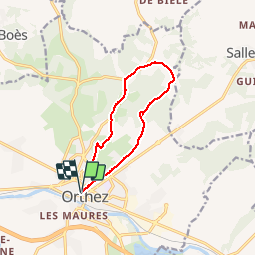
Tocht Lopen van 10,8 km beschikbaar op Nieuw-Aquitanië, Pyrénées-Atlantiques, Orthez. Deze tocht wordt voorgesteld door tracegps.

Beschrijving

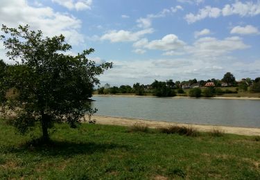
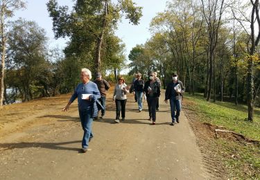
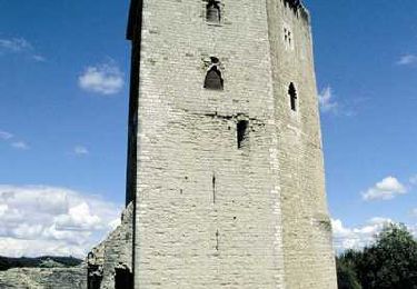
Ce circuit part de l'office de tourisme d'Orthez - Maison Jeanne d'Albret. Il monte vers la tour Moncade en longeant de nombreuses maisons anciennes. Puis il part à travers champs et à travers bois pour rejoindre le Chemin de Saint jacques de Compostelle : voie de Vézelay pour retourner à Orthez. Ce circuit propose un belvédère dans le bois de Laqueyre avec possibilité de très jolis panoramas sur la chaîne des Pyrénées et la vielle ville d'Orthez. Une cache de geocaching est installée sur ce parcours.

Hoogteprofiel

Foto's

Plaatsbepaling

Land:
France
Regio :
Nieuw-Aquitanië
Departement/Provincie :
Pyrénées-Atlantiques
Gemeente :
Orthez
Locatie:
Unknown
Vertrek:(Dec)
Vertrek:(UTM)
679931 ; 4817453 (30T) N.

Wandeltochten in de omgeving

Tocht Stappen Orthez - ORTHEZ  GRvP 29 02 2024 - Photo
Stappen
GUIDE
marmotte65

Stappen

Moeilijk
Orthez, Nieuw-Aquitanië, Pyrénées-Atlantiques, France
14,4 km | 17,2 km-effort
5h 39min
Neen
Tocht Te voet Orthez - PARI 2024 Orthez / Sault de Navailles
Te voet
GUIDE
marmotte65

Te voet

Gemakkelijk
Orthez, Nieuw-Aquitanië, Pyrénées-Atlantiques, France
14,4 km | 17,2 km-effort
3h 54min
Neen
Tocht Stappen Orthez - ORTHEZ Medieval (CCLO) G4 labélisation fait  - Photo
Stappen
GUIDE
marmotte65

Stappen

Gemakkelijk
Orthez, Nieuw-Aquitanië, Pyrénées-Atlantiques, France
6 km | 7,6 km-effort
1h 53min
Ja
Tocht Stappen Orthez - ORTHEZ Laqueyre M1 et M2  le 14/12/2022
Stappen
GUIDE
marmotte65

Stappen

Moeilijk
Orthez, Nieuw-Aquitanië, Pyrénées-Atlantiques, France
9,9 km | 12,2 km-effort
4h 46min
Ja
Tocht Stappen Orthez - ORTHEZ Lac de Biron - Photo
Stappen
GUIDE
marmotte65

Stappen

Heel gemakkelijk
Orthez, Nieuw-Aquitanië, Pyrénées-Atlantiques, France
3,5 km | 3,8 km-effort
1h 16min
Neen
Tocht Mountainbike Orthez - Géocaching Laqueyre - Photo
Mountainbike
tracegps

Mountainbike

Medium
Orthez, Nieuw-Aquitanië, Pyrénées-Atlantiques, France
10,8 km | 13,6 km-effort
1h 0min
Ja
Tocht Stappen Orthez - Géocaching Laqueyre - Photo
Stappen
tracegps

Stappen

Medium
Orthez, Nieuw-Aquitanië, Pyrénées-Atlantiques, France
10,8 km | 13,6 km-effort
3h 0min
Ja
Tocht Stappen Orthez - Orthez - Laqueyre - Photo
Stappen
tracegps

Stappen

Medium
Orthez, Nieuw-Aquitanië, Pyrénées-Atlantiques, France
9,5 km | 11,6 km-effort
3h 0min
Ja
Tocht Te voet Orthez - SityTrail - Orthez Médiéval - Photo
Te voet
GUIDE
marmotte65

Te voet

Gemakkelijk
Orthez, Nieuw-Aquitanië, Pyrénées-Atlantiques, France
5,8 km | 7,5 km-effort
1h 41min
Ja


Sluiten
Mijn abonnementen