![](/images/other/stat-length.png)
![Tocht Fiets Villeréal - Circuit de la Bastide Royale - Villeréal - Pays du Dropt - Photo](https://media.geolcdn.com/t/1900/400/ext.pjpeg?maxdim=2&url=https%3A%2F%2Fservices.sitytrail.com%2FGeolivesWS%2FDownloadMedia.ashx%3FTrailID%3D111808%26Media%3D8395_2.jpg)
Circuit de la Bastide Royale - Villeréal - Pays du Dropt
tracegps
Gebruiker
![Lengte](/images/other/stat-length.png)
![Max. hoogte](https://static1.geolcdn.com/siteimages/upload/files/1508320355ic_sort_altitude_max_24dp.png)
![Positief hoogteverschil](https://static1.geolcdn.com/siteimages/upload/files/1508320355ic_sort_den_pos_24dp.png)
![Km-Effort](/images/other/stat-length.png)
![Min. hoogte](https://static1.geolcdn.com/siteimages/upload/files/1508320355ic_sort_altitude_min_24dp.png)
![Negatief hoogteverschil](https://static1.geolcdn.com/siteimages/upload/files/1508320355ic_sort_den_neg_24dp.png)
![Boucle](https://static1.geolcdn.com/siteimages/upload/files/16400158638029165_repeat_loop_refresh_sync_direction_icon.png)
![Fiets](https://static1.geolcdn.com/sitytour/trail-icons/200.png)
3h45
Moeilijkheid : Medium
![Scan deze QR-code om de tocht te openen in de SityTrail-applicatie](https://capi.geolives.com/qq0zvz2zws4bq2lad0pu/sitytour/trails/111808/qr.png?size=200)
Gratisgps-wandelapplicatie
Over ons
Tocht Fiets van 73 km beschikbaar op Nieuw-Aquitanië, Lot-et-Garonne, Villeréal. Deze tocht wordt voorgesteld door tracegps.
Beschrijving
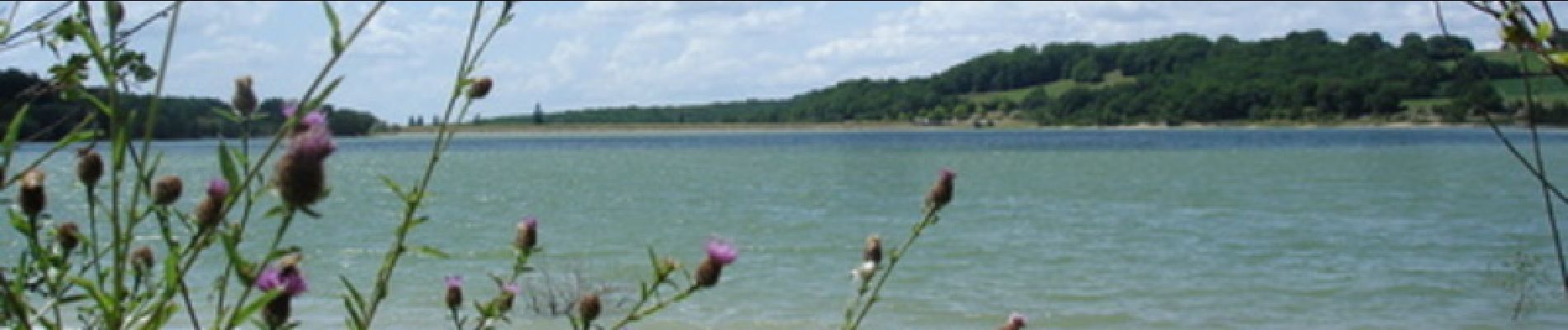
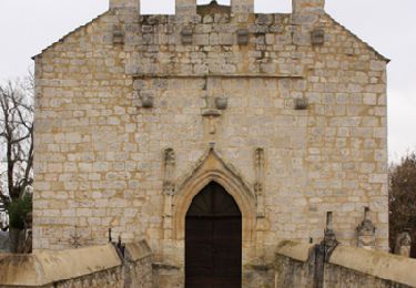
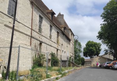
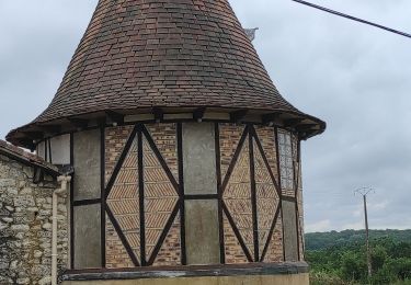
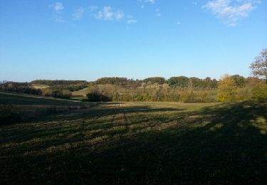
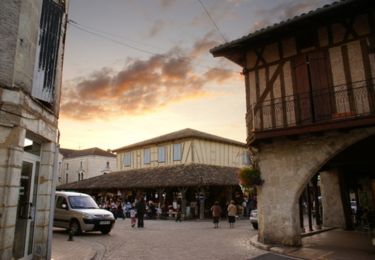
Circuit de la Bastide Royale - Villeréal - Pays du Dropt Dans un paysage de polyculture associant élévage de canard gras du Sud-Ouest, vergers de pruniers et de noisetiers, champs de céréales et prairies où paissent chevaux et Blondes d'Aquitaine, vous roulerez de Villeréal en villages. Entre des haltes gourmandes dans les fermes ou curieuses à l'observatoire des oiseaux du lac du Brayssou, vous découvrirez des églises romanes, des châteaux, des pigeonniers mais aussi un patrimoine insolite : maisons à empilages et maisons brassières. Téléchargez la fiche de cette randonnée sur le site du Tourisme du Lot et Garonne.
Plaatsbepaling
Opmerkingen
Wandeltochten in de omgeving
![Tocht Stappen Rayet - Un sentier de découverte autour de la retenue de la Ganne - Rayet - Photo](https://media.geolcdn.com/t/375/260/ext.jpg?maxdim=2&url=https%3A%2F%2Fservices.sitytrail.com%2FGeolivesWS%2FDownloadMedia.ashx%3FTrailID%3D318109%26Media%3D17570_4.jpg)
![Stappen Stappen](https://static1.geolcdn.com/sitytour/trail-icons/101.png)
Stappen
![](/images/other/stat-length.png)
![](https://static1.geolcdn.com/siteimages/upload/files/16400158638029165_repeat_loop_refresh_sync_direction_icon.png)
![Tocht Wegfiets Rives - Villeréal - Issigeac AR - Photo](https://media.geolcdn.com/t/375/260/ext.jpg?maxdim=2&url=https%3A%2F%2Fmedia.geolcdn.com%2Ff%2Ffda5ff88-c5cc-4838-8a5a-037ed8b4adc9.jpg)
![Wegfiets Wegfiets](https://static1.geolcdn.com/sitytour/trail-icons/201.png)
Wegfiets
![](/images/other/stat-length.png)
![](https://static1.geolcdn.com/siteimages/upload/files/16400158638029165_repeat_loop_refresh_sync_direction_icon.png)
![Tocht Wegfiets Rives - Villeréal - Castillonès AR - Photo](https://media.geolcdn.com/t/375/260/ext.jpg?maxdim=2&url=https%3A%2F%2Fmedia.geolcdn.com%2Ff%2Fcfc3b4db-d132-4b5b-97df-3bd86e49d992.jpg)
![Wegfiets Wegfiets](https://static1.geolcdn.com/sitytour/trail-icons/201.png)
Wegfiets
![](/images/other/stat-length.png)
![](https://static1.geolcdn.com/siteimages/upload/files/16400158638029165_repeat_loop_refresh_sync_direction_icon.png)
![Tocht Stappen Montaut - Montaut-Lafaurie 12km - Photo](https://media.geolcdn.com/t/375/260/ext.jpg?maxdim=2&url=https%3A%2F%2Fservices.sitytrail.com%2FGeolivesWS%2FDownloadMedia.ashx%3FTrailID%3D1073568%26Media%3Dfix__20181118155631.jpg)
![Stappen Stappen](https://static1.geolcdn.com/sitytour/trail-icons/101.png)
Stappen
![](/images/other/stat-length.png)
![](https://static1.geolcdn.com/siteimages/upload/files/16400158638029165_repeat_loop_refresh_sync_direction_icon.png)
![Tocht Paard Villeréal - Villeréal, de la Bastide à l'église de Parisot - Pays du Dropt - Photo](https://media.geolcdn.com/t/375/260/ext.jpg?maxdim=2&url=https%3A%2F%2Fservices.sitytrail.com%2FGeolivesWS%2FDownloadMedia.ashx%3FTrailID%3D111001%26Media%3D6380_1.jpg)
![Paard Paard](https://static1.geolcdn.com/sitytour/trail-icons/300.png)
Paard
![](/images/other/stat-length.png)
![](https://static1.geolcdn.com/siteimages/upload/files/16400158638029165_repeat_loop_refresh_sync_direction_icon.png)
![Tocht Mountainbike Villeréal - Villeréal, de la Bastide à l'église de Parisot - Pays du Dropt - Photo](https://media.geolcdn.com/t/375/260/ext.jpg?maxdim=2&url=https%3A%2F%2Fservices.sitytrail.com%2FGeolivesWS%2FDownloadMedia.ashx%3FTrailID%3D111000%26Media%3D6380_1.jpg)
![Mountainbike Mountainbike](https://static1.geolcdn.com/sitytour/trail-icons/202.png)
Mountainbike
![](/images/other/stat-length.png)
![](https://static1.geolcdn.com/siteimages/upload/files/16400158638029165_repeat_loop_refresh_sync_direction_icon.png)
![Tocht Stappen Villeréal - Villeréal, de la Bastide à l'église de Parisot - Pays du Dropt - Photo](https://media.geolcdn.com/t/375/260/ext.jpg?maxdim=2&url=https%3A%2F%2Fservices.sitytrail.com%2FGeolivesWS%2FDownloadMedia.ashx%3FTrailID%3D110999%26Media%3D6380_1.jpg)
![Stappen Stappen](https://static1.geolcdn.com/sitytour/trail-icons/101.png)
Stappen
![](/images/other/stat-length.png)
![](https://static1.geolcdn.com/siteimages/upload/files/16400158638029165_repeat_loop_refresh_sync_direction_icon.png)
![Tocht Paard Villeréal - Villeréal, le circuit de la bastide royale - Pays du Dropt - Photo](https://media.geolcdn.com/t/375/260/ext.jpg?maxdim=2&url=https%3A%2F%2Fservices.sitytrail.com%2FGeolivesWS%2FDownloadMedia.ashx%3FTrailID%3D110998%26Media%3D6379_2.jpg)
![Paard Paard](https://static1.geolcdn.com/sitytour/trail-icons/300.png)
Paard
![](/images/other/stat-length.png)
![](https://static1.geolcdn.com/siteimages/upload/files/16400158638029165_repeat_loop_refresh_sync_direction_icon.png)
![Tocht Mountainbike Villeréal - Villeréal, le circuit de la bastide royale - Pays du Dropt - Photo](https://media.geolcdn.com/t/375/260/ext.jpg?maxdim=2&url=https%3A%2F%2Fservices.sitytrail.com%2FGeolivesWS%2FDownloadMedia.ashx%3FTrailID%3D110997%26Media%3D6379_2.jpg)
![Mountainbike Mountainbike](https://static1.geolcdn.com/sitytour/trail-icons/202.png)
Mountainbike
![](/images/other/stat-length.png)
![](https://static1.geolcdn.com/siteimages/upload/files/16400158638029165_repeat_loop_refresh_sync_direction_icon.png)