Tocht Stappen Bucey-en-Othe - Bucey 19032019 - Photo
 FPortier
FPortier

Gebruiker

© OpenStreetMap contributors
Lengte
Lengte
10,2 km
Max. hoogte
Max. hoogte
244 m
Positief hoogteverschil
205 m
Km-Effort
Km-Effort  
13 km
Min. hoogte
Min. hoogte
141 m
Negatief hoogteverschil
204 m
Boucle
Boucle
Ja
Datum van aanmaak :
2019-04-01 20:08:20.464
Laatste wijziging :
2019-04-01 20:08:20.464

(0 Bericht)

Stappen
Stappen
2h21
Moeilijkheid : Medium

Scan deze QR-code om de tocht te openen in de SityTrail-applicatie

Gratisgps-wandelapplicatie

Logo SityTrail SityTrail

IGN / Geografische instituten

SityTrail uit de App Store downloaden SityTrail uit Google Play downloaden

Logo SityTrail SityTrail World

De wereld gaat voor u open

SityTrail uit de App Store downloaden SityTrail uit Google Play downloaden SityTrail op Huawei AppGallery downloaden

Over ons

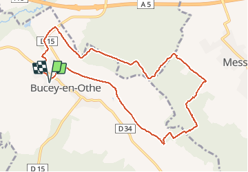
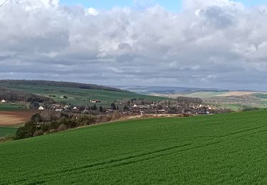
Tocht Stappen van 10,2 km beschikbaar op Grand Est, Aube, Bucey-en-Othe. Deze tocht wordt voorgesteld door FPortier.

Beschrijving

Balade Bucey en Othe
Quelques cotes ...

Hoogteprofiel

Foto's

POI's

POI Bercenay-en-Othe - Point 1essai - Photo
FPortier
BERCENAY-EN-OTHE 
POI Bercenay-en-Othe - Point 2 - Photo
FPortier
BERCENAY-EN-OTHE 
POI Bucey-en-Othe - Croix St Rock - Photo
FPortier
BUCEY-EN-OTHE 
POI Bucey-en-Othe - Petit étang  - Photo
FPortier
BUCEY-EN-OTHE 
POI Bucey-en-Othe - Le Dindon Blanc - Photo
FPortier
BUCEY-EN-OTHE 
POI Messon - Bois de Vieux - Photo
FPortier
POI Messon - Cabane de Messon - Photo
FPortier
POI Messon - Messon - Photo
FPortier
MESSON 
POI Bucey-en-Othe - Vue sur Bucey - Photo
FPortier
BUCEY-EN-OTHE 
POI Bucey-en-Othe - Vue sur Bucey - Photo
FPortier
BUCEY-EN-OTHE 
POI Bucey-en-Othe - Fonvannes - Photo
FPortier
BUCEY-EN-OTHE 
POI Bucey-en-Othe - Lavoir de Bucey - Photo
FPortier
BUCEY-EN-OTHE 

Plaatsbepaling

Land:
France
Regio :
Grand Est
Departement/Provincie :
Aube
Gemeente :
Bucey-en-Othe
Locatie:
Unknown
Vertrek:(Dec)
Vertrek:(UTM)
563844 ; 5345556 (31U) N.

Wandeltochten in de omgeving

Tocht Stappen Chennegy - Le chemin du patrimoine du Valdreux - Photo
Stappen
gildascb

Stappen

Heel gemakkelijk
(1)
Chennegy, Grand Est, Aube, France
8,6 km | 10,5 km-effort
1h 57min
Ja
Tocht Stappen Vauchassis - Randonnée Bucey 23 04 2024 - Photo
Stappen
FPortier

Stappen

Moeilijk
Vauchassis, Grand Est, Aube, France
10,5 km | 13,4 km-effort
3h 5min
Ja
Tocht Stappen Bucey-en-Othe - Bucey en Othe - Photo
Stappen
FPortier

Stappen

Moeilijk
Bucey-en-Othe, Grand Est, Aube, France
10 km | 12,6 km-effort
3h 0min
Ja
Tocht Stappen Vauchassis - Balade Forêt communale de Vauchassis - Photo
Stappen
FPortier

Stappen

Medium
Vauchassis, Grand Est, Aube, France
7,5 km | 9,1 km-effort
2h 26min
Ja
Tocht Stappen Vauchassis - Vauchassis Bercenay Vauchassis - Photo
Stappen
FPortier

Stappen

Moeilijk
Vauchassis, Grand Est, Aube, France
10,3 km | 13 km-effort
3h 2min
Ja
Tocht Stappen Vauchassis - Randonnée Grands Bois Vauchassis - Photo
Stappen
FPortier

Stappen

Medium
Vauchassis, Grand Est, Aube, France
9,7 km | 12 km-effort
2h 51min
Ja
Tocht Stappen Chennegy - Randonnée à Chennegy - Photo
Stappen
FPortier

Stappen

Moeilijk
Chennegy, Grand Est, Aube, France
10,6 km | 12,4 km-effort
3h 5min
Ja
Tocht Stappen Vauchassis - Mars072024 - Photo
Stappen
FPortier

Stappen

Medium
(1)
Vauchassis, Grand Est, Aube, France
7,1 km | 9,3 km-effort
2h 7min
Ja
Tocht Stappen Bucey-en-Othe - Balade autour de Bicey - Photo
Stappen
FPortier

Stappen

Moeilijk
Bucey-en-Othe, Grand Est, Aube, France
9,6 km | 12,5 km-effort
2h 50min
Ja


Sluiten
Mijn abonnementen