Tocht Stappen Jonquières-Saint-Vincent - Sur les traces de la Via Domitia - Jonquières-St-Vincent - Photo

Sur les traces de la Via Domitia - Jonquières-St-Vincent

 tracegps
tracegps

Gebruiker

© OpenStreetMap contributors
Lengte
Lengte
10,2 km
Max. hoogte
Max. hoogte
65 m
Positief hoogteverschil
103 m
Km-Effort
Km-Effort  
11,5 km
Min. hoogte
Min. hoogte
18 m
Negatief hoogteverschil
106 m
Boucle
Boucle
Ja
Datum van aanmaak :
2014-12-10 00:00:00.0
Laatste wijziging :
2014-12-10 00:00:00.0

(1 Bericht)

Stappen
Stappen
2h30
Moeilijkheid : Medium

Scan deze QR-code om de tocht te openen in de SityTrail-applicatie

Gratisgps-wandelapplicatie

Logo SityTrail SityTrail

IGN / Geografische instituten

SityTrail uit de App Store downloaden SityTrail uit Google Play downloaden

Logo SityTrail SityTrail World

De wereld gaat voor u open

SityTrail uit de App Store downloaden SityTrail uit Google Play downloaden SityTrail op Huawei AppGallery downloaden

Over ons

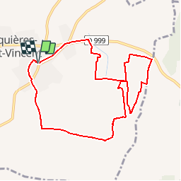
Tocht Stappen van 10,2 km beschikbaar op Occitanië, Gard, Jonquières-Saint-Vincent. Deze tocht wordt voorgesteld door tracegps.

Beschrijving

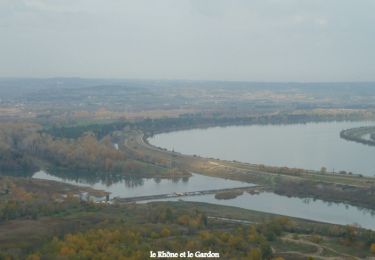
Circuit proposé par la commune de Jonquières Saint Vincent. Situé sur le passage de la Voie Domitienne, Jonquières Saint Vincent est un village paisible où il fait bon vivre. A l’est du Canton de Beaucaire dans le Gard, la petite plaine de Jonquières-Saint-Vincent est un site original, incisé en creux dans la plaine de la Costière. Départ place de la mairie de Jonquières-St-Vincent. Retrouvez le circuit et son descriptif sur le site de la commune de Jonquières-St-Vincent.

Hoogteprofiel

Foto's

Plaatsbepaling

Land:
France
Regio :
Occitanië
Departement/Provincie :
Gard
Gemeente :
Jonquières-Saint-Vincent
Locatie:
Unknown
Vertrek:(Dec)
Vertrek:(UTM)
625687 ; 4853881 (31T) N.

Opmerkingen

Gelieve in te loggen om een commentaar of een beoordeling achter te laten


Wandeltochten in de omgeving

Tocht Stappen Jonquières-Saint-Vincent - Voie romaine  - Jonquières St Vincent - Photo
Stappen
tracegps

Stappen

Medium
(1)
Jonquières-Saint-Vincent, Occitanië, Gard, France
15,3 km | 17,6 km-effort
4h 0min
Ja
Tocht Stappen Comps - Abbaye de St-Roman - Photo
Stappen
Amaralain

Stappen

Gemakkelijk
(1)
Comps, Occitanië, Gard, France
5 km | 6,8 km-effort
1h 27min
Ja
Tocht Stappen Jonquières-Saint-Vincent - JONQUIERES 2023-03-21 - Photo
Stappen
rando30129

Stappen

Medium
(1)
Jonquières-Saint-Vincent, Occitanië, Gard, France
9,6 km | 10,8 km-effort
2h 49min
Ja
Tocht Hybride fiets Comps - Voie verte depuis barrage de Vallabrègues Intersport Marguillier Saint Félix et fin au château de Beaucaire  - Photo
Hybride fiets
jacqk

Hybride fiets

Gemakkelijk
Comps, Occitanië, Gard, France
9,1 km | 10,4 km-effort
1h 0min
Neen
Tocht Stappen Beaucaire - beaucaire mourgues-du-grexs-malatrache - Photo
Stappen
rando30129

Stappen

Medium
(1)
Beaucaire, Occitanië, Gard, France
8,6 km | 9,9 km-effort
2h 15min
Ja
Tocht Stappen Comps - Abbaye de St Roman - Comps - Photo
Stappen
tracegps

Stappen

Medium
(2)
Comps, Occitanië, Gard, France
14 km | 17,9 km-effort
4h 0min
Ja
Tocht Stappen Comps - Comps- l'aiguille  - Photo
Stappen
Manoune

Stappen

Medium
Comps, Occitanië, Gard, France
14,1 km | 17,6 km-effort
4h 16min
Ja
Tocht Te voet Jonquières-Saint-Vincent - Randonnée la Voie Domitia - Photo
Te voet
PRO

Te voet

Gemakkelijk
Jonquières-Saint-Vincent, Occitanië, Gard, France
9,5 km | 10 km-effort
2h 16min
Neen
Tocht Stappen Jonquières-Saint-Vincent - Jonquières - Enclos argent Milliaire - Photo
Stappen
rando30129

Stappen

Medium
(1)
Jonquières-Saint-Vincent, Occitanië, Gard, France
9,3 km | 10,5 km-effort
2h 35min
Ja


Sluiten
Mijn abonnementen