Tocht Stappen Mont-l'Évêque - Autour de Mont l'Evèque - Photo

Autour de Mont l'Evèque

 tracegps
tracegps

Gebruiker

© OpenStreetMap contributors
Lengte
Lengte
7 km
Max. hoogte
Max. hoogte
94 m
Positief hoogteverschil
61 m
Km-Effort
Km-Effort  
7,8 km
Min. hoogte
Min. hoogte
63 m
Negatief hoogteverschil
62 m
Boucle
Boucle
Ja
Datum van aanmaak :
2014-12-10 00:00:00.0
Laatste wijziging :
2014-12-10 00:00:00.0

(0 Bericht)

Stappen
Stappen
1h45
Moeilijkheid : Gemakkelijk

Scan deze QR-code om de tocht te openen in de SityTrail-applicatie

Gratisgps-wandelapplicatie

Logo SityTrail SityTrail

IGN / Geografische instituten

SityTrail uit de App Store downloaden SityTrail uit Google Play downloaden

Logo SityTrail SityTrail World

De wereld gaat voor u open

SityTrail uit de App Store downloaden SityTrail uit Google Play downloaden SityTrail op Huawei AppGallery downloaden

Over ons

Tocht Stappen van 7 km beschikbaar op Hauts-de-France, Oise, Mont-l'Évêque. Deze tocht wordt voorgesteld door tracegps.

Beschrijving

Les fermes et maisonnettes s’étagent le long du coteau de la Nonette. Ainsi que le rappelle le nom de la commune, ces terres furent attribuées à l’évêque de Senlis en 1214. L’ancien rendez-vous de chasse royale fut alors transformé en château-fort, dont les tours et les façades ont été surchargées bien plus tard, vers 1843, de décors néogothiques dans le style « troubadour », alors à la mode. Départ : Parking du cimetière le long de la D330 (direction Ermenonville) Retrouvez le circuit circuit sur le site du Parc Naturel régional Oise – Pays de France.

Hoogteprofiel

Foto's

Plaatsbepaling

Land:
France
Regio :
Hauts-de-France
Departement/Provincie :
Oise
Gemeente :
Mont-l'Évêque
Locatie:
Unknown
Vertrek:(Dec)
Vertrek:(UTM)
473226 ; 5449232 (31U) N.

Wandeltochten in de omgeving

Tocht Stappen Villers-Saint-Frambourg-Ognon - MR_OGNON (par BALAGNY-sur-AUNETTE)_5.4Km - Photo
Stappen

Stappen

Medium
(3)
Villers-Saint-Frambourg-Ognon, Hauts-de-France, Oise, France
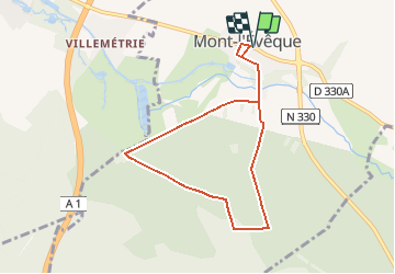
5,4 km | 6,4 km-effort
1h 27min
Ja
Tocht Stappen Senlis - SM_ERMENONVILLE Mais Forest BIAT_7.9Km - Photo
Stappen
GR77LP

Stappen

Medium
(2)
Senlis, Hauts-de-France, Oise, France
7,9 km | 8,9 km-effort
2h 1min
Ja
Tocht Stappen Thiers-sur-Thève - MR_THIERS-sur-THEVE_EST_La Pistole_5.9Km - Photo
Stappen
GR77LP

Stappen

Medium
(3)
Thiers-sur-Thève, Hauts-de-France, Oise, France
5,9 km | 6,6 km-effort
1h 30min
Ja
Tocht Stappen Mont-l'Évêque - SM_MONT-L'EVEQUE_8Km - Photo
Stappen
GR77LP

Stappen

Medium
(4)
Mont-l'Évêque, Hauts-de-France, Oise, France
8,1 km | 9,1 km-effort
1h 59min
Ja
Tocht Stappen Montlognon - MR_MONTLOGNON(Cimetière)_6.1Km - Photo
Stappen
GR77LP

Stappen

Gemakkelijk
(2)
Montlognon, Hauts-de-France, Oise, France
6,1 km | 6,8 km-effort
1h 30min
Ja
Tocht Stappen Fontaine-Chaalis - MR_FONTAINE CHAALIS_5.3Km - Photo
Stappen
GR77LP

Stappen

Gemakkelijk
(4)
Fontaine-Chaalis, Hauts-de-France, Oise, France
5,3 km | 5,9 km-effort
1h 17min
Ja
Tocht Stappen Thiers-sur-Thève - MR_THIERS-sur-THEVE_5.3Km - Photo
Stappen

Stappen

Medium
(4)
Thiers-sur-Thève, Hauts-de-France, Oise, France
5,3 km | 6 km-effort
1h 22min
Ja
Tocht Stappen Borest - SM_BOREST SUD_8Km - Photo
Stappen
GR77LP

Stappen

Medium
(7)
Borest, Hauts-de-France, Oise, France
8 km | 9 km-effort
1h 48min
Ja
Tocht Stappen Montlognon - SM_MONTLOGNON_8.7Km - Photo
Stappen
GR77LP

Stappen

Gemakkelijk
(3)
Montlognon, Hauts-de-France, Oise, France
8,7 km | 10,3 km-effort
2h 14min
Ja


Sluiten
Mijn abonnementen