Tocht Stappen Cahors - De la Rozière à Labastide-Marnhac - Photo

De la Rozière à Labastide-Marnhac

 tracegps
tracegps

Gebruiker

© OpenStreetMap contributors
Lengte
Lengte
17,2 km
Max. hoogte
Max. hoogte
310 m
Positief hoogteverschil
356 m
Km-Effort
Km-Effort  
22 km
Min. hoogte
Min. hoogte
148 m
Negatief hoogteverschil
356 m
Boucle
Boucle
Ja
Datum van aanmaak :
2014-12-10 00:00:00.0
Laatste wijziging :
2014-12-10 00:00:00.0

(0 Bericht)

Stappen
Stappen
3h30
Moeilijkheid : Moeilijk

Scan deze QR-code om de tocht te openen in de SityTrail-applicatie

Gratisgps-wandelapplicatie

Logo SityTrail SityTrail

IGN / Geografische instituten

SityTrail uit de App Store downloaden SityTrail uit Google Play downloaden

Logo SityTrail SityTrail World

De wereld gaat voor u open

SityTrail uit de App Store downloaden SityTrail uit Google Play downloaden SityTrail op Huawei AppGallery downloaden

Over ons

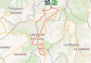
Tocht Stappen van 17,2 km beschikbaar op Occitanië, Lot, Cahors. Deze tocht wordt voorgesteld door tracegps.

Beschrijving

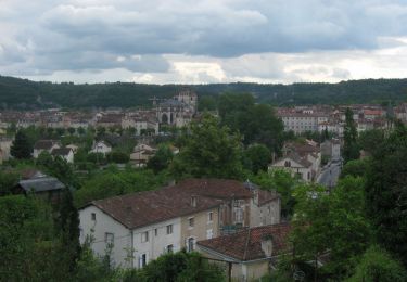
Départ de la salle des fêtes. Prendre la route au sud-ouest de la salle. Après une montée vous descendrez pour traverser la route de D653 (Cahors-Valence d'Agen). Vous traversez le village de Labastide-Marnhac, riche et varié, avec des pièces maîtresses héritées du XIIIe siècle telles que le château, les églises de Labastide et de St Rémy et encore celle de Salgues...

Hoogteprofiel

Foto's

Plaatsbepaling

Land:
France
Regio :
Occitanië
Departement/Provincie :
Lot
Gemeente :
Cahors
Locatie:
Unknown
Vertrek:(Dec)
Vertrek:(UTM)
374080 ; 4919231 (31T) N.

Wandeltochten in de omgeving

Tocht Mountainbike Cahors - Cahors-La Rozière 2005 - Photo
Mountainbike
tracegps

Mountainbike

Zeer moeilijk
(1)
Cahors, Occitanië, Lot, France
62 km | 81 km-effort
5h 0min
Ja
Tocht Stappen Pradines - Cahors les Durands 7km - Photo
Stappen
PariseJL

Stappen

Gemakkelijk
(1)
Pradines, Occitanië, Lot, France
7,1 km | 9,3 km-effort
2h 13min
Ja
Tocht Stappen Cahors - Croix magne  - Photo
Stappen
GUIDE
antignacs

Stappen

Heel gemakkelijk
Cahors, Occitanië, Lot, France
5,2 km | 7,2 km-effort
1h 20min
Neen
Tocht Stappen Cahors - Étape Cahors Lascabannes  - Photo
Stappen
Jean-MarieFaux

Stappen

Gemakkelijk
Cahors, Occitanië, Lot, France
23 km | 30 km-effort
18h 50min
Neen
Tocht Stappen Cahors - CahorsMontcuq - Photo
Stappen
patrickdanilo

Stappen

Medium
Cahors, Occitanië, Lot, France
22 km | 29 km-effort
4h 40min
Neen
Tocht Stappen Labastide-Marnhac - Mon Compostelle huitième étape - Photo
Stappen
Ardeiserois

Stappen

Moeilijk
Labastide-Marnhac, Occitanië, Lot, France
51 km | 65 km-effort
10h 40min
Neen
Tocht Mountainbike Trespoux-Rassiels - Circuit ouest de Trespoux Rassiels - Photo
Mountainbike
tracegps

Mountainbike

Zeer moeilijk
Trespoux-Rassiels, Occitanië, Lot, France
38 km | 51 km-effort
4h 15min
Ja
Tocht Stappen Cahors - Cahors - Lascabanes - Chemin de Compostelle - Photo
Stappen
tracegps

Stappen

Zeer moeilijk
(1)
Cahors, Occitanië, Lot, France
24 km | 31 km-effort
9h 30min
Neen
Tocht Lopen Cahors - Cahors, le Lot, le causse, la vieille ville - Photo
Lopen
tracegps

Lopen

Medium
Cahors, Occitanië, Lot, France
7,3 km | 10 km-effort
45min
Ja


Sluiten
Mijn abonnementen