


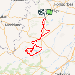


19 km | 23 km-effort


Gebruiker


Gratisgps-wandelapplicatie
 SityTrail
IGN / Geografische instituten
SityTrail World
De wereld gaat voor u open
Tocht Mountainbike van 59 km beschikbaar op Occitanië, Haute-Garonne, Sainte-Foy-de-Peyrolières. Deze tocht wordt voorgesteld door Polo-31.
Ste Foy - Rieumes - Bois de Rieumes - Bois de la Hilaire - Boucle dans bois de la Rougeat - Lautignac - Boucle bois de Bédiau - Savères - Bois de Rieumes - Rieumes et retour Ste Foy par GR86.

Stappen

Stappen
Stappen
Stappen

Lopen

Stappen
Stappen
Stappen

Fiets