Tocht Mountainbike Sainte-Foy-de-Peyrolières - VTT-02 35Km Ste Foy - Bois de Beaupuy - Photo

VTT-02 35Km Ste Foy - Bois de Beaupuy

 Polo-31
Polo-31

Gebruiker

© OpenStreetMap contributors
Lengte
Lengte
36 km
Max. hoogte
Max. hoogte
337 m
Positief hoogteverschil
534 m
Km-Effort
Km-Effort  
43 km
Min. hoogte
Min. hoogte
234 m
Negatief hoogteverschil
533 m
Boucle
Boucle
Ja
Datum van aanmaak :
2014-12-10 00:00:00.0
Laatste wijziging :
2014-12-10 00:00:00.0

(0 Bericht)

Mountainbike
Mountainbike
2h48
Moeilijkheid : Medium

Scan deze QR-code om de tocht te openen in de SityTrail-applicatie

Gratisgps-wandelapplicatie

Logo SityTrail SityTrail

IGN / Geografische instituten

SityTrail uit de App Store downloaden SityTrail uit Google Play downloaden

Logo SityTrail SityTrail World

De wereld gaat voor u open

SityTrail uit de App Store downloaden SityTrail uit Google Play downloaden SityTrail op Huawei AppGallery downloaden

Over ons

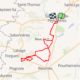
Tocht Mountainbike van 36 km beschikbaar op Occitanië, Haute-Garonne, Sainte-Foy-de-Peyrolières. Deze tocht wordt voorgesteld door Polo-31.

Beschrijving

Ste Foy, Beaufort, Esperes, Forêt de Lahage par le GR86, boucle en huit dans le Bois de Beaupuy, retour à Ste Foy par le chemin en parallèle à la D7.
         

Hoogteprofiel

Plaatsbepaling

Land:
France
Regio :
Occitanië
Departement/Provincie :
Haute-Garonne
Gemeente :
Sainte-Foy-de-Peyrolières
Locatie:
Unknown
Vertrek:(Dec)
Vertrek:(UTM)
349999 ; 4816323 (31T) N.

Wandeltochten in de omgeving

Tocht Stappen Saiguède - Raide de Saiguède - Photo
Stappen
tracegps

Stappen

Moeilijk
(1)
Saiguède, Occitanië, Haute-Garonne, France
19 km | 23 km-effort
4h 0min
Ja
Tocht Stappen Sainte-Foy-de-Peyrolières - RANDO-Ste Foy Téléthon 2012 - Photo
Stappen
Polo-31

Stappen

Gemakkelijk
Sainte-Foy-de-Peyrolières, Occitanië, Haute-Garonne, France
8 km | 9,3 km-effort
2h 2min
Ja
Tocht Stappen Sainte-Foy-de-Peyrolières - Lac et bois autour de Sainte Foy de Peyrolières - Photo
Stappen
tracegps

Stappen

Gemakkelijk
Sainte-Foy-de-Peyrolières, Occitanië, Haute-Garonne, France
9 km | 11,2 km-effort
2h 30min
Ja
Tocht Stappen Sainte-Foy-de-Peyrolières - Ste Foy de Peyrolières 13 Avril 2020 - Photo
Stappen
daniel3157

Stappen

Gemakkelijk
Sainte-Foy-de-Peyrolières, Occitanië, Haute-Garonne, France
16,4 km | 21 km-effort
4h 58min
Ja
Tocht Lopen Saiguède - Raide de Saiguède - Photo
Lopen
tracegps

Lopen

Zeer moeilijk
Saiguède, Occitanië, Haute-Garonne, France
19 km | 23 km-effort
2h 0min
Ja
Tocht Stappen Sainte-Foy-de-Peyrolières - Randonnée Sainte Foy de Peyrolières  - Photo
Stappen
Fafou64

Stappen

Sainte-Foy-de-Peyrolières, Occitanië, Haute-Garonne, France
10,7 km | 12,9 km-effort
2h 39min
Ja
Tocht Stappen Saiguède - Saiguède belles vues - Photo
Stappen
pidjam

Stappen

Heel gemakkelijk
Saiguède, Occitanië, Haute-Garonne, France
8,3 km | 10,5 km-effort
2h 0min
Ja
Tocht Fiets Sainte-Foy-de-Peyrolières - V003-Tour LASSERRE - Photo
Fiets
Polo-31

Fiets

Moeilijk
Sainte-Foy-de-Peyrolières, Occitanië, Haute-Garonne, France
141 km | 163 km-effort
6h 0min
Ja
Tocht Fiets Sainte-Foy-de-Peyrolières - V002-Ste Foy Col de la Core - Photo
Fiets
Polo-31

Fiets

Moeilijk
Sainte-Foy-de-Peyrolières, Occitanië, Haute-Garonne, France
223 km | 260 km-effort
14h 46min
Ja


Sluiten
Mijn abonnementen