Tocht Stappen Millau - la salage - Photo
 colber
colber

Gebruiker

© OpenStreetMap contributors
Lengte
Lengte
11,8 km
Max. hoogte
Max. hoogte
773 m
Positief hoogteverschil
377 m
Km-Effort
Km-Effort  
16,8 km
Min. hoogte
Min. hoogte
587 m
Negatief hoogteverschil
377 m
Boucle
Boucle
Ja
Datum van aanmaak :
2014-12-10 00:00:00.0
Laatste wijziging :
2014-12-10 00:00:00.0

(0 Bericht)

Stappen
Stappen
2h59
Moeilijkheid : Onbekend

Scan deze QR-code om de tocht te openen in de SityTrail-applicatie

Gratisgps-wandelapplicatie

Logo SityTrail SityTrail

IGN / Geografische instituten

SityTrail uit de App Store downloaden SityTrail uit Google Play downloaden

Logo SityTrail SityTrail World

De wereld gaat voor u open

SityTrail uit de App Store downloaden SityTrail uit Google Play downloaden SityTrail op Huawei AppGallery downloaden

Over ons

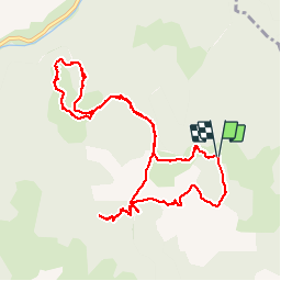
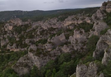
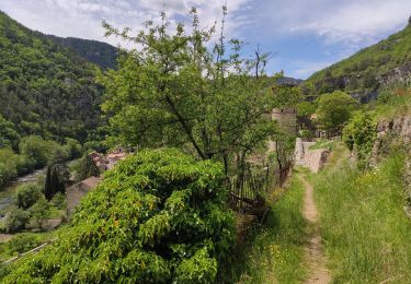
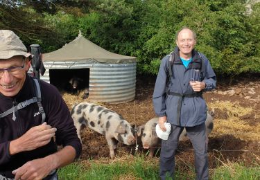
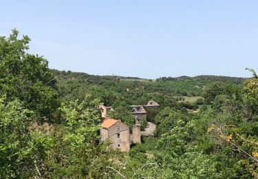
Tocht Stappen van 11,8 km beschikbaar op Occitanië, Aveyron, Millau. Deze tocht wordt voorgesteld door colber.
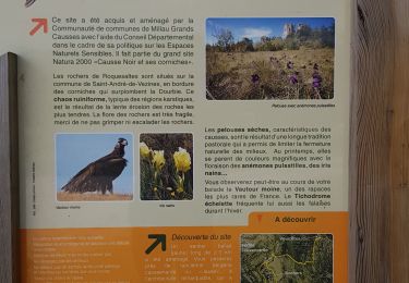
Beschrijving

Moyenne difficulté

Hoogteprofiel

POI's

POI Millau - Point 1 - Photo
colber
MILLAU 
POI Millau - Point 2 - Photo
colber
MILLAU 
POI Millau - Point 3 - Photo
colber
MILLAU 
POI Millau - Point 4 - Photo
colber
MILLAU 

Plaatsbepaling

Land:
France
Regio :
Occitanië
Departement/Provincie :
Aveyron
Gemeente :
Millau
Locatie:
Unknown
Vertrek:(Dec)
Vertrek:(UTM)
515138 ; 4882440 (31T) N.

Wandeltochten in de omgeving

Tocht Stappen Millau - le chaos de Caoussou - Photo
Stappen
GUIDE
amiral13

Stappen

Moeilijk
Millau, Occitanië, Aveyron, France
14,1 km | 17,9 km-effort
4h 4min
Ja
Tocht Stappen La Roque-Sainte-Marguerite - Montredon - Photo
Stappen
nolsim

Stappen

Gemakkelijk
(1)
La Roque-Sainte-Marguerite, Occitanië, Aveyron, France
9,6 km | 11,5 km-effort
2h 13min
Ja
Tocht Stappen Saint-André-de-Vézines - site de roquesaltes - Photo
Stappen
smoltmat65

Stappen

Gemakkelijk
Saint-André-de-Vézines, Occitanië, Aveyron, France
4,6 km | 6 km-effort
3h 4min
Neen
Tocht Stappen La Roque-Sainte-Marguerite - 12 chaos Montpellier le vx roquesaltes - Photo
Stappen
himba26100

Stappen

Medium
La Roque-Sainte-Marguerite, Occitanië, Aveyron, France
19,6 km | 29 km-effort
7h 38min
Ja
Tocht Stappen La Roque-Sainte-Marguerite - Roquesalte depuis la roque st marguerite - Photo
Stappen
marcagif

Stappen

Medium
La Roque-Sainte-Marguerite, Occitanië, Aveyron, France
9 km | 15,1 km-effort
2h 50min
Ja
Tocht Stappen La Roque-Sainte-Marguerite - Montredon Salvage - Photo
Stappen
janussity

Stappen

Heel gemakkelijk
La Roque-Sainte-Marguerite, Occitanië, Aveyron, France
19,9 km | 26 km-effort
8h 25min
Neen
Tocht Stappen Millau - Le cun nant - Photo
Stappen
Glurps

Stappen

Zeer moeilijk
Millau, Occitanië, Aveyron, France
20 km | 27 km-effort
5h 15min
Neen
Tocht Stappen Millau - monna baume rouge - Photo
Stappen
lablaquiere

Stappen

Medium
Millau, Occitanië, Aveyron, France
3,3 km | 6,3 km-effort
1h 9min
Ja
Tocht Stappen Saint-André-de-Vézines - grotte pigeonnier de montmejean aller retour  - Photo
Stappen
lablaquiere

Stappen

Gemakkelijk
Saint-André-de-Vézines, Occitanië, Aveyron, France
3,5 km | 5,3 km-effort
1h 30min
Ja


Sluiten
Mijn abonnementen