Tocht Mountainbike Le Hom - Tour de la Suisse Normande - officiel - Photo

Tour de la Suisse Normande - officiel

 tracegps
tracegps

Gebruiker

© OpenStreetMap contributors
Lengte
Lengte
117 km
Max. hoogte
Max. hoogte
291 m
Positief hoogteverschil
2523 m
Km-Effort
Km-Effort  
151 km
Min. hoogte
Min. hoogte
18 m
Negatief hoogteverschil
2522 m
Boucle
Boucle
Ja
Datum van aanmaak :
2014-12-10 00:00:00.0
Laatste wijziging :
2014-12-10 00:00:00.0

(0 Bericht)

Mountainbike
Mountainbike
12h00
Moeilijkheid : Zeer moeilijk

Scan deze QR-code om de tocht te openen in de SityTrail-applicatie

Gratisgps-wandelapplicatie

Logo SityTrail SityTrail

IGN / Geografische instituten

SityTrail uit de App Store downloaden SityTrail uit Google Play downloaden

Logo SityTrail SityTrail World

De wereld gaat voor u open

SityTrail uit de App Store downloaden SityTrail uit Google Play downloaden SityTrail op Huawei AppGallery downloaden

Over ons

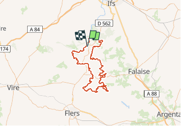
Tocht Mountainbike van 117 km beschikbaar op Normandië, Calvados, Le Hom. Deze tocht wordt voorgesteld door tracegps.

Beschrijving

Circuit officiel du tour de la Suisse Normande. Ne le trouvant nulle part, je l'ai retranscrit sur GPS à partir des cartes des circuits de la suisse normande. Je ne l'ai pas encore fait, c'est un projet pour mi septembre avec 5 potes. J'espère que vous serait nombreux a profiter de ces belles traces de VTT. Bon ride.

Hoogteprofiel

Foto's

Plaatsbepaling

Land:
France
Regio :
Normandië
Departement/Provincie :
Calvados
Gemeente :
Le Hom
Locatie:
Thury-Harcourt
Vertrek:(Dec)
Vertrek:(UTM)
684112 ; 5429044 (30U) N.

Wandeltochten in de omgeving

Tocht Te voet Le Hom - La Vallée de l'Orne - Photo
Te voet
PRO

Te voet

Medium
Le Hom, Normandië, Calvados, France
17,1 km | 23 km-effort
5h 10min
Ja
Tocht Te voet Culey-le-Patry - Le Mouin du Fay - Photo
Te voet
PRO

Te voet

Gemakkelijk
Culey-le-Patry, Normandië, Calvados, France
4,8 km | 6,7 km-effort
1h 31min
Neen
Tocht Te voet Espins - D'Espins au Moulin du traspy - Photo
Te voet
PRO

Te voet

Gemakkelijk
Espins, Normandië, Calvados, France
6,9 km | 9 km-effort
2h 3min
Ja
Tocht Te voet Esson - La Chapelle Bonne Nouvelle - Photo
Te voet
PRO

Te voet

Gemakkelijk
Esson, Normandië, Calvados, France
9,5 km | 13,3 km-effort
3h 1min
Ja
Tocht Te voet Esson - GRP Tour de la Suisse Normande - Photo
Te voet
PRO

Te voet

Moeilijk
Esson, Normandië, Calvados, France
25 km | 35 km-effort
7h 58min
Neen
Tocht Mountainbike Saint-Rémy - VTT Suisse Normande N°10 - St Rémy sur Orne - Photo
Mountainbike
tracegps

Mountainbike

Gemakkelijk
Saint-Rémy, Normandië, Calvados, France
15,8 km | 20 km-effort
1h 30min
Ja
Tocht Stappen Le Hom - le pont Hom (boucle) - Photo
Stappen
jlesacher

Stappen

Medium
(1)
Le Hom, Normandië, Calvados, France
12,1 km | 16 km-effort
2h 45min
Ja
Tocht Te voet Saint-Rémy - La Mousse - Photo
Te voet
PRO

Te voet

Gemakkelijk
Saint-Rémy, Normandië, Calvados, France
7,3 km | 9,6 km-effort
2h 10min
Neen
Tocht Te voet Cesny-les-Sources - De Placy à la Motte - Photo
Te voet
PRO

Te voet

Gemakkelijk
Cesny-les-Sources, Normandië, Calvados, France
7,1 km | 8,4 km-effort
1h 54min
Ja


Sluiten
Mijn abonnementen