Tocht Mountainbike Chaource - Circuit des Forêts - Chaource - Photo

Circuit des Forêts - Chaource

 tracegps
tracegps

Gebruiker

© OpenStreetMap contributors
Lengte
Lengte
22 km
Max. hoogte
Max. hoogte
191 m
Positief hoogteverschil
263 m
Km-Effort
Km-Effort  
25 km
Min. hoogte
Min. hoogte
131 m
Negatief hoogteverschil
262 m
Boucle
Boucle
Ja
Datum van aanmaak :
2014-12-10 00:00:00.0
Laatste wijziging :
2014-12-10 00:00:00.0

(0 Bericht)

Mountainbike
Mountainbike
1h45
Moeilijkheid : Gemakkelijk

Scan deze QR-code om de tocht te openen in de SityTrail-applicatie

Gratisgps-wandelapplicatie

Logo SityTrail SityTrail

IGN / Geografische instituten

SityTrail uit de App Store downloaden SityTrail uit Google Play downloaden

Logo SityTrail SityTrail World

De wereld gaat voor u open

SityTrail uit de App Store downloaden SityTrail uit Google Play downloaden SityTrail op Huawei AppGallery downloaden

Over ons

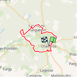
Tocht Mountainbike van 22 km beschikbaar op Grand Est, Aube, Chaource. Deze tocht wordt voorgesteld door tracegps.

Beschrijving

Au départ de l’Eglise de Chaource et sa célèbre Mise au tombeau, partez sur les chemins agricoles des plaines de culture et d’élevage avant de pénétrer dans le plus grand massif forestier du département. Au détour du circuit, observez la rivière de l’Armance, les beaux chênes de nos forêts, le site patrimonial des Poteries, l’arboretum Jean Beugnon ou encore le Golf de la Cordelière. Ouvrez l’œil, vous apercevrez peut-être chevreuils, sangliers ou renards, nombreux dans le secteur.

Hoogteprofiel

Foto's

Plaatsbepaling

Land:
France
Regio :
Grand Est
Departement/Provincie :
Aube
Gemeente :
Chaource
Locatie:
Unknown
Vertrek:(Dec)
Vertrek:(UTM)
584727 ; 5323374 (31U) N.

Wandeltochten in de omgeving

Tocht Stappen Cussangy - Circuit des petits gués - Cussangy - Photo
Stappen
tracegps

Stappen

Gemakkelijk
Cussangy, Grand Est, Aube, France
5,1 km | 5,7 km-effort
1h 15min
Ja
Tocht Stappen Chaource - Circuit du Chaourçais - Chaource - Photo
Stappen
tracegps

Stappen

Zeer moeilijk
Chaource, Grand Est, Aube, France
18,5 km | 21 km-effort
4h 30min
Ja
Tocht Fiets Chaource - Au pays du fromage de Chaource - Photo
Fiets
tracegps

Fiets

Medium
Chaource, Grand Est, Aube, France
73 km | 86 km-effort
3h 0min
Ja
Tocht Mountainbike Chaource - Chaource. Circuit des Forêts - Photo
Mountainbike
papadoc

Mountainbike

Gemakkelijk
Chaource, Grand Est, Aube, France
21 km | 24 km-effort
1h 24min
Ja
Tocht Stappen Cussangy - cussangy avril 24 - Photo
Stappen
bougnaou

Stappen

Medium
Cussangy, Grand Est, Aube, France
13,6 km | 15,6 km-effort
3h 11min
Ja
Tocht Stappen Praslin - Praslin - Photo
Stappen
randobe

Stappen

Zeer moeilijk
Praslin, Grand Est, Aube, France
22 km | 26 km-effort
5h 51min
Ja
Tocht Mountainbike Metz-Robert - metz maisons - Photo
Mountainbike
joeljoseph

Mountainbike

Moeilijk
Metz-Robert, Grand Est, Aube, France
42 km | 49 km-effort
2h 9min
Ja
Tocht Mountainbike Chaource - chaource pargues 2 - Photo
Mountainbike
joeljoseph

Mountainbike

Zeer moeilijk
Chaource, Grand Est, Aube, France
49 km | 57 km-effort
2h 37min
Ja
Tocht Stappen Chaource - chaource - Photo
Stappen
bougnaou

Stappen

Gemakkelijk
Chaource, Grand Est, Aube, France
10 km | 11,4 km-effort
2h 20min
Ja


Sluiten
Mijn abonnementen