Tocht Mountainbike Sainte-Radegonde - Combelles et les Crêtes - Photo

Combelles et les Crêtes

 tracegps
tracegps

Gebruiker

© OpenStreetMap contributors
Lengte
Lengte
19,7 km
Max. hoogte
Max. hoogte
809 m
Positief hoogteverschil
502 m
Km-Effort
Km-Effort  
26 km
Min. hoogte
Min. hoogte
591 m
Negatief hoogteverschil
507 m
Boucle
Boucle
Ja
Datum van aanmaak :
2014-12-10 00:00:00.0
Laatste wijziging :
2014-12-10 00:00:00.0

(0 Bericht)

Mountainbike
Mountainbike
3h04
Moeilijkheid : Moeilijk

Scan deze QR-code om de tocht te openen in de SityTrail-applicatie

Gratisgps-wandelapplicatie

Logo SityTrail SityTrail

IGN / Geografische instituten

SityTrail uit de App Store downloaden SityTrail uit Google Play downloaden

Logo SityTrail SityTrail World

De wereld gaat voor u open

SityTrail uit de App Store downloaden SityTrail uit Google Play downloaden SityTrail op Huawei AppGallery downloaden

Over ons

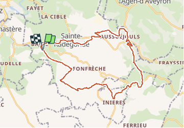
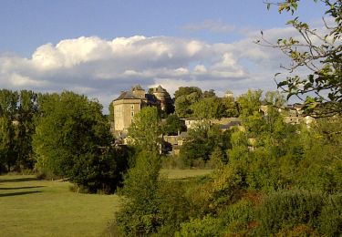
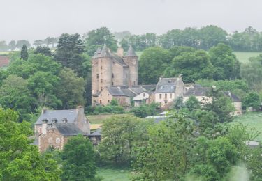
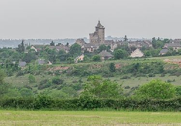
Tocht Mountainbike van 19,7 km beschikbaar op Occitanië, Aveyron, Sainte-Radegonde. Deze tocht wordt voorgesteld door tracegps.

Beschrijving

Une boucle avec des descentes assez techniques. Pour finir vous pouvez allez dans les bois, attention plusieurs possibilités et les branches sont basses ! Bonne balade! Pour plus de photo voici un Lien .

Hoogteprofiel

Foto's

Plaatsbepaling

Land:
France
Regio :
Occitanië
Departement/Provincie :
Aveyron
Gemeente :
Sainte-Radegonde
Locatie:
Unknown
Vertrek:(Dec)
Vertrek:(UTM)
468691 ; 4908849 (31T) N.

Wandeltochten in de omgeving

Tocht Te voet Rodez - Randonnée de Rodez Agglomération Circuit n°2 - Layoule - Photo
Te voet
PRO

Te voet

Gemakkelijk
Rodez, Occitanië, Aveyron, France
5,6 km | 6,6 km-effort
1h 29min
Ja
Tocht Te voet Onet-le-Château - Circuit 16 Moulin de cantarane - Photo
Te voet
PRO

Te voet

Gemakkelijk
Onet-le-Château, Occitanië, Aveyron, France
6,3 km | 8 km-effort
1h 48min
Ja
Tocht Te voet Sainte-Radegonde - Circuit 15 Inières - Photo
Te voet
PRO

Te voet

Gemakkelijk
Sainte-Radegonde, Occitanië, Aveyron, France
5,6 km | 8,2 km-effort
1h 51min
Ja
Tocht Te voet Sainte-Radegonde - Circuit 14 Sainte-Radegonde - Photo
Te voet
PRO

Te voet

Gemakkelijk
Sainte-Radegonde, Occitanië, Aveyron, France
12,2 km | 16,2 km-effort
3h 40min
Ja
Tocht Te voet Le Monastère - Circuit 11 Le Monsastère - Photo
Te voet
PRO

Te voet

Gemakkelijk
Le Monastère, Occitanië, Aveyron, France
6,4 km | 7,9 km-effort
1h 47min
Neen
Tocht Te voet Luc-la-Primaube - Circuit 10 La Capelle Saint-Martin - Photo
Te voet
PRO

Te voet

Gemakkelijk
Luc-la-Primaube, Occitanië, Aveyron, France
9,6 km | 11,8 km-effort
2h 40min
Neen
Tocht Te voet Olemps - Circuit 8 Le Viel Olemps - Photo
Te voet
PRO

Te voet

Gemakkelijk
Olemps, Occitanië, Aveyron, France
5,1 km | 6,5 km-effort
1h 29min
Ja
Tocht Te voet Rodez - Via Piodensis - Rodez - Photo
Te voet
PRO

Te voet

Zeer moeilijk
Rodez, Occitanië, Aveyron, France
113 km | 150 km-effort
34h 12min
Neen
Tocht Te voet Sainte-Radegonde - Sainte-Radegonde - Photo
Te voet
PRO

Te voet

Gemakkelijk
Sainte-Radegonde, Occitanië, Aveyron, France
9,9 km | 13,2 km-effort
2h 59min
Ja


Sluiten
Mijn abonnementen