Tocht Mountainbike Paray-le-Monial - VTT à Paray le Monial - Boucle Nord - Photo

VTT à Paray le Monial - Boucle Nord

 tracegps
tracegps

Gebruiker

© OpenStreetMap contributors
Lengte
Lengte
34 km
Max. hoogte
Max. hoogte
309 m
Positief hoogteverschil
309 m
Km-Effort
Km-Effort  
38 km
Min. hoogte
Min. hoogte
232 m
Negatief hoogteverschil
309 m
Boucle
Boucle
Ja
Datum van aanmaak :
2014-12-10 00:00:00.0
Laatste wijziging :
2014-12-10 00:00:00.0

(0 Bericht)

Mountainbike
Mountainbike
2h30
Moeilijkheid : Gemakkelijk

Scan deze QR-code om de tocht te openen in de SityTrail-applicatie

Gratisgps-wandelapplicatie

Logo SityTrail SityTrail

IGN / Geografische instituten

SityTrail uit de App Store downloaden SityTrail uit Google Play downloaden

Logo SityTrail SityTrail World

De wereld gaat voor u open

SityTrail uit de App Store downloaden SityTrail uit Google Play downloaden SityTrail op Huawei AppGallery downloaden

Over ons

Tocht Mountainbike van 34 km beschikbaar op Bourgondië-Franche-Comté, Saône-et-Loire, Paray-le-Monial. Deze tocht wordt voorgesteld door tracegps.

Beschrijving

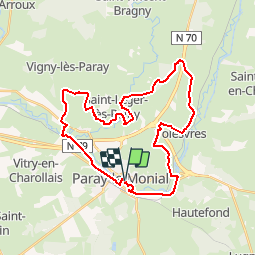
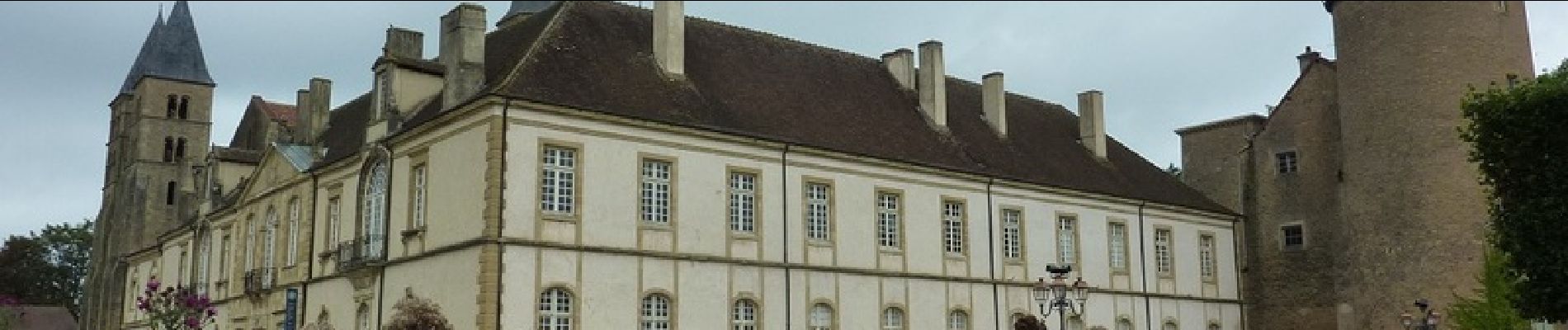
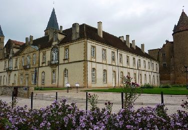
Parking et départ devant l’Office de Tourisme. Pour tracer ce circuit, je me suis inspiré du topoguide cité infra ! Cette boucle au Nord de Paray-le-Monial commence et se termine en empruntant la voie verte qui longe le canal du Centre. Le parcours se révèle très roulant, sans aucune difficulté avec cependant un beau passage « très VTT » à travers le bois du Fourneau. Vous apercevrez même une Tour Eiffel à l’entrée du camping municipal de Volesvres. Sur le retour vous quitterez la voie verte qui longe le canal du Centre afin de traverser le Parc du Moulin Liron puis de longer la Bourbince avant de rejoindre l’Office de Tourisme par la passerelle qui enjambe la rivière. Topoguide : Les Balades Vertes, Pays Charolais Brionnais, Guide de randonnée Paray-le-Monial (12 circuits   Boucle Intercommunale), disponible à l’Office de Tourisme.

Hoogteprofiel

Foto's

Plaatsbepaling

Land:
France
Regio :
Bourgondië-Franche-Comté
Departement/Provincie :
Saône-et-Loire
Gemeente :
Paray-le-Monial
Locatie:
Unknown
Vertrek:(Dec)
Vertrek:(UTM)
586110 ; 5144639 (31T) N.

Wandeltochten in de omgeving

Tocht Mountainbike Paray-le-Monial - VTT à Paray le Monial - Boucle Sud - Photo
Mountainbike
tracegps

Mountainbike

Medium
Paray-le-Monial, Bourgondië-Franche-Comté, Saône-et-Loire, France
35 km | 40 km-effort
3h 0min
Ja
Tocht Te voet Paray-le-Monial - Balade forestière - Photo
Te voet
PRO

Te voet

Gemakkelijk
Paray-le-Monial, Bourgondië-Franche-Comté, Saône-et-Loire, France
8,1 km | 8,9 km-effort
2h 0min
Neen
Tocht Fietstoerisme Paray-le-Monial - TB 5 Paray le Monial  - Bourbon Lancy - Photo
Fietstoerisme
famiski

Fietstoerisme

Heel gemakkelijk
Paray-le-Monial, Bourgondië-Franche-Comté, Saône-et-Loire, France
47 km | 51 km-effort
2h 58min
Neen
Tocht Fiets Paray-le-Monial - 150509 - Photo
Fiets
jpparis

Fiets

Moeilijk
Paray-le-Monial, Bourgondië-Franche-Comté, Saône-et-Loire, France
170 km | 204 km-effort
Onbekend
Ja
Tocht Mountainbike Paray-le-Monial - Boucle Paray-Poisson - Photo
Mountainbike
rocco58

Mountainbike

Gemakkelijk
Paray-le-Monial, Bourgondië-Franche-Comté, Saône-et-Loire, France
26 km | 29 km-effort
Onbekend
Ja
Tocht Elektrische fiets Paray-le-Monial - Paray digoin - Photo
Elektrische fiets
fetievant

Elektrische fiets

Gemakkelijk
Paray-le-Monial, Bourgondië-Franche-Comté, Saône-et-Loire, France
63 km | 68 km-effort
3h 4min
Ja
Tocht Stappen Paray-le-Monial - 2024032_Petite boucle des Chapelles - Photo
Stappen
galain

Stappen

Medium
Paray-le-Monial, Bourgondië-Franche-Comté, Saône-et-Loire, France
8,4 km | 9,4 km-effort
2h 8min
Ja
Tocht Wegfiets Paray-le-Monial - 06 paray le M. Chany - Photo
Wegfiets
berhin

Wegfiets

Zeer moeilijk
Paray-le-Monial, Bourgondië-Franche-Comté, Saône-et-Loire, France
100 km | 111 km-effort
10h 14min
Neen
Tocht Elektrische fiets Paray-le-Monial - Paray le Monial via Luzy-13842423 - Photo
Elektrische fiets
LANDRIEU

Elektrische fiets

Medium
Paray-le-Monial, Bourgondië-Franche-Comté, Saône-et-Loire, France
63 km | 75 km-effort
Onbekend
Neen


Sluiten
Mijn abonnementen