Trail Mountain bike Paray-le-Monial - VTT à Paray le Monial - Boucle Nord - Photo

VTT à Paray le Monial - Boucle Nord

 tracegps
tracegps

User

© OpenStreetMap contributors
Length
Length
34 km
Max alt
Max alt
309 m
Uphill gradient
Uphill gradient
309 m
Km-Effort
Km-Effort  
38 km
Min alt
Min alt
232 m
Downhill gradient
Downhill gradient
309 m
Boucle
Boucle
Yes
Creation date :
2014-12-10 00:00:00.0
Updated on :
2014-12-10 00:00:00.0

(0 Reviews)

Mountain bike
Mountain bike
2h30
Difficulty : Easy

Scan this QR Code to open this trail in the SityTrail application

FREE GPS app for hiking

Logo SityTrail SityTrail

IGN / Geographical institutes

Download SityTrail from the App Store Download SityTrail from Google Play

Logo SityTrail SityTrail World

The world is yours!

Download SityTrail from the App Store Download SityTrail from Google Play Download SityTrail on Huawei AppGallery

About

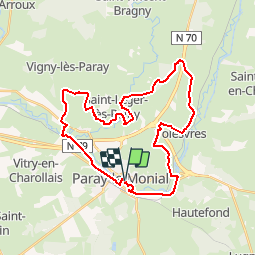
Trail Mountain bike of 34 km to be discovered at Bourgogne-Franche-Comté, Saône-et-Loire, Paray-le-Monial. This trail is proposed by tracegps.

Description

Parking et départ devant l’Office de Tourisme. Pour tracer ce circuit, je me suis inspiré du topoguide cité infra ! Cette boucle au Nord de Paray-le-Monial commence et se termine en empruntant la voie verte qui longe le canal du Centre. Le parcours se révèle très roulant, sans aucune difficulté avec cependant un beau passage « très VTT » à travers le bois du Fourneau. Vous apercevrez même une Tour Eiffel à l’entrée du camping municipal de Volesvres. Sur le retour vous quitterez la voie verte qui longe le canal du Centre afin de traverser le Parc du Moulin Liron puis de longer la Bourbince avant de rejoindre l’Office de Tourisme par la passerelle qui enjambe la rivière. Topoguide : Les Balades Vertes, Pays Charolais Brionnais, Guide de randonnée Paray-le-Monial (12 circuits   Boucle Intercommunale), disponible à l’Office de Tourisme.

Elevation profile

Photos

Positioning

Country:
France
Region :
Bourgogne-Franche-Comté
Department/Province :
Saône-et-Loire
Municipality :
Paray-le-Monial
Location:
Unknown
Start:(UTM)
586110 ; 5144639 (31T) N.

Trails nearby

Trail Mountain bike Paray-le-Monial - VTT à Paray le Monial - Boucle Sud - Photo
Mountain bike
tracegps

Mountain bike

Medium
Paray-le-Monial, Bourgogne-Franche-Comté, Saône-et-Loire, France
35 km | 40 km-effort
3h 0min
Yes
Trail On foot Paray-le-Monial - Balade forestière - Photo
On foot
PRO

On foot

Easy
Paray-le-Monial, Bourgogne-Franche-Comté, Saône-et-Loire, France
8.1 km | 8.9 km-effort
2h 0min
No
Trail Bicycle tourism Paray-le-Monial - TB 5 Paray le Monial  - Bourbon Lancy - Photo
Bicycle tourism
famiski

Bicycle tourism

Very easy
Paray-le-Monial, Bourgogne-Franche-Comté, Saône-et-Loire, France
47 km | 51 km-effort
2h 58min
No
Trail Cycle Paray-le-Monial - 150509 - Photo
Cycle
jpparis

Cycle

Difficult
Paray-le-Monial, Bourgogne-Franche-Comté, Saône-et-Loire, France
170 km | 204 km-effort
Unknown
Yes
Trail Mountain bike Paray-le-Monial - Boucle Paray-Poisson - Photo
Mountain bike
rocco58

Mountain bike

Easy
Paray-le-Monial, Bourgogne-Franche-Comté, Saône-et-Loire, France
26 km | 29 km-effort
Unknown
Yes
Trail Electric bike Paray-le-Monial - Paray digoin - Photo
Electric bike
fetievant

Electric bike

Easy
Paray-le-Monial, Bourgogne-Franche-Comté, Saône-et-Loire, France
63 km | 68 km-effort
3h 4min
Yes
Trail Walking Paray-le-Monial - 2024032_Petite boucle des Chapelles - Photo
Walking
galain

Walking

Medium
Paray-le-Monial, Bourgogne-Franche-Comté, Saône-et-Loire, France
8.4 km | 9.4 km-effort
2h 8min
Yes
Trail Road bike Paray-le-Monial - 06 paray le M. Chany - Photo
Road bike
berhin

Road bike

Very difficult
Paray-le-Monial, Bourgogne-Franche-Comté, Saône-et-Loire, France
100 km | 111 km-effort
10h 14min
No
Trail Electric bike Paray-le-Monial - Paray le Monial via Luzy-13842423 - Photo
Electric bike
LANDRIEU

Electric bike

Medium
Paray-le-Monial, Bourgogne-Franche-Comté, Saône-et-Loire, France
63 km | 75 km-effort
Unknown
No


Close
My subscriptions