Tocht Mountainbike Gavray-sur-Sienne - Randonnée autour de Gavray - Photo

Randonnée autour de Gavray

 tracegps
tracegps

Gebruiker

© OpenStreetMap contributors
Lengte
Lengte
31 km
Max. hoogte
Max. hoogte
169 m
Positief hoogteverschil
599 m
Km-Effort
Km-Effort  
39 km
Min. hoogte
Min. hoogte
27 m
Negatief hoogteverschil
596 m
Boucle
Boucle
Neen
Datum van aanmaak :
2014-12-10 00:00:00.0
Laatste wijziging :
2014-12-10 00:00:00.0

(0 Bericht)

Mountainbike
Mountainbike
2h45
Moeilijkheid : Moeilijk

Scan deze QR-code om de tocht te openen in de SityTrail-applicatie

Gratisgps-wandelapplicatie

Logo SityTrail SityTrail

IGN / Geografische instituten

SityTrail uit de App Store downloaden SityTrail uit Google Play downloaden

Logo SityTrail SityTrail World

De wereld gaat voor u open

SityTrail uit de App Store downloaden SityTrail uit Google Play downloaden SityTrail op Huawei AppGallery downloaden

Over ons

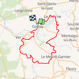
Tocht Mountainbike van 31 km beschikbaar op Normandië, Manche, Gavray-sur-Sienne. Deze tocht wordt voorgesteld door tracegps.

Beschrijving

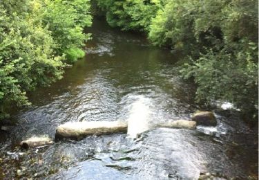
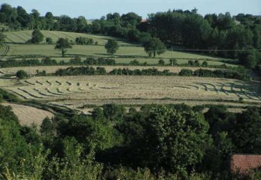
Sur ce parcoure vallonné, vous aurez le plaisir de traverser les trois principaux cours d'eau du canton de Gavray: l'Airou sur la commune de Ver, la Bérence sur la commune de Mesnil-Hue et la Sienne sur La Baleine et Gavray. Quelques montées éprouvantes par leur longueur. Beaucoup de plaisir à rouler dans les sous-bois et au bord des cours d'eau.

Hoogteprofiel

Foto's

Plaatsbepaling

Land:
France
Regio :
Normandië
Departement/Provincie :
Manche
Gemeente :
Gavray-sur-Sienne
Locatie:
Gavray
Vertrek:(Dec)
Vertrek:(UTM)
620863 ; 5418416 (30U) N.

Wandeltochten in de omgeving

Tocht Noords wandelen La Baleine - gavray 9,3 km - Photo
Noords wandelen
coglais

Noords wandelen

Heel gemakkelijk
(2)
La Baleine, Normandië, Manche, France
9,3 km | 12,1 km-effort
2h 27min
Ja
Tocht Noords wandelen La Baleine - Gavray 6 km - Photo
Noords wandelen
coglais

Noords wandelen

Heel gemakkelijk
(1)
La Baleine, Normandië, Manche, France
6 km | 8,1 km-effort
1h 56min
Ja
Tocht Noords wandelen La Baleine - Gavray 7,5 km - Photo
Noords wandelen
coglais

Noords wandelen

Heel gemakkelijk
(1)
La Baleine, Normandië, Manche, France
7,4 km | 9,8 km-effort
1h 56min
Ja
Tocht Noords wandelen La Baleine - Gavray 8,5 km - Photo
Noords wandelen
coglais

Noords wandelen

Heel gemakkelijk
(1)
La Baleine, Normandië, Manche, France
6 km | 8,1 km-effort
1h 56min
Ja
Tocht Stappen Gavray-sur-Sienne - Gavray - Circuit long - Photo
Stappen
lionelnottat

Stappen

Zeer moeilijk
(2)
Gavray-sur-Sienne, Normandië, Manche, France
16,6 km | 21 km-effort
4h 31min
Ja
Tocht Mountainbike Gavray-sur-Sienne - gavray - Photo
Mountainbike
dumbell

Mountainbike

Heel gemakkelijk
Gavray-sur-Sienne, Normandië, Manche, France
24 km | 29 km-effort
2h 31min
Ja
Tocht Mountainbike Saint-Denis-le-Gast - gavray 2  - Photo
Mountainbike
dumbell

Mountainbike

Medium
Saint-Denis-le-Gast, Normandië, Manche, France
21 km | 26 km-effort
2h 4min
Ja
Tocht Stappen Le Mesnil-Aubert - La Rue Cavée - Le Mesnil Aubert  - Photo
Stappen
tracegps

Stappen

Medium
Le Mesnil-Aubert, Normandië, Manche, France
10,1 km | 11,7 km-effort
2h 0min
Ja
Tocht Noords wandelen La Baleine - gavray 12 km - Photo
Noords wandelen
coglais

Noords wandelen

Heel gemakkelijk
(2)
La Baleine, Normandië, Manche, France
11,8 km | 15,4 km-effort
2h 27min
Ja


Sluiten
Mijn abonnementen