Tocht Stappen Gauchin-Légal - Autour du golf d'Olhain - Gauchin Légal - Photo

Autour du golf d'Olhain - Gauchin Légal

 tracegps
tracegps

Gebruiker

© OpenStreetMap contributors
Lengte
Lengte
8,1 km
Max. hoogte
Max. hoogte
192 m
Positief hoogteverschil
156 m
Km-Effort
Km-Effort  
10,2 km
Min. hoogte
Min. hoogte
85 m
Negatief hoogteverschil
156 m
Boucle
Boucle
Ja
Datum van aanmaak :
2014-12-10 00:00:00.0
Laatste wijziging :
2014-12-10 00:00:00.0

(0 Bericht)

Stappen
Stappen
2h00
Moeilijkheid : Medium

Scan deze QR-code om de tocht te openen in de SityTrail-applicatie

Gratisgps-wandelapplicatie

Logo SityTrail SityTrail

IGN / Geografische instituten

SityTrail uit de App Store downloaden SityTrail uit Google Play downloaden

Logo SityTrail SityTrail World

De wereld gaat voor u open

SityTrail uit de App Store downloaden SityTrail uit Google Play downloaden SityTrail op Huawei AppGallery downloaden

Over ons

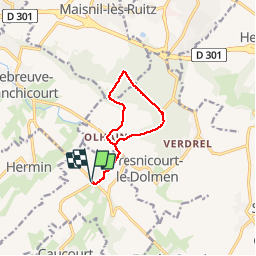
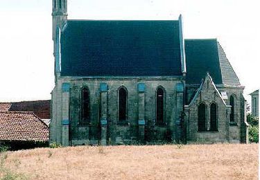
Tocht Stappen van 8,1 km beschikbaar op Hauts-de-France, Pas-de-Calais, Gauchin-Légal. Deze tocht wordt voorgesteld door tracegps.

Beschrijving

Circuit au départ de Gauchin qui fait le tour du golf d'Olhain.

Hoogteprofiel

Foto's

Plaatsbepaling

Land:
France
Regio :
Hauts-de-France
Departement/Provincie :
Pas-de-Calais
Gemeente :
Gauchin-Légal
Locatie:
Unknown
Vertrek:(Dec)
Vertrek:(UTM)
470177 ; 5584890 (31U) N.

Wandeltochten in de omgeving

Tocht Stappen Hersin-Coupigny - hersin coupigny 8 km - Photo
Stappen
temjacques

Stappen

Medium
(1)
Hersin-Coupigny, Hauts-de-France, Pas-de-Calais, France
7,8 km | 8,8 km-effort
1h 59min
Ja
Tocht Te voet Beugin - de Beugin à Bajus - Photo
Te voet
Templeuveenmarche

Te voet

Gemakkelijk
(1)
Beugin, Hauts-de-France, Pas-de-Calais, France
10,7 km | 13 km-effort
2h 10min
Ja
Tocht Andere activiteiten Houdain - Artois tour - Photo
Andere activiteiten
cnockaert

Andere activiteiten

Heel gemakkelijk
(1)
Houdain, Hauts-de-France, Pas-de-Calais, France
48 km | 59 km-effort
48min
Ja
Tocht Stappen Béthonsart - Bethonsart Caucourt Mingoval - Photo
Stappen
tracegps

Stappen

Medium
Béthonsart, Hauts-de-France, Pas-de-Calais, France
11,7 km | 13,2 km-effort
2h 30min
Ja
Tocht Stappen Houdain - Les Châtaignes d'Houdain - Photo
Stappen
tracegps

Stappen

Medium
Houdain, Hauts-de-France, Pas-de-Calais, France
7 km | 8,4 km-effort
2h 0min
Ja
Tocht Stappen Fresnicourt-le-Dolmen - La table aux  fées de Fresnicourt. (Fresnicourt-le-dolmen) - Photo
Stappen
tracegps

Stappen

Medium
(1)
Fresnicourt-le-Dolmen, Hauts-de-France, Pas-de-Calais, France
11,7 km | 14,3 km-effort
3h 0min
Ja
Tocht Stappen Villers-Châtel - Chemin de la charbonnière (Villers-Châtel)  - Photo
Stappen
tracegps

Stappen

Medium
Villers-Châtel, Hauts-de-France, Pas-de-Calais, France
11,8 km | 13,4 km-effort
3h 0min
Ja
Tocht Stappen Gauchin-Légal - Vieux cailloux et patois - Photo
Stappen
tracegps

Stappen

Moeilijk
(2)
Gauchin-Légal, Hauts-de-France, Pas-de-Calais, France
26 km | 31 km-effort
5h 30min
Ja
Tocht Stappen Cambligneul - Cambigneul - Villers Chatel - Mingoval - Caucourt - Estée Cauchy - Photo
Stappen
tracegps

Stappen

Medium
Cambligneul, Hauts-de-France, Pas-de-Calais, France
9,9 km | 11,1 km-effort
2h 0min
Ja


Sluiten
Mijn abonnementen