Tocht Stappen Toulouse - De Toulouse à Bouconne par le GR653 - Photo

De Toulouse à Bouconne par le GR653

 tracegps
tracegps

Gebruiker

© OpenStreetMap contributors
Lengte
Lengte
21 km
Max. hoogte
Max. hoogte
192 m
Positief hoogteverschil
187 m
Km-Effort
Km-Effort  
24 km
Min. hoogte
Min. hoogte
121 m
Negatief hoogteverschil
151 m
Boucle
Boucle
Neen
Datum van aanmaak :
2014-12-10 00:00:00.0
Laatste wijziging :
2014-12-10 00:00:00.0

(1 Bericht)

Stappen
Stappen
5h00
Moeilijkheid : Moeilijk

Scan deze QR-code om de tocht te openen in de SityTrail-applicatie

Gratisgps-wandelapplicatie

Logo SityTrail SityTrail

IGN / Geografische instituten

SityTrail uit de App Store downloaden SityTrail uit Google Play downloaden

Logo SityTrail SityTrail World

De wereld gaat voor u open

SityTrail uit de App Store downloaden SityTrail uit Google Play downloaden SityTrail op Huawei AppGallery downloaden

Over ons

Tocht Stappen van 21 km beschikbaar op Occitanië, Haute-Garonne, Toulouse. Deze tocht wordt voorgesteld door tracegps.

Beschrijving

Compostelle - Via Tolosana ou voie d'Arles - GR653. Sortie de Toulouse en évitant les routes à partir de la place du Capitole ou de Saint-Sernin. Elle permet de traverser Blagnac en restant sur des voies naturelles ou chemins protégés (hormis quelques courts passages). Pour les pèlerins, à partir du niveau de Cornebarrieu, reprendre le GR653 direction Pibrac et Léguevin (gîtes).

Hoogteprofiel

Foto's

Plaatsbepaling

Land:
France
Regio :
Occitanië
Departement/Provincie :
Haute-Garonne
Gemeente :
Toulouse
Locatie:
Unknown
Vertrek:(Dec)
Vertrek:(UTM)
374366 ; 4829179 (31T) N.

Opmerkingen

Gelieve in te loggen om een commentaar of een beoordeling achter te laten


Wandeltochten in de omgeving

Tocht Mountainbike L'Union - Fil Vert VTT du Grand Toulouse - Edition 2008 - 65km - Photo
Mountainbike
tracegps

Mountainbike

Moeilijk
(1)
L'Union, Occitanië, Haute-Garonne, France
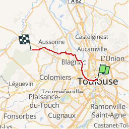
66 km | 72 km-effort
4h 30min
Ja
Tocht Fiets Toulouse - Canal du Midi - Photo
Fiets
frizou83

Fiets

Heel gemakkelijk
(1)
Toulouse, Occitanië, Haute-Garonne, France
259 km | 281 km-effort
15h 55min
Neen
Tocht Stappen Toulouse - Tour de Toulouse par la Garonne  - Photo
Stappen
CooolGeorges

Stappen

Medium
Toulouse, Occitanië, Haute-Garonne, France
9,3 km | 11 km-effort
2h 35min
Ja
Tocht Stappen Toulouse - Toulouse - Pinsaguel  - Photo
Stappen
zazibelle

Stappen

Gemakkelijk
(1)
Toulouse, Occitanië, Haute-Garonne, France
15,6 km | 17,5 km-effort
4h 59min
Neen
Tocht Stappen Blagnac - Blagnac, le long de la Garonne  - Photo
Stappen
phil88

Stappen

Gemakkelijk
Blagnac, Occitanië, Haute-Garonne, France
5,3 km | 5,9 km-effort
1h 48min
Ja
Tocht Fiets Toulouse - Canal du Midi - Etape 1 - Photo
Fiets
frizou83

Fiets

Heel gemakkelijk
Toulouse, Occitanië, Haute-Garonne, France
55 km | 61 km-effort
3h 28min
Neen
Tocht Stappen Toulouse - Rive Droite Garonne Toulouse Gagnac - Photo
Stappen
RR31

Stappen

Gemakkelijk
Toulouse, Occitanië, Haute-Garonne, France
24 km | 27 km-effort
5h 55min
Neen
Tocht Stappen Toulouse - Rive Droite Garonne Toulouse Gagnac - Photo
Stappen
RR31

Stappen

Gemakkelijk
Toulouse, Occitanië, Haute-Garonne, France
24 km | 27 km-effort
5h 55min
Neen
Tocht Mountainbike L'Union - Fil Vert VTT du Grand Toulouse - Edition 2008 - 37km - Photo
Mountainbike
tracegps

Mountainbike

Medium
L'Union, Occitanië, Haute-Garonne, France
37 km | 40 km-effort
3h 0min
Ja


Sluiten
Mijn abonnementen