Tocht Stappen Auberive - MJW 5-2 - Photo
 hubbi
hubbi

Gebruiker

© OpenStreetMap contributors
Lengte
Lengte
16,1 km
Max. hoogte
Max. hoogte
495 m
Positief hoogteverschil
328 m
Km-Effort
Km-Effort  
20 km
Min. hoogte
Min. hoogte
333 m
Negatief hoogteverschil
224 m
Boucle
Boucle
Neen
Datum van aanmaak :
2014-12-10 00:00:00.0
Laatste wijziging :
2014-12-10 00:00:00.0

(0 Bericht)

Stappen
Stappen
4h23
Moeilijkheid : Gemakkelijk

Scan deze QR-code om de tocht te openen in de SityTrail-applicatie

Gratisgps-wandelapplicatie

Logo SityTrail SityTrail

IGN / Geografische instituten

SityTrail uit de App Store downloaden SityTrail uit Google Play downloaden

Logo SityTrail SityTrail World

De wereld gaat voor u open

SityTrail uit de App Store downloaden SityTrail uit Google Play downloaden SityTrail op Huawei AppGallery downloaden

Over ons

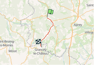
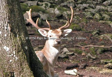
Tocht Stappen van 16,1 km beschikbaar op Grand Est, Haute-Marne, Auberive. Deze tocht wordt voorgesteld door hubbi.

Beschrijving

Auberive - Grancey-le-Château

Hoogteprofiel

Plaatsbepaling

Land:
France
Regio :
Grand Est
Departement/Provincie :
Haute-Marne
Gemeente :
Auberive
Locatie:
Unknown
Vertrek:(Dec)
Vertrek:(UTM)
654335 ; 5294985 (31T) N.

Wandeltochten in de omgeving

Tocht Fiets Auberive - La Montagne - Auberive - Photo
Fiets
tracegps

Fiets

Moeilijk
Auberive, Grand Est, Haute-Marne, France
65 km | 80 km-effort
6h 0min
Ja
Tocht Stappen Auberive - Sentier Vosges-Pyrénées - de Auberive à Grancey le Château - Photo
Stappen
tracegps

Stappen

Moeilijk
Auberive, Grand Est, Haute-Marne, France
18,7 km | 25 km-effort
5h 0min
Neen
Tocht Mountainbike Auberive - Le Pont Griselin - Auberive - Photo
Mountainbike
tracegps

Mountainbike

Gemakkelijk
Auberive, Grand Est, Haute-Marne, France
3,3 km | 3,8 km-effort
19min
Ja
Tocht Stappen Auberive - Le Pont Griselin - Auberive - Photo
Stappen
tracegps

Stappen

Zeer moeilijk
Auberive, Grand Est, Haute-Marne, France
3,3 km | 3,8 km-effort
1h 0min
Ja
Tocht Mountainbike Auberive - Circuit de Montavoir - Auberive - Photo
Mountainbike
tracegps

Mountainbike

Gemakkelijk
Auberive, Grand Est, Haute-Marne, France
9,1 km | 11,3 km-effort
45min
Ja
Tocht Stappen Auberive - Circuit de Montavoir - Auberive - Photo
Stappen
tracegps

Stappen

Gemakkelijk
Auberive, Grand Est, Haute-Marne, France
9,1 km | 11,3 km-effort
1h 19min
Ja
Tocht Mountainbike Auberive - La Tufière d'Amorey - Auberive - Photo
Mountainbike
tracegps

Mountainbike

Gemakkelijk
Auberive, Grand Est, Haute-Marne, France
10,6 km | 14,2 km-effort
1h 0min
Ja
Tocht Stappen Auberive - La Tufière d'Amorey - Auberive - Photo
Stappen
tracegps

Stappen

Gemakkelijk
Auberive, Grand Est, Haute-Marne, France
10,6 km | 14,2 km-effort
2h 0min
Ja
Tocht Mountainbike Bay-sur-Aube - La Butte de Taloison - Bay sur Aube - Photo
Mountainbike
tracegps

Mountainbike

Gemakkelijk
Bay-sur-Aube, Grand Est, Haute-Marne, France
8 km | 11 km-effort
45min
Ja


Sluiten
Mijn abonnementen