Tocht Stappen Plan-d'Aups-Sainte-Baume - Plan d'Aups col de Bertagne Gpe 1 - Photo
 Elidabeth
Elidabeth

Gebruiker

© OpenStreetMap contributors
Lengte
Lengte
11 km
Max. hoogte
Max. hoogte
914 m
Positief hoogteverschil
410 m
Km-Effort
Km-Effort  
16,5 km
Min. hoogte
Min. hoogte
661 m
Negatief hoogteverschil
413 m
Boucle
Boucle
Ja
Datum van aanmaak :
2014-12-10 00:00:00.0
Laatste wijziging :
2014-12-10 00:00:00.0

(0 Bericht)

Stappen
Stappen
--
Moeilijkheid : Medium

Scan deze QR-code om de tocht te openen in de SityTrail-applicatie

Gratisgps-wandelapplicatie

Logo SityTrail SityTrail

IGN / Geografische instituten

SityTrail uit de App Store downloaden SityTrail uit Google Play downloaden

Logo SityTrail SityTrail World

De wereld gaat voor u open

SityTrail uit de App Store downloaden SityTrail uit Google Play downloaden SityTrail op Huawei AppGallery downloaden

Over ons

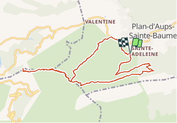
Tocht Stappen van 11 km beschikbaar op Provence-Alpes-Côte d'Azur, Var, Plan-d'Aups-Sainte-Baume. Deze tocht wordt voorgesteld door Elidabeth.

Hoogteprofiel

POI's

POI Plan-d'Aups-Sainte-Baume - OR-2044801:Plan d'Aups col de Bertagne le plan des Vaches Gp1 11.033  - Photo
Elidabeth
PLAN-D'AUPS-SAINTE-BAUME 

Plaatsbepaling

Land:
France
Regio :
Provence-Alpes-Côte d'Azur
Departement/Provincie :
Var
Gemeente :
Plan-d'Aups-Sainte-Baume
Locatie:
Unknown
Vertrek:(Dec)
Vertrek:(UTM)
719462 ; 4800302 (31T) N.

Wandeltochten in de omgeving

Tocht Stappen Plan-d'Aups-Sainte-Baume - Sainte Baume 8,5 km - Photo
Stappen
GUIDE
rvapeldo

Stappen

Medium
(1)
Plan-d'Aups-Sainte-Baume, Provence-Alpes-Côte d'Azur, Var, France
8,4 km | 15,5 km-effort
4h 38min
Ja
Tocht Stappen Plan-d'Aups-Sainte-Baume - SityTrail - Sentier merveilleux - La Ste baume - Le Plan d'aups  - Photo
Stappen
GUIDE
affinetataille

Stappen

Medium
(1)
Plan-d'Aups-Sainte-Baume, Provence-Alpes-Côte d'Azur, Var, France
15 km | 23 km-effort
6h 0min
Ja
Tocht Stappen Gémenos - dent de roque forcade. cauvin.bertagne. 2 avril 2018 - Photo
Stappen
marchev

Stappen

Medium
(1)
Gémenos, Provence-Alpes-Côte d'Azur, Bouches-du-Rhône, France
12,7 km | 20 km-effort
4h 31min
Ja
Tocht Stappen Auriol - la crete des infernets - Photo
Stappen
Coryphene

Stappen

Moeilijk
(1)
Auriol, Provence-Alpes-Côte d'Azur, Bouches-du-Rhône, France
8,6 km | 14 km-effort
3h 22min
Ja
Tocht Stappen Plan-d'Aups-Sainte-Baume - Crêts de la Ste Baume - Photo
Stappen
tracegps

Stappen

Medium
(2)
Plan-d'Aups-Sainte-Baume, Provence-Alpes-Côte d'Azur, Var, France
15,4 km | 23 km-effort
5h 0min
Ja
Tocht Stappen Gémenos - Autour des Dents de Roque Forcade, Tour de Cauvin - Photo
Stappen
tracegps

Stappen

Moeilijk
(1)
Gémenos, Provence-Alpes-Côte d'Azur, Bouches-du-Rhône, France
7,6 km | 11,7 km-effort
3h 15min
Ja
Tocht Stappen Plan-d'Aups-Sainte-Baume - Du Col du Saint-Pilon au Pas de l'Aï, Sainte Baume - Photo
Stappen
tracegps

Stappen

Medium
(1)
Plan-d'Aups-Sainte-Baume, Provence-Alpes-Côte d'Azur, Var, France
13,1 km | 20 km-effort
5h 15min
Ja
Tocht Stappen Riboux - Riboux - Forêt de Malaucène - Photo
Stappen
tracegps

Stappen

Medium
(4)
Riboux, Provence-Alpes-Côte d'Azur, Var, France
12,2 km | 15,2 km-effort
2h 40min
Ja
Tocht Stappen Plan-d'Aups-Sainte-Baume - La Grotte aux oiseaux - Plan d'Aups  - Photo
Stappen
tracegps

Stappen

Medium
(1)
Plan-d'Aups-Sainte-Baume, Provence-Alpes-Côte d'Azur, Var, France
8,8 km | 12,5 km-effort
2h 30min
Ja


Sluiten
Mijn abonnementen