![](/images/other/stat-length.png)
![Tocht Stappen Eigenbrakel - RB-Bw-13_Braine-l'Alleud - Photo](https://media.geolcdn.com/t/1900/400/ext.pjpeg?maxdim=2&url=https%3A%2F%2Fservices.sitytrail.com%2FGeolivesWS%2FDownloadMedia.ashx%3FTrailID%3D179588%26Media%3D9ffdd7b7-2039-4356-b235-ee33d9a18bd7.jpg)
RB-Bw-13_Braine-l'Alleud
GR Rando
Randonnez sur et autour des GR ® wallons (Sentiers de Grande Randonnée). PRO
![Lengte](/images/other/stat-length.png)
![Max. hoogte](https://static1.geolcdn.com/siteimages/upload/files/1508320355ic_sort_altitude_max_24dp.png)
![Positief hoogteverschil](https://static1.geolcdn.com/siteimages/upload/files/1508320355ic_sort_den_pos_24dp.png)
![Km-Effort](/images/other/stat-length.png)
![Min. hoogte](https://static1.geolcdn.com/siteimages/upload/files/1508320355ic_sort_altitude_min_24dp.png)
![Negatief hoogteverschil](https://static1.geolcdn.com/siteimages/upload/files/1508320355ic_sort_den_neg_24dp.png)
![Boucle](https://static1.geolcdn.com/siteimages/upload/files/16400158638029165_repeat_loop_refresh_sync_direction_icon.png)
![Stappen](https://static1.geolcdn.com/sitytour/trail-icons/101.png)
6h02
Moeilijkheid : Zeer moeilijk
![Scan deze QR-code om de tocht te openen in de SityTrail-applicatie](https://capi.geolives.com/qq0zvz2zws4bq2lad0pu/sitytour/trails/179588/qr.png?size=200)
Gratisgps-wandelapplicatie
Over ons
Tocht Stappen van 21 km beschikbaar op Wallonië, Waals-Brabant, Eigenbrakel. Deze tocht wordt voorgesteld door GR Rando.
Beschrijving
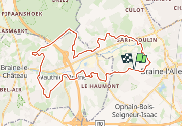
Braine-l’Alleud, Wauthier-Braine, Braine-l’Alleud
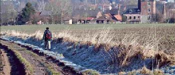
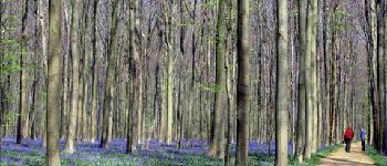
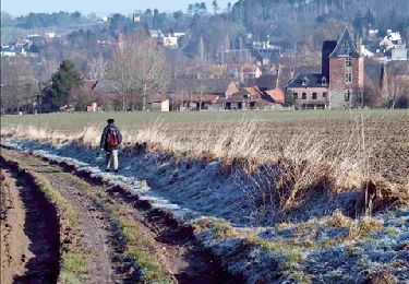
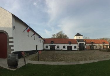
Si vous connaissez un peu la région, la vallée du Hain, entre Braine-l’Alleud et
Braine-le-Château, c’est une succession de zonings industriels, sillonnés par des artères sans beaucoup d’âme, au trafic incessant, et un affreux viaduc
d’autoroute. Mais ceux qui connaissent fort bien ce coin savent que cet aspect ne concerne jamais qu’une bande de territoire d’à peine quelques centaines de mètres de largeur et qu’il existe, sur les collines qui bordent ce vallon, des tas de chemins tranquilles, de bois, de campagnes, de sites charmants. Les amis qui ont conçu cette randonnée connaissent le moindre coin de cette terre – leur terre– et ils se sont appliqués à nous la faire découvrir sous son meilleur jour. Surtout, ne boudons pas notre plaisir
Cartographie et documentation
Cartes IGN au 1 :20 000, 39/1-2 « Rebecq – Ittre » et 39/3-4 « Waterloo – La Hulpe ».
Topo-guide des GR 12 « Amsterdam – Bruxelles – Paris » et 121 « Wavre –
Boulogne-sur-Mer ».
Où se désaltérer et se restaurer
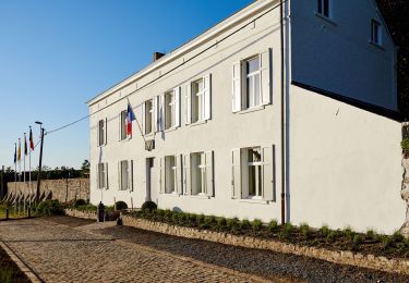
À Braine-l’Alleud, une multitude de commerces, de cafés et de restaurants vous
donnent l’embarras du choix.
Sur la grand-place de Wauthier-Braine, le café « L’Olivier » est ouvert tous les jours, sauf le dimanche.
Plaatsbepaling
Opmerkingen
Wandeltochten in de omgeving
![Tocht Stappen Eigenbrakel - RB-Bw-13 - Raccourci - Le Hain entre deux Braines - Photo](https://media.geolcdn.com/t/375/260/ext.jpg?maxdim=2&url=https%3A%2F%2Fservices.sitytrail.com%2FGeolivesWS%2FDownloadMedia.ashx%3FTrailID%3D220430%26Media%3D9ffdd7b7-2039-4356-b235-ee33d9a18bd7.jpg)
![Stappen Stappen](https://static1.geolcdn.com/sitytour/trail-icons/101.png)
Stappen
![](/images/other/stat-length.png)
![](https://static1.geolcdn.com/siteimages/upload/files/16400158638029165_repeat_loop_refresh_sync_direction_icon.png)
![Tocht Mountainbike Eigenbrakel - O2bikers_58_Waterloo - Photo](https://media.geolcdn.com/t/375/260/ext.jpg?maxdim=2&url=https%3A%2F%2Fstatic1.geolcdn.com%2Fsiteimages%2Fupload%2Ffiles%2F1524743154velo.jpg)
![Mountainbike Mountainbike](https://static1.geolcdn.com/sitytour/trail-icons/202.png)
Mountainbike
![](/images/other/stat-length.png)
![](https://static1.geolcdn.com/siteimages/upload/files/16400158638029165_repeat_loop_refresh_sync_direction_icon.png)
![Tocht Mountainbike Waterloo - De Waterloo à la forêt de Soignes - Photo](https://media.geolcdn.com/t/375/260/ext.jpg?maxdim=2&url=https%3A%2F%2Fservices.sitytrail.com%2FGeolivesWS%2FDownloadMedia.ashx%3FTrailID%3D688453%26Media%3D31ac41f9-68d5-4a4a-9a8e-a882e9787769.JPG)
![Mountainbike Mountainbike](https://static1.geolcdn.com/sitytour/trail-icons/202.png)
Mountainbike
![](/images/other/stat-length.png)
![](https://static1.geolcdn.com/siteimages/upload/files/16400158638029165_repeat_loop_refresh_sync_direction_icon.png)
![Tocht Stappen Halle - Balade dans le Bois de Halle - Photo](https://media.geolcdn.com/t/375/260/ext.jpg?maxdim=2&url=https%3A%2F%2Fservices.sitytrail.com%2FGeolivesWS%2FDownloadMedia.ashx%3FTrailID%3D411974%26Media%3D4cfcce27-edaf-4211-9dbe-1277fff36f47.JPG)
![Stappen Stappen](https://static1.geolcdn.com/sitytour/trail-icons/101.png)
Stappen
![](/images/other/stat-length.png)
![](https://static1.geolcdn.com/siteimages/upload/files/16400158638029165_repeat_loop_refresh_sync_direction_icon.png)
![Tocht Stappen Eigenbrakel - #221003 - Braine-l'Alleud, Timpe et Tard et Bois du Foriest, Parc et Lac du Paradis*** - Photo](https://media.geolcdn.com/t/375/260/ext.jpg?maxdim=2&url=https%3A%2F%2Fmedia.geolcdn.com%2Ff%2F7ca9587d-0fe0-4627-96a6-2d18fe7f584a.jpg)
![Stappen Stappen](https://static1.geolcdn.com/sitytour/trail-icons/101.png)
Stappen
![](/images/other/stat-length.png)
![](https://static1.geolcdn.com/siteimages/upload/files/16400158638029165_repeat_loop_refresh_sync_direction_icon.png)
![Tocht Fiets Waterloo - Du Domaine Solvay (Château de La Hulpe + Fondation Folon) à la Butte du Lion - Photo](https://media.geolcdn.com/t/375/260/ext.jpg?maxdim=2&url=https%3A%2F%2Fmedia.geolcdn.com%2Ff%2F6e2b14e5-7f01-4b82-86ec-767250ffcdcd.jpg)
![Fiets Fiets](https://static1.geolcdn.com/sitytour/trail-icons/200.png)
Fiets
![](/images/other/stat-length.png)
![](https://static1.geolcdn.com/siteimages/upload/files/16400158638029165_repeat_loop_refresh_sync_direction_icon.png)
![Tocht Stappen Eigenbrakel - Promenade 1815 - Photo](https://media.geolcdn.com/t/375/260/ext.jpg?maxdim=2&url=https%3A%2F%2Fmedia.geolcdn.com%2Ff%2Fa5c88808-562a-4352-bf02-99aedd3ac634.jpg)
![Stappen Stappen](https://static1.geolcdn.com/sitytour/trail-icons/101.png)
Stappen
![](/images/other/stat-length.png)
![](https://static1.geolcdn.com/siteimages/upload/files/16400158638029165_repeat_loop_refresh_sync_direction_icon.png)
![Tocht Stappen Eigenbrakel - Entre l'Ermite et Odeghien - Photo](https://media.geolcdn.com/t/375/260/ext.jpg?maxdim=2&url=https%3A%2F%2Fservices.sitytrail.com%2FGeolivesWS%2FDownloadMedia.ashx%3FTrailID%3D338686%26Media%3D20140824140258.jpg)
![Stappen Stappen](https://static1.geolcdn.com/sitytour/trail-icons/101.png)
Stappen
![](/images/other/stat-length.png)
![](https://static1.geolcdn.com/siteimages/upload/files/16400158638029165_repeat_loop_refresh_sync_direction_icon.png)
![Tocht Stappen Halle - bois de halle hallerbos - Photo](https://media.geolcdn.com/t/375/260/ext.jpg?maxdim=2&url=https%3A%2F%2Fmedia.geolcdn.com%2Ff%2F171c7fd8-9c79-49a4-b4c2-e78fc47fb1c7.jpg)
![Stappen Stappen](https://static1.geolcdn.com/sitytour/trail-icons/101.png)
Stappen
![](/images/other/stat-length.png)
![](https://static1.geolcdn.com/siteimages/upload/files/16400158638029165_repeat_loop_refresh_sync_direction_icon.png)
Sympa