Tocht Mountainbike Périers - Randonnée autour de Périers - Photo

Randonnée autour de Périers

 tracegps
tracegps

Gebruiker

© OpenStreetMap contributors
Lengte
Lengte
32 km
Max. hoogte
Max. hoogte
43 m
Positief hoogteverschil
216 m
Km-Effort
Km-Effort  
35 km
Min. hoogte
Min. hoogte
5 m
Negatief hoogteverschil
217 m
Boucle
Boucle
Ja
Datum van aanmaak :
2014-12-10 00:00:00.0
Laatste wijziging :
2014-12-10 00:00:00.0

(1 Bericht)

Mountainbike
Mountainbike
2h00
Moeilijkheid : Gemakkelijk

Scan deze QR-code om de tocht te openen in de SityTrail-applicatie

Gratisgps-wandelapplicatie

Logo SityTrail SityTrail

IGN / Geografische instituten

SityTrail uit de App Store downloaden SityTrail uit Google Play downloaden

Logo SityTrail SityTrail World

De wereld gaat voor u open

SityTrail uit de App Store downloaden SityTrail uit Google Play downloaden SityTrail op Huawei AppGallery downloaden

Over ons

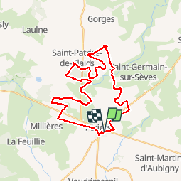
Tocht Mountainbike van 32 km beschikbaar op Normandië, Manche, Périers. Deze tocht wordt voorgesteld door tracegps.

Beschrijving

Périers se situe dans le centre Manche, à la limite des Marais du Cotentin. Circuit sans aucune difficultés, très souvent on se trouve sur d'anciennes voies romaines et voie verte.

Hoogteprofiel

Foto's

Plaatsbepaling

Land:
France
Regio :
Normandië
Departement/Provincie :
Manche
Gemeente :
Périers
Locatie:
Unknown
Vertrek:(Dec)
Vertrek:(UTM)
616331 ; 5449272 (30U) N.

Opmerkingen

Gelieve in te loggen om een commentaar of een beoordeling achter te laten


Wandeltochten in de omgeving

Tocht Stappen Millières - Lac f - Photo
Stappen
Yvon59

Stappen

Medium
Millières, Normandië, Manche, France
8,2 km | 8,9 km-effort
2h 55min
Ja
Tocht Andere activiteiten Périers - St Martin d'Aubigny - Marchesieux  - Photo
Andere activiteiten
stephbab1

Andere activiteiten

Gemakkelijk
Périers, Normandië, Manche, France
30 km | 32 km-effort
1h 52min
Ja
Tocht Andere activiteiten Périers - St Martin d'Aubigny - Marchesieux  - Photo
Andere activiteiten
stephbab1

Andere activiteiten

Gemakkelijk
Périers, Normandië, Manche, France
30 km | 32 km-effort
1h 52min
Ja
Tocht Mountainbike Périers - Manche 3 - Photo
Mountainbike
plevier

Mountainbike

Heel gemakkelijk
Périers, Normandië, Manche, France
48 km | 55 km-effort
11h 52min
Neen
Tocht Stappen Millières - Lande de Millières lac des bruyères - Photo
Stappen
Climatis50

Stappen

Gemakkelijk
Millières, Normandië, Manche, France
7,3 km | 8,1 km-effort
1h 48min
Ja
Tocht Stappen Millières - 2018-09-25 Milieres  - Photo
Stappen
Climatis50

Stappen

Heel gemakkelijk
Millières, Normandië, Manche, France
6,7 km | 7,4 km-effort
1h 38min
Ja
Tocht Stappen Périers - PERIERS COUTANCES - Photo
Stappen
UDGI54

Stappen

Heel gemakkelijk
Périers, Normandië, Manche, France
19,6 km | 23 km-effort
4h 59min
Neen
Tocht Stappen Saint-Martin-d'Aubigny - st mart aub/houesville - Photo
Stappen
Michel50

Stappen

Heel gemakkelijk
Saint-Martin-d'Aubigny, Normandië, Manche, France
29 km | 31 km-effort
7h 26min
Neen


Sluiten
Mijn abonnementen