Transsouillagaise 2013 - Souillac
tracegps
Gebruiker
Lengte
39 km
Max. hoogte
298 m
Positief hoogteverschil
898 m
Km-Effort
51 km
Min. hoogte
83 m
Negatief hoogteverschil
898 m
Boucle
Ja
Datum van aanmaak :
2014-12-10 00:00:00.0
Laatste wijziging :
2014-12-10 00:00:00.0
3h30
Moeilijkheid : Zeer moeilijk
Gratisgps-wandelapplicatie
Over ons
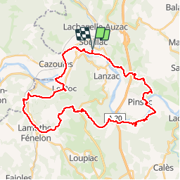
Tocht Mountainbike van 39 km beschikbaar op Occitanië, Lot, Souillac. Deze tocht wordt voorgesteld door tracegps.
Beschrijving
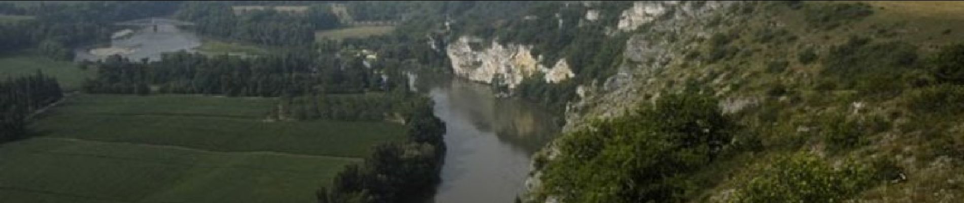
Départ du stade de Souillac, direction le centre ville, et ensuite une montée sur les coteaux au dessus de la Dordogne. Parcours sur chemins caillouteux et peu roulants.
Plaatsbepaling
Land:
France
Regio :
Occitanië
Departement/Provincie :
Lot
Gemeente :
Souillac
Locatie:
Unknown
Vertrek:(Dec)
Vertrek:(UTM)
379136 ; 4972102 (31T) N.
Opmerkingen
Wandeltochten in de omgeving
La balade du Mas Soubrot
Stappen
Medium
Lachapelle-Auzac,
Occitanië,
Lot,
France
4,5 km | 6,6 km-effort
1h 22min
Ja
Trail chemin d'Enzo
Lopen
Medium
(1)
Souillac,
Occitanië,
Lot,
France
12,8 km | 16,9 km-effort
1h 24min
Ja
souillac bord de la dordogne
Stappen
Heel gemakkelijk
(2)
Souillac,
Occitanië,
Lot,
France
7,9 km | 9,8 km-effort
2h 13min
Ja
Souillac_Viaduc
Stappen
Medium
Souillac,
Occitanië,
Lot,
France
12,6 km | 16,3 km-effort
3h 45min
Ja
Souillac_Autour
Stappen
Gemakkelijk
Souillac,
Occitanië,
Lot,
France
8,1 km | 9,9 km-effort
2h 30min
Ja
VALLÉE DE LA DORDOGNE- EST DEPUIS CALVIAC EN PÉRIGORD
Wegfiets
Moeilijk
Cazoulès,
Nieuw-Aquitanië,
Dordogne,
France
73 km | 91 km-effort
6h 55min
Neen
Souillac-St Cirq-Vallée du Célé-St Céré-Carennac-Turenne
Motorfiets
Gemakkelijk
Souillac,
Occitanië,
Lot,
France
224 km | 273 km-effort
5h 0min
Neen
rouffillac - souillac sud part 2
Stappen
Heel gemakkelijk
Lanzac,
Occitanië,
Lot,
France
4,8 km | 5,5 km-effort
1h 3min
Neen
hauts de Cazoules
Stappen
Medium
Cazoulès,
Nieuw-Aquitanië,
Dordogne,
France
17,4 km | 24 km-effort
9h 14min
Ja