Tocht Stappen Pamproux - Circuit de la feuille de vigne - Photo

Circuit de la feuille de vigne

 dan79
dan79

Gebruiker

© OpenStreetMap contributors
Lengte
Lengte
11 km
Max. hoogte
Max. hoogte
115 m
Positief hoogteverschil
123 m
Km-Effort
Km-Effort  
12,6 km
Min. hoogte
Min. hoogte
82 m
Negatief hoogteverschil
122 m
Boucle
Boucle
Ja
Datum van aanmaak :
2014-12-10 00:00:00.0
Laatste wijziging :
2014-12-10 00:00:00.0

(0 Bericht)

Stappen
Stappen
2h47
Moeilijkheid : Gemakkelijk

Scan deze QR-code om de tocht te openen in de SityTrail-applicatie

Gratisgps-wandelapplicatie

Logo SityTrail SityTrail

IGN / Geografische instituten

SityTrail uit de App Store downloaden SityTrail uit Google Play downloaden

Logo SityTrail SityTrail World

De wereld gaat voor u open

SityTrail uit de App Store downloaden SityTrail uit Google Play downloaden SityTrail op Huawei AppGallery downloaden

Over ons

Tocht Stappen van 11 km beschikbaar op Nieuw-Aquitanië, Deux-Sèvres, Pamproux. Deze tocht wordt voorgesteld door dan79.

Beschrijving

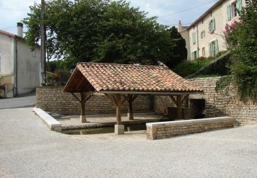
Circuit proposé par la commune de Pamproux .

Départ de l’église de Pamproux.

Hoogteprofiel

Plaatsbepaling

Land:
France
Regio :
Nieuw-Aquitanië
Departement/Provincie :
Deux-Sèvres
Gemeente :
Pamproux
Locatie:
Unknown
Vertrek:(Dec)
Vertrek:(UTM)
726248 ; 5142142 (30T) N.

Wandeltochten in de omgeving

Tocht Stappen Pamproux - Circuit de La roche ruffin à la Liborlière  - Pamproux - Photo
Stappen
tracegps

Stappen

Medium
Pamproux, Nieuw-Aquitanië, Deux-Sèvres, France
9,4 km | 10,9 km-effort
2h 25min
Ja
Tocht Stappen Pamproux - Circuit de la feuille de vigne - Pamproux - Photo
Stappen
tracegps

Stappen

Medium
Pamproux, Nieuw-Aquitanië, Deux-Sèvres, France
11 km | 12,6 km-effort
2h 45min
Ja
Tocht Stappen Pamproux - Circuit de La roche ruffin à la Liborlière - Photo
Stappen
dan79

Stappen

Heel gemakkelijk
Pamproux, Nieuw-Aquitanië, Deux-Sèvres, France
9,4 km | 10,9 km-effort
2h 25min
Ja
Tocht Mountainbike La Mothe-Saint-Héray - Zevtt - My La Mothe St Héray - Photo
Mountainbike
kipoura

Mountainbike

Moeilijk
La Mothe-Saint-Héray, Nieuw-Aquitanië, Deux-Sèvres, France
54 km | 66 km-effort
3h 30min
Ja
Tocht Mountainbike La Mothe-Saint-Héray - Zevtt - La Mothe St Héray VTT 41km - Photo
Mountainbike
kipoura

Mountainbike

Medium
La Mothe-Saint-Héray, Nieuw-Aquitanië, Deux-Sèvres, France
41 km | 51 km-effort
2h 30min
Ja
Tocht Stappen La Mothe-Saint-Héray - 202405-12 - Photo
Stappen
JO Dessinmekss

Stappen

Gemakkelijk
La Mothe-Saint-Héray, Nieuw-Aquitanië, Deux-Sèvres, France
4 km | 4,3 km-effort
57min
Neen
Tocht Stappen La Mothe-Saint-Héray - 2022-08-12 La Dame de Chambrille - Photo
Stappen
cagouille79

Stappen

Medium
La Mothe-Saint-Héray, Nieuw-Aquitanië, Deux-Sèvres, France
9,3 km | 11,1 km-effort
2h 31min
Ja
Tocht Stappen Bougon - 79 BOUGON La Pierre Levée - Photo
Stappen
maioy

Stappen

Gemakkelijk
Bougon, Nieuw-Aquitanië, Deux-Sèvres, France
11,8 km | 13,4 km-effort
2h 56min
Ja
Tocht Stappen La Mothe-Saint-Héray - 202405-12  bis - Photo
Stappen
JO Dessinmekss

Stappen

Gemakkelijk
La Mothe-Saint-Héray, Nieuw-Aquitanië, Deux-Sèvres, France
846 m | 869 m-effort
11min
Neen


Sluiten
Mijn abonnementen