Tocht Elektrische fiets Saint-Maurice-lès-Couches - Couches-Cheilly-Creot_2018-09-05 - Photo
 verleihnix
verleihnix

Gebruiker

© OpenStreetMap contributors
Lengte
Lengte
32 km
Max. hoogte
Max. hoogte
392 m
Positief hoogteverschil
374 m
Km-Effort
Km-Effort  
37 km
Min. hoogte
Min. hoogte
223 m
Negatief hoogteverschil
366 m
Boucle
Boucle
Neen
Datum van aanmaak :
2019-03-07 17:55:13.246
Laatste wijziging :
2019-03-08 06:58:06.55

(0 Bericht)

Elektrische fiets
Elektrische fiets
--
Moeilijkheid : Gemakkelijk

Scan deze QR-code om de tocht te openen in de SityTrail-applicatie

Gratisgps-wandelapplicatie

Logo SityTrail SityTrail

IGN / Geografische instituten

SityTrail uit de App Store downloaden SityTrail uit Google Play downloaden

Logo SityTrail SityTrail World

De wereld gaat voor u open

SityTrail uit de App Store downloaden SityTrail uit Google Play downloaden SityTrail op Huawei AppGallery downloaden

Over ons

Tocht Elektrische fiets van 32 km beschikbaar op Bourgondië-Franche-Comté, Saône-et-Loire, Saint-Maurice-lès-Couches. Deze tocht wordt voorgesteld door verleihnix.

Beschrijving

Created by Verleihnix

Hoogteprofiel

Plaatsbepaling

Land:
France
Regio :
Bourgondië-Franche-Comté
Departement/Provincie :
Saône-et-Loire
Gemeente :
Saint-Maurice-lès-Couches
Locatie:
Unknown
Vertrek:(UTM)
622634 ; 5191817 (31T) N.

Wandeltochten in de omgeving

Tocht Stappen Saint-Maurice-lès-Couches - Saint Maurice les Couches  GRS (gde) - Photo
Stappen
Malice0093

Stappen

Moeilijk
(1)
Saint-Maurice-lès-Couches, Bourgondië-Franche-Comté, Saône-et-Loire, France
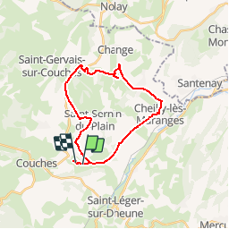
11,5 km | 15,3 km-effort
3h 29min
Ja
Tocht Stappen Charrecey - Charrecey Le Montabon  page 29 - Photo
Stappen
grasgilbert

Stappen

Moeilijk
(2)
Charrecey, Bourgondië-Franche-Comté, Saône-et-Loire, France
12,9 km | 18 km-effort
3h 59min
Ja
Tocht Te voet Saint-Jean-de-Trézy - Saint Jean de Trézy - Photo
Te voet
Malice0093

Te voet

Gemakkelijk
(1)
Saint-Jean-de-Trézy, Bourgondië-Franche-Comté, Saône-et-Loire, France
11,3 km | 13,9 km-effort
3h 8min
Ja
Tocht Stappen Saint-Sernin-du-Plain - Mazenay les deux monts page 17 - Photo
Stappen
grasgilbert

Stappen

Zeer moeilijk
(1)
Saint-Sernin-du-Plain, Bourgondië-Franche-Comté, Saône-et-Loire, France
13,5 km | 19,4 km-effort
4h 24min
Ja
Tocht Stappen Sampigny-lès-Maranges - Sampigny les maranges  - Photo
Stappen
grasgilbert

Stappen

Moeilijk
(4)
Sampigny-lès-Maranges, Bourgondië-Franche-Comté, Saône-et-Loire, France
12,6 km | 17 km-effort
3h 51min
Ja
Tocht Stappen Couches - couches saint jean de trézy - Photo
Stappen
patourad

Stappen

Gemakkelijk
(1)
Couches, Bourgondië-Franche-Comté, Saône-et-Loire, France
11 km | 14,4 km-effort
3h 3min
Ja
Tocht Stappen Saint-Léger-sur-Dheune - Circuit n°1 de Saint Leger sur Dheune - Photo
Stappen
tracegps

Stappen

Gemakkelijk
Saint-Léger-sur-Dheune, Bourgondië-Franche-Comté, Saône-et-Loire, France
8 km | 10,2 km-effort
2h 0min
Ja
Tocht Mountainbike Dennevy - Bourges (18) - Breurey lès Faverney (70) - Etape 4/6 - De Dennevy à Echigey - Photo
Mountainbike
tracegps

Mountainbike

Medium
Dennevy, Bourgondië-Franche-Comté, Saône-et-Loire, France
80 km | 88 km-effort
6h 0min
Neen
Tocht Te voet Dracy-lès-Couches - Les Balcons de Dracy - Photo
Te voet
PRO

Te voet

Gemakkelijk
Dracy-lès-Couches, Bourgondië-Franche-Comté, Saône-et-Loire, France
7,4 km | 9,2 km-effort
2h 5min
Ja


Sluiten
Mijn abonnementen