Tocht Stappen Senantes - Senantes - Photo
 jpblimond
jpblimond

Gebruiker

© OpenStreetMap contributors
Lengte
Lengte
18,7 km
Max. hoogte
Max. hoogte
207 m
Positief hoogteverschil
296 m
Km-Effort
Km-Effort  
23 km
Min. hoogte
Min. hoogte
111 m
Negatief hoogteverschil
294 m
Boucle
Boucle
Ja
Datum van aanmaak :
2019-04-22 11:05:30.472
Laatste wijziging :
2019-04-27 16:49:30.489

(0 Bericht)

Stappen
Stappen
4h47
Moeilijkheid : Medium

Scan deze QR-code om de tocht te openen in de SityTrail-applicatie

Gratisgps-wandelapplicatie

Logo SityTrail SityTrail

IGN / Geografische instituten

SityTrail uit de App Store downloaden SityTrail uit Google Play downloaden

Logo SityTrail SityTrail World

De wereld gaat voor u open

SityTrail uit de App Store downloaden SityTrail uit Google Play downloaden SityTrail op Huawei AppGallery downloaden

Over ons

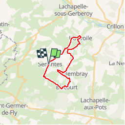
Tocht Stappen van 18,7 km beschikbaar op Hauts-de-France, Oise, Senantes. Deze tocht wordt voorgesteld door jpblimond.

Beschrijving

Entre le KM 6,9 et le Km 7,3 le terrain est impraticable

Hoogteprofiel

Foto's

Plaatsbepaling

Land:
France
Regio :
Hauts-de-France
Departement/Provincie :
Oise
Gemeente :
Senantes
Locatie:
Unknown
Vertrek:(UTM)
415715 ; 5482165 (31U) N.

Wandeltochten in de omgeving

Tocht Mountainbike Lachapelle-aux-Pots - ACTIVE LOG 003 - Photo
Mountainbike
sebcar

Mountainbike

Medium
(1)
Lachapelle-aux-Pots, Hauts-de-France, Oise, France
19,1 km | 24 km-effort
1h 39min
Ja
Tocht Stappen Hanvoile - 20200903-Gerberoy - Photo
Stappen
doudet

Stappen

Medium
Hanvoile, Hauts-de-France, Oise, France
24 km | 29 km-effort
6h 59min
Ja
Tocht Te voet Gerberoy - gerberoy - Photo
Te voet
nicole.reine@wanadoo.fr

Te voet

Gemakkelijk
Gerberoy, Hauts-de-France, Oise, France
6,3 km | 8 km-effort
1h 49min
Ja
Tocht Stappen Villers-sur-Auchy - Villers-sur-Auchy  - Photo
Stappen
jpblimond

Stappen

Medium
Villers-sur-Auchy, Hauts-de-France, Oise, France
18,1 km | 22 km-effort
4h 11min
Ja
Tocht Stappen Lachapelle-aux-Pots - Lachapelle-aux-pots - Héricourt - La Frénoye - Armentières - Photo
Stappen
Marie-Claire-mcp

Stappen

Moeilijk
Lachapelle-aux-Pots, Hauts-de-France, Oise, France
10,7 km | 13,7 km-effort
3h 6min
Ja
Tocht Stappen Lachapelle-aux-Pots - Lachapelle aux pots - Armentières 11 km - Photo
Stappen
Marie-Claire-mcp

Stappen

Moeilijk
Lachapelle-aux-Pots, Hauts-de-France, Oise, France
10,6 km | 13,5 km-effort
3h 4min
Ja
Tocht Stappen Lachapelle-aux-Pots - Lachapelle aux Pots - Rando santé 1 - Photo
Stappen
marcel.F

Stappen

Medium
Lachapelle-aux-Pots, Hauts-de-France, Oise, France
5,6 km | 6,4 km-effort
1h 24min
Ja
Tocht Stappen Lachapelle-aux-Pots - Lachapelle-aux-Pots - autour de la Crapaudière vers 2 - Photo
Stappen
marcel.F

Stappen

Gemakkelijk
Lachapelle-aux-Pots, Hauts-de-France, Oise, France
9,9 km | 11,5 km-effort
2h 32min
Ja
Tocht Stappen Lachapelle-aux-Pots - Lachapelle-aux-Pots - autour de la Crapaudière - Photo
Stappen
marcel.F

Stappen

Gemakkelijk
Lachapelle-aux-Pots, Hauts-de-France, Oise, France
9,4 km | 10,9 km-effort
2h 25min
Ja


Sluiten
Mijn abonnementen