Tour Wandern Senantes - Senantes - Photo
 jpblimond
jpblimond

Benutzer

© OpenStreetMap contributors
Länge
Länge
18,7 km
Maximale Höhe
Maximale Höhe
207 m
Positive Höhendifferenz
296 m
Km-Effort
Km-Effort  
23 km
Min. Höhe
Min. Höhe
111 m
Negative Höhendifferenz
294 m
Boucle
Boucle
Ja
Erstellungsdatum :
2019-04-22 11:05:30.472
Letzte Änderung :
2019-04-27 16:49:30.489

(0 Nachricht)

Wandern
Wandern
4h47
Schwierigkeit : Medium

Scannen Sie diesen QR-Code, um die Tour in der SityTrail-Anwendung zu öffnen

Kostenlosegpshiking-Anwendung

Logo SityTrail SityTrail

IGN / Geografische Institute

SityTrail aus dem App Store herunterladen SityTrail von Google Play herunterladen

Logo SityTrail SityTrail World

Die Welt öffnet sich für Sie

SityTrail aus dem App Store herunterladen SityTrail von Google Play herunterladen SityTrail auf Huawei AppGallery herunterladen

Über SityTrail

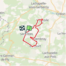
Tour Wandern von 18,7 km verfügbar auf Nordfrankreich, Oise, Senantes. Diese Tour wird von jpblimond vorgeschlagen.

Beschreibung

Entre le KM 6,9 et le Km 7,3 le terrain est impraticable

Höhenprofil

Foto-Galerie

Ort

Land:
France
Region :
Nordfrankreich
Abteilung/Provinz :
Oise
Kommune :
Senantes
Standort:
Unknown
Gehen Sie:(Dec)
Gehen Sie:(UTM)
415715 ; 5482165 (31U) N.

Touren in der Umgebung

Tour Mountainbike Lachapelle-aux-Pots - ACTIVE LOG 003 - Photo
Mountainbike
sebcar

Mountainbike

Medium
(1)
Lachapelle-aux-Pots, Nordfrankreich, Oise, France
19,1 km | 24 km-effort
1h 39min
Ja
Tour Wandern Hanvoile - 20200903-Gerberoy - Photo
Wandern
doudet

Wandern

Medium
Hanvoile, Nordfrankreich, Oise, France
24 km | 29 km-effort
6h 59min
Ja
Tour Zu Fuß Gerberoy - gerberoy - Photo
Zu Fuß
nicole.reine@wanadoo.fr

Zu Fuß

Einfach
Gerberoy, Nordfrankreich, Oise, France
6,3 km | 8 km-effort
1h 49min
Ja
Tour Wandern Villers-sur-Auchy - Villers-sur-Auchy  - Photo
Wandern
jpblimond

Wandern

Medium
Villers-sur-Auchy, Nordfrankreich, Oise, France
18,1 km | 22 km-effort
4h 11min
Ja
Tour Wandern Lachapelle-aux-Pots - Lachapelle-aux-pots - Héricourt - La Frénoye - Armentières - Photo
Wandern
Marie-Claire-mcp

Wandern

Schwierig
Lachapelle-aux-Pots, Nordfrankreich, Oise, France
10,7 km | 13,7 km-effort
3h 6min
Ja
Tour Wandern Lachapelle-aux-Pots - Lachapelle aux pots - Armentières 11 km - Photo
Wandern
Marie-Claire-mcp

Wandern

Schwierig
Lachapelle-aux-Pots, Nordfrankreich, Oise, France
10,6 km | 13,5 km-effort
3h 4min
Ja
Tour Wandern Lachapelle-aux-Pots - Lachapelle aux Pots - Rando santé 1 - Photo
Wandern
marcel.F

Wandern

Medium
Lachapelle-aux-Pots, Nordfrankreich, Oise, France
5,6 km | 6,4 km-effort
1h 24min
Ja
Tour Wandern Lachapelle-aux-Pots - Lachapelle-aux-Pots - autour de la Crapaudière vers 2 - Photo
Wandern
marcel.F

Wandern

Einfach
Lachapelle-aux-Pots, Nordfrankreich, Oise, France
9,9 km | 11,5 km-effort
2h 32min
Ja
Tour Wandern Lachapelle-aux-Pots - Lachapelle-aux-Pots - autour de la Crapaudière - Photo
Wandern
marcel.F

Wandern

Einfach
Lachapelle-aux-Pots, Nordfrankreich, Oise, France
9,4 km | 10,9 km-effort
2h 25min
Ja


Schließen
Meine Abonnements