Tocht Fiets Gisors - Chaumont en vexin - roche guyon - Photo

Chaumont en vexin - roche guyon

 medhy60
medhy60

Gebruiker

© OpenStreetMap contributors
Lengte
Lengte
72 km
Max. hoogte
Max. hoogte
178 m
Positief hoogteverschil
841 m
Km-Effort
Km-Effort  
83 km
Min. hoogte
Min. hoogte
20 m
Negatief hoogteverschil
841 m
Boucle
Boucle
Ja
Datum van aanmaak :
2014-12-10 00:00:00.0
Laatste wijziging :
2014-12-10 00:00:00.0

(0 Bericht)

Fiets
Fiets
4h46
Moeilijkheid : Medium

Scan deze QR-code om de tocht te openen in de SityTrail-applicatie

Gratisgps-wandelapplicatie

Logo SityTrail SityTrail

IGN / Geografische instituten

SityTrail uit de App Store downloaden SityTrail uit Google Play downloaden

Logo SityTrail SityTrail World

De wereld gaat voor u open

SityTrail uit de App Store downloaden SityTrail uit Google Play downloaden SityTrail op Huawei AppGallery downloaden

Over ons

Tocht Fiets van 72 km beschikbaar op Normandië, Eure, Gisors. Deze tocht wordt voorgesteld door medhy60.

Hoogteprofiel

POI's

Plaatsbepaling

Land:
France
Regio :
Normandië
Departement/Provincie :
Eure
Gemeente :
Gisors
Locatie:
Unknown
Vertrek:(Dec)
Vertrek:(UTM)
411088 ; 5459221 (31U) N.

Wandeltochten in de omgeving

Tocht Stappen Delincourt - Delincourt, Le Mesnil, Reilly, La vierge, Delincourt - Photo
Stappen
Marie-Claire-mcp

Stappen

Medium
(1)
Delincourt, Hauts-de-France, Oise, France
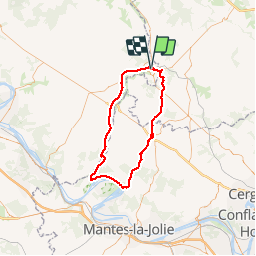
8,7 km | 10,4 km-effort
2h 16min
Ja
Tocht Stappen Boury-en-Vexin - Boury en Vexin - Hérouval - Photo
Stappen
marcel.F

Stappen

Gemakkelijk
(3)
Boury-en-Vexin, Hauts-de-France, Oise, France
10,9 km | 12,9 km-effort
2h 49min
Ja
Tocht Stappen Bézu-Saint-Éloi - Bézu Saint Eloi - Départ du parking route de Gisors (place St Eloi), puis Neaufles St martin - Photo
Stappen
Marie-Claire-mcp

Stappen

Medium
(1)
Bézu-Saint-Éloi, Normandië, Eure, France
10,3 km | 12 km-effort
2h 43min
Ja
Tocht Noords wandelen Boury-en-Vexin - Marche Nordique 75 Boury en Vexin - Photo
Noords wandelen
marcel.F

Noords wandelen

Gemakkelijk
(1)
Boury-en-Vexin, Hauts-de-France, Oise, France
10,3 km | 12,6 km-effort
1h 30min
Ja
Tocht Noords wandelen Courcelles-lès-Gisors - Marche Nordique 71 Courcelles les Gisors - Photo
Noords wandelen
marcel.F

Noords wandelen

Heel gemakkelijk
(2)
Courcelles-lès-Gisors, Hauts-de-France, Oise, France
9,2 km | 10,9 km-effort
1h 26min
Ja
Tocht Stappen Chambors - CHAMBORS - Lattainville-Delincourt-Reillly - Photo
Stappen
marcel.F

Stappen

Heel gemakkelijk
(1)
Chambors, Hauts-de-France, Oise, France
12,3 km | 15,2 km-effort
2h 54min
Ja
Tocht Noords wandelen Chambors - Marche Nordique 61 Chambors - Photo
Noords wandelen
marcel.F

Noords wandelen

Gemakkelijk
(1)
Chambors, Hauts-de-France, Oise, France
8,4 km | 10,3 km-effort
1h 30min
Ja
Tocht Stappen Trie-Château - Trie Château - La vallée de l'Aunette - Photo
Stappen
marcel.F

Stappen

Moeilijk
(1)
Trie-Château, Hauts-de-France, Oise, France
11,8 km | 13,7 km-effort
3h 0min
Ja
Tocht Stappen Chambors - Chambors - le dolmen 12 - Photo
Stappen
marcel.F

Stappen

Gemakkelijk
(1)
Chambors, Hauts-de-France, Oise, France
12,4 km | 16 km-effort
3h 31min
Ja


Sluiten
Mijn abonnementen