Tocht Stappen Lampaul-Guimiliau - petite st anne - Photo
 siboutchou
siboutchou

Gebruiker

© OpenStreetMap contributors
Lengte
Lengte
7,2 km
Max. hoogte
Max. hoogte
152 m
Positief hoogteverschil
98 m
Km-Effort
Km-Effort  
8,5 km
Min. hoogte
Min. hoogte
91 m
Negatief hoogteverschil
97 m
Boucle
Boucle
Ja
Datum van aanmaak :
2019-06-23 12:33:30.087
Laatste wijziging :
2019-06-23 14:12:53.355

(0 Bericht)

Stappen
Stappen
1h35
Moeilijkheid : Gemakkelijk

Scan deze QR-code om de tocht te openen in de SityTrail-applicatie

Gratisgps-wandelapplicatie

Logo SityTrail SityTrail

IGN / Geografische instituten

SityTrail uit de App Store downloaden SityTrail uit Google Play downloaden

Logo SityTrail SityTrail World

De wereld gaat voor u open

SityTrail uit de App Store downloaden SityTrail uit Google Play downloaden SityTrail op Huawei AppGallery downloaden

Over ons

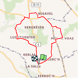
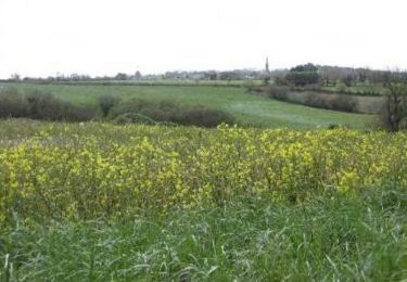
Tocht Stappen van 7,2 km beschikbaar op Bretagne, Finistère, Lampaul-Guimiliau. Deze tocht wordt voorgesteld door siboutchou.

Beschrijving

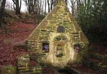
petit parcours de Sainte-Anne très bien pour les personnes qui veulent se remettre à la randonnée comme moi

Hoogteprofiel

Foto's

Plaatsbepaling

Land:
France
Regio :
Bretagne
Departement/Provincie :
Finistère
Gemeente :
Lampaul-Guimiliau
Locatie:
Unknown
Vertrek:(UTM)
423846 ; 5368148 (30U) N.

Wandeltochten in de omgeving

Tocht Stappen Guimiliau - Guimiliau et Lampaul-Guimiliau - Photo
Stappen
RonanDAGORN

Stappen

Zeer moeilijk
(1)
Guimiliau, Bretagne, Finistère, France
20 km | 24 km-effort
5h 23min
Ja
Tocht Te voet Lampaul-Guimiliau - Circuit de Sainte-Anasthasie - Photo
Te voet
PRO

Te voet

Gemakkelijk
Lampaul-Guimiliau, Bretagne, Finistère, France
9,7 km | 11,8 km-effort
2h 40min
Ja
Tocht Stappen Lampaul-Guimiliau - Les enclos du Léon - Photo
Stappen
neoroll44

Stappen

Medium
Lampaul-Guimiliau, Bretagne, Finistère, France
26 km | 31 km-effort
7h 0min
Ja
Tocht Stappen Loc-Eguiner - loc-eguiner - Photo
Stappen
miguelmillepattes

Stappen

Medium
Loc-Eguiner, Bretagne, Finistère, France
7,6 km | 9,4 km-effort
2h 1min
Ja
Tocht Noords wandelen Locmélar - locmelar - Photo
Noords wandelen
elianette

Noords wandelen

Heel gemakkelijk
Locmélar, Bretagne, Finistère, France
11,2 km | 13,9 km-effort
1h 13min
Ja
Tocht Te voet Saint-Sauveur - Circuit de Goas ar Scoul - Photo
Te voet
PRO

Te voet

Gemakkelijk
Saint-Sauveur, Bretagne, Finistère, France
8 km | 10 km-effort
2h 16min
Neen
Tocht Stappen Loc-Eguiner - Loc Eguiner et le circuit de la Vallée Perdue - Photo
Stappen
tracegps

Stappen

Medium
Loc-Eguiner, Bretagne, Finistère, France
13,2 km | 16,1 km-effort
3h 0min
Ja
Tocht Stappen Lampaul-Guimiliau - Autour de Lampaul - Guimiliau - Photo
Stappen
tracegps

Stappen

Medium
Lampaul-Guimiliau, Bretagne, Finistère, France
9,7 km | 11,8 km-effort
2h 0min
Ja
Tocht Stappen Guimiliau - 12237073-Circuit des deux rivières - Photo
Stappen
RonanDAGORN

Stappen

Medium
Guimiliau, Bretagne, Finistère, France
14,7 km | 17,5 km-effort
3h 58min
Ja


Sluiten
Mijn abonnementen