Tocht Stappen Sainte-Ode - mesa 3 Amberloup - Photo
 anjodena
anjodena

Gebruiker

© OpenStreetMap contributors
Lengte
Lengte
16,5 km
Max. hoogte
Max. hoogte
475 m
Positief hoogteverschil
336 m
Km-Effort
Km-Effort  
21 km
Min. hoogte
Min. hoogte
369 m
Negatief hoogteverschil
337 m
Boucle
Boucle
Ja
Datum van aanmaak :
2019-06-27 06:03:35.409
Laatste wijziging :
2019-06-27 10:40:38.46

(0 Bericht)

Stappen
Stappen
3h23
Moeilijkheid : Gemakkelijk

Scan deze QR-code om de tocht te openen in de SityTrail-applicatie

Gratisgps-wandelapplicatie

Logo SityTrail SityTrail

IGN / Geografische instituten

SityTrail uit de App Store downloaden SityTrail uit Google Play downloaden

Logo SityTrail SityTrail World

De wereld gaat voor u open

SityTrail uit de App Store downloaden SityTrail uit Google Play downloaden SityTrail op Huawei AppGallery downloaden

Over ons

Tocht Stappen van 16,5 km beschikbaar op Wallonië, Luxemburg, Sainte-Ode. Deze tocht wordt voorgesteld door anjodena.

Hoogteprofiel

Foto's

Plaatsbepaling

Land:
Belgium
Regio :
Wallonië
Departement/Provincie :
Luxemburg
Gemeente :
Sainte-Ode
Locatie:
Amberloup
Vertrek:(UTM)
681264 ; 5545401 (31U) N.

Wandeltochten in de omgeving

Tocht Stappen Sainte-Ode - RB-LUX-08 - Raccourci - De part et d’autre de l’Ourthe occidentale - Photo
Stappen
PRO

Stappen

Moeilijk
(2)
Sainte-Ode, Wallonië, Luxemburg, Belgium
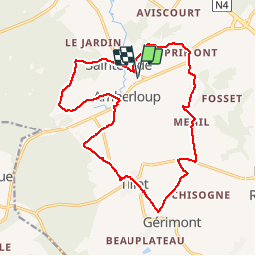
15,2 km | 18,6 km-effort
4h 13min
Ja
Tocht Stappen Sainte-Ode - Wandeling van Tonny - Photo
Stappen
GUIDE+

Stappen

Medium
(3)
Sainte-Ode, Wallonië, Luxemburg, Belgium
9,5 km | 12,2 km-effort
2h 36min
Ja
Tocht Stappen Sainte-Ode - Beauplateau - Wandeling
Stappen
GUIDE+

Stappen

Medium
(2)
Sainte-Ode, Wallonië, Luxemburg, Belgium
5,5 km | 6,9 km-effort
1h 29min
Ja
Tocht Stappen Sainte-Ode - Sainte-Ode - Wandeling van de Bonne Dame - Photo
Stappen
GUIDE+

Stappen

Medium
(4)
Sainte-Ode, Wallonië, Luxemburg, Belgium
7,7 km | 10 km-effort
2h 10min
Ja
Tocht Stappen Sainte-Ode - Amberloup, Natura 2000 - Des sites qui valent le détour. Lx11 - Photo
Stappen
GUIDE+

Stappen

Gemakkelijk
(4)
Sainte-Ode, Wallonië, Luxemburg, Belgium
4,2 km | 5 km-effort
1h 6min
Ja
Tocht Stappen Sainte-Ode - RB-LUX-08 - De part et d’autre de l’Ourthe occidentale - Photo
Stappen
PRO

Stappen

Medium
(1)
Sainte-Ode, Wallonië, Luxemburg, Belgium
23 km | 29 km-effort
6h 14min
Ja
Tocht Te voet Sainte-Ode - Sainte-ode - Photo
Te voet
gossim2

Te voet

Gemakkelijk
(3)
Sainte-Ode, Wallonië, Luxemburg, Belgium
8,9 km | 11,9 km-effort
Onbekend
Ja
Tocht Te voet Sainte-Ode - Dans Freyr par Bokaissart - Photo
Te voet
lancelot.be

Te voet

Medium
(1)
Sainte-Ode, Wallonië, Luxemburg, Belgium
4,6 km | 5,9 km-effort
1h 25min
Ja
Tocht Stappen Sainte-Ode - Beauplateau - Le sentier du Coprin (GTA 4) - Photo
Stappen
GUIDE+

Stappen

Zeer moeilijk
(2)
Sainte-Ode, Wallonië, Luxemburg, Belgium
16,6 km | 20 km-effort
4h 20min
Ja


Sluiten
Mijn abonnementen