


ardmore irl

FERREREMARC
Gebruiker
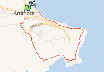

Lengte
4,1 km

Max. hoogte
57 m

Positief hoogteverschil
81 m
Km-Effort
5,2 km

Min. hoogte
0 m

Negatief hoogteverschil
88 m
Boucle
Neen
Datum van aanmaak :
2019-07-04 15:03:30.829
Laatste wijziging :
2019-07-04 16:27:44.111
1h23
Moeilijkheid : Heel gemakkelijk

Gratisgps-wandelapplicatie
 SityTrail
IGN / Geografische instituten
SityTrail World
De wereld gaat voor u open
Over ons
Tocht Stappen van 4,1 km beschikbaar op Onbekend, County Waterford, The Municipal District of Dungarvan — Lismore. Deze tocht wordt voorgesteld door FERREREMARC.
Plaatsbepaling
Land:
Ireland
Regio :
Onbekend
Departement/Provincie :
County Waterford
Gemeente :
The Municipal District of Dungarvan — Lismore
Locatie:
Ardmore
Vertrek:(Dec)
Vertrek:(UTM)
587588 ; 5756305 (29U) N.
Opmerkingen
Wandeltochten in de omgeving