Tocht Fietstoerisme Romorantin-Lanthenay - boucle Romorantin  - Photo
 levequejef
levequejef

Gebruiker

© OpenStreetMap contributors
Lengte
Lengte
28 km
Max. hoogte
Max. hoogte
133 m
Positief hoogteverschil
199 m
Km-Effort
Km-Effort  
31 km
Min. hoogte
Min. hoogte
88 m
Negatief hoogteverschil
198 m
Boucle
Boucle
Ja
Datum van aanmaak :
2019-07-08 07:44:30.885
Laatste wijziging :
2019-07-08 09:35:52.418

(0 Bericht)

Fietstoerisme
Fietstoerisme
1h50
Moeilijkheid : Heel gemakkelijk

Scan deze QR-code om de tocht te openen in de SityTrail-applicatie

Gratisgps-wandelapplicatie

Logo SityTrail SityTrail

IGN / Geografische instituten

SityTrail uit de App Store downloaden SityTrail uit Google Play downloaden

Logo SityTrail SityTrail World

De wereld gaat voor u open

SityTrail uit de App Store downloaden SityTrail uit Google Play downloaden SityTrail op Huawei AppGallery downloaden

Over ons

Tocht Fietstoerisme van 28 km beschikbaar op Centre-Val de Loire, Loir-et-Cher, Romorantin-Lanthenay. Deze tocht wordt voorgesteld door levequejef.

Hoogteprofiel

Plaatsbepaling

Land:
France
Regio :
Centre-Val de Loire
Departement/Provincie :
Loir-et-Cher
Gemeente :
Romorantin-Lanthenay
Locatie:
Unknown
Vertrek:(UTM)
403644 ; 5246821 (31T) N.

Wandeltochten in de omgeving

Tocht Lopen Romorantin-Lanthenay - boucle Romorantin  - Photo
Lopen
levequejef

Lopen

Heel gemakkelijk
Romorantin-Lanthenay, Centre-Val de Loire, Loir-et-Cher, France
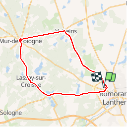
14,6 km | 15,9 km-effort
2h 6min
Ja
Tocht Noords wandelen Romorantin-Lanthenay - boucle Romorantin  - Photo
Noords wandelen
levequejef

Noords wandelen

Heel gemakkelijk
Romorantin-Lanthenay, Centre-Val de Loire, Loir-et-Cher, France
7,6 km | 8,3 km-effort
1h 37min
Ja
Tocht Stappen Pruniers-en-Sologne - lassay la chatre - Photo
Stappen
lecmic

Stappen

Gemakkelijk
Pruniers-en-Sologne, Centre-Val de Loire, Loir-et-Cher, France
11,4 km | 12,6 km-effort
2h 35min
Ja
Tocht Wegfiets Romorantin-Lanthenay - romo marcilly romo  - Photo
Wegfiets
mimilolo

Wegfiets

Heel gemakkelijk
Romorantin-Lanthenay, Centre-Val de Loire, Loir-et-Cher, France
40 km | 44 km-effort
1h 48min
Ja
Tocht Stappen Romorantin-Lanthenay - Romo Valençay  - Photo
Stappen
lecmic

Stappen

Medium
Romorantin-Lanthenay, Centre-Val de Loire, Loir-et-Cher, France
36 km | 40 km-effort
7h 26min
Neen
Tocht Stappen Romorantin-Lanthenay - romorantin - Photo
Stappen
lecmic

Stappen

Gemakkelijk
Romorantin-Lanthenay, Centre-Val de Loire, Loir-et-Cher, France
11 km | 12,1 km-effort
1h 46min
Ja
Tocht Noords wandelen Pruniers-en-Sologne - pruniers - Photo
Noords wandelen
lecmic

Noords wandelen

Heel gemakkelijk
Pruniers-en-Sologne, Centre-Val de Loire, Loir-et-Cher, France
12 km | 13,2 km-effort
2h 41min
Ja
Tocht Stappen Romorantin-Lanthenay - romorantin chabris - Photo
Stappen
lecmic

Stappen

Heel gemakkelijk
Romorantin-Lanthenay, Centre-Val de Loire, Loir-et-Cher, France
19 km | 20 km-effort
4h 9min
Neen
Tocht Lopen Romorantin-Lanthenay - romorantin - Photo
Lopen
levequejef

Lopen

Gemakkelijk
Romorantin-Lanthenay, Centre-Val de Loire, Loir-et-Cher, France
5,7 km | 6,2 km-effort
2h 0min
Neen


Sluiten
Mijn abonnementen