Tocht Mountainbike Caubeyres - Caubeyres-Villefranche du Queyran en VTT avec chien.  - Photo

Caubeyres-Villefranche du Queyran en VTT avec chien.

 Domie38
Domie38

Gebruiker

© OpenStreetMap contributors
Lengte
Lengte
17,4 km
Max. hoogte
Max. hoogte
142 m
Positief hoogteverschil
239 m
Km-Effort
Km-Effort  
21 km
Min. hoogte
Min. hoogte
62 m
Negatief hoogteverschil
239 m
Boucle
Boucle
Ja
Datum van aanmaak :
2019-07-15 08:21:20.0
Laatste wijziging :
2019-07-15 12:17:42.13

(0 Bericht)

Mountainbike
Mountainbike
3h06
Moeilijkheid : Gemakkelijk

Scan deze QR-code om de tocht te openen in de SityTrail-applicatie

Gratisgps-wandelapplicatie

Logo SityTrail SityTrail

IGN / Geografische instituten

SityTrail uit de App Store downloaden SityTrail uit Google Play downloaden

Logo SityTrail SityTrail World

De wereld gaat voor u open

SityTrail uit de App Store downloaden SityTrail uit Google Play downloaden SityTrail op Huawei AppGallery downloaden

Over ons

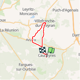
Tocht Mountainbike van 17,4 km beschikbaar op Nieuw-Aquitanië, Lot-et-Garonne, Caubeyres. Deze tocht wordt voorgesteld door Domie38.

Beschrijving

Route et chemin pour chercher ombre et points d’eau pour notre chien

Hoogteprofiel

Plaatsbepaling

Land:
France
Regio :
Nieuw-Aquitanië
Departement/Provincie :
Lot-et-Garonne
Gemeente :
Caubeyres
Locatie:
Unknown
Vertrek:(Dec)
Vertrek:(UTM)
276596 ; 4904000 (31T) N.

Wandeltochten in de omgeving

Tocht Te voet Xaintrailles - Xaintrailles, la balade du château - 4.7 km - Photo
Te voet
PRO

Te voet

Gemakkelijk
Xaintrailles, Nieuw-Aquitanië, Lot-et-Garonne, France
4,6 km | 5,9 km-effort
1h 19min
Ja
Tocht Te voet Fargues-sur-Ourbise - Fargues-sur-Ourbise, une île en forêt - 11.7 km - Photo
Te voet
PRO

Te voet

Gemakkelijk
Fargues-sur-Ourbise, Nieuw-Aquitanië, Lot-et-Garonne, France
9,9 km | 11,2 km-effort
2h 32min
Neen
Tocht Te voet Caubeyres - Caubeyres, la fontaine bouillonnante - 10.7 km - Photo
Te voet
PRO

Te voet

Gemakkelijk
Caubeyres, Nieuw-Aquitanië, Lot-et-Garonne, France
10,2 km | 12,8 km-effort
2h 54min
Ja
Tocht Te voet Damazan - Saint-Pierre-de-Buzet, la randonnée du Cap-du-Bosc - 12 km - Photo
Te voet
PRO

Te voet

Gemakkelijk
Damazan, Nieuw-Aquitanië, Lot-et-Garonne, France
14,1 km | 19 km-effort
4h 19min
Ja
Tocht Te voet Xaintrailles - Ambrus, la balade forestière de Pelane - 7.3 km - Photo
Te voet
PRO

Te voet

Gemakkelijk
Xaintrailles, Nieuw-Aquitanië, Lot-et-Garonne, France
7,1 km | 8,8 km-effort
1h 59min
Ja
Tocht Te voet Xaintrailles - Ambrus, promenade vers le vignoble de Padère - 9.5 km - Photo
Te voet
PRO

Te voet

Gemakkelijk
Xaintrailles, Nieuw-Aquitanië, Lot-et-Garonne, France
5,1 km | 6,1 km-effort
1h 23min
Neen
Tocht Te voet Xaintrailles - Ambrus, découverte de la forêt - 6.2 km - Photo
Te voet
PRO

Te voet

Gemakkelijk
Xaintrailles, Nieuw-Aquitanië, Lot-et-Garonne, France
6,2 km | 7,7 km-effort
1h 45min
Ja
Tocht Te voet Anzex - Anzex, la promenade de Pèleperdrix (7,9 km, balisage jaune) - Photo
Te voet
PRO

Te voet

Gemakkelijk
Anzex, Nieuw-Aquitanië, Lot-et-Garonne, France
7,6 km | 9,4 km-effort
2h 8min
Neen
Tocht Stappen Caubeyres - Antenne Caubeyres  - Photo
Stappen
Domie38

Stappen

Medium
Caubeyres, Nieuw-Aquitanië, Lot-et-Garonne, France
9,4 km | 11,6 km-effort
2h 24min
Ja


Sluiten
Mijn abonnementen