Tocht Geocaching Villy-lez-Falaise - Voie verte Falaise - Photo
 yannick-p
yannick-p

Gebruiker

© OpenStreetMap contributors
Lengte
Lengte
6,3 km
Max. hoogte
Max. hoogte
106 m
Positief hoogteverschil
44 m
Km-Effort
Km-Effort  
6,9 km
Min. hoogte
Min. hoogte
72 m
Negatief hoogteverschil
44 m
Boucle
Boucle
Ja
Datum van aanmaak :
29/07/2019 15:42
Laatste wijziging :
29/07/2019 15:45

(0 Bericht)

Geocaching
Geocaching
--
Moeilijkheid : Heel gemakkelijk

Scan deze QR-code om de tocht te openen in de SityTrail-applicatie

Gratisgps-wandelapplicatie

Logo SityTrail SityTrail

IGN / Geografische instituten

SityTrail uit de App Store downloaden SityTrail uit Google Play downloaden

Logo SityTrail SityTrail Plus

De wereld gaat voor u open

SityTrail uit de App Store downloaden SityTrail uit Google Play downloaden SityTrail op Huawei AppGallery downloaden

Over ons

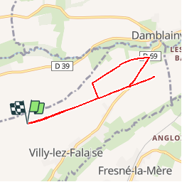
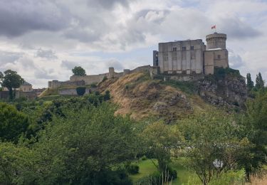
Tocht Geocaching van 6,3 km beschikbaar op Normandië, Calvados, Villy-lez-Falaise. Deze tocht wordt voorgesteld door yannick-p.

Hoogteprofiel

Plaatsbepaling

Land:
France
Regio :
Normandië
Departement/Provincie :
Calvados
Gemeente :
Villy-lez-Falaise
Locatie:
Unknown
Vertrek:(Dec)
Vertrek:(UTM)
709034 ; 5420390 (30U) N.


Sluiten
Mijn abonnementen