Tocht Andere activiteiten Orsières - Catogne - Photo
 tsg
tsg

Gebruiker

© OpenStreetMap contributors
Lengte
Lengte
10 km
Max. hoogte
Max. hoogte
2577 m
Positief hoogteverschil
1340 m
Km-Effort
Km-Effort  
28 km
Min. hoogte
Min. hoogte
1320 m
Negatief hoogteverschil
1345 m
Boucle
Boucle
Ja
Datum van aanmaak :
2014-12-11 00:00:00.0
Laatste wijziging :
2014-12-11 00:00:00.0

(0 Bericht)

Andere activiteiten
Andere activiteiten
--
Moeilijkheid : Onbekend

Scan deze QR-code om de tocht te openen in de SityTrail-applicatie

Gratisgps-wandelapplicatie

Logo SityTrail SityTrail

IGN / Geografische instituten

SityTrail uit de App Store downloaden SityTrail uit Google Play downloaden

Logo SityTrail SityTrail World

De wereld gaat voor u open

SityTrail uit de App Store downloaden SityTrail uit Google Play downloaden SityTrail op Huawei AppGallery downloaden

Over ons

Tocht Andere activiteiten van 10 km beschikbaar op Valais/Wallis, Entremont, Orsières. Deze tocht wordt voorgesteld door tsg.

Beschrijving

Follatères, Les Jeures Brûlées, Six Carro, Portail de Fully, Les Garettes, Eulo

Hoogteprofiel

Plaatsbepaling

Land:
Switzerland
Regio :
Valais/Wallis
Departement/Provincie :
Entremont
Gemeente :
Orsières
Locatie:
Unknown
Vertrek:(Dec)
Vertrek:(UTM)
352085 ; 5101294 (32T) N.

Wandeltochten in de omgeving

Tocht Te voet Orsières - sentier du Devin - Photo
Te voet
PRO

Te voet

Gemakkelijk
Orsières, Valais/Wallis, Entremont, Switzerland
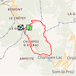
3,9 km | 6,7 km-effort
1h 31min
Ja
Tocht Te voet Bovernier - Chemins pédestre de montagne, région Entremont - Photo
Te voet
PRO

Te voet

Medium
Bovernier, Valais/Wallis, Martigny, Switzerland
6,9 km | 22 km-effort
4h 54min
Neen
Tocht Te voet Orsières - Raccard du blé - Photo
Te voet
PRO

Te voet

Gemakkelijk
Orsières, Valais/Wallis, Entremont, Switzerland
7,9 km | 13,7 km-effort
3h 6min
Ja
Tocht Stappen Orsières - TMB 08 - Relais d'Arpette -> Trient - Photo
Stappen
uru2010

Stappen

Moeilijk
Orsières, Valais/Wallis, Entremont, Switzerland
17 km | 28 km-effort
6h 39min
Neen
Tocht Sneeuwschoenen Orsières - Champex Lac - La Breya - Champex Lac - Photo
Sneeuwschoenen
jpksenicz

Sneeuwschoenen

Medium
Orsières, Valais/Wallis, Entremont, Switzerland
8,8 km | 18,2 km-effort
3h 1min
Ja
Tocht Stappen Orsières - CMX ZRMT Étape 2 Champex Cabane de Mille  - Photo
Stappen
jeff2

Stappen

Medium
Orsières, Valais/Wallis, Entremont, Switzerland
17,9 km | 38 km-effort
7h 15min
Neen
Tocht Stappen Orsières - TMB day 5 - Photo
Stappen
elixpomatia

Stappen

Medium
Orsières, Valais/Wallis, Entremont, Switzerland
16,7 km | 28 km-effort
6h 15min
Neen
Tocht Te voet Val de Bagnes - LaboNature Entremont - Photo
Te voet
PRO

Te voet

Gemakkelijk
Val de Bagnes, Valais/Wallis, Entremont, Switzerland
3,5 km | 5,1 km-effort
1h 8min
Ja
Tocht Te voet Sembrancher - Chemins pédestre de montagne, commune de Sembrancher - Photo
Te voet
PRO

Te voet

Gemakkelijk
Sembrancher, Valais/Wallis, Entremont, Switzerland
3 km | 10,4 km-effort
2h 21min
Neen


Sluiten
Mijn abonnementen