Tocht Stappen Conthey - Mayens de Conthey - Croix de la châ - Photo

Mayens de Conthey - Croix de la châ

 duamerg
duamerg

Gebruiker

© OpenStreetMap contributors
Lengte
Lengte
15,1 km
Max. hoogte
Max. hoogte
2350 m
Positief hoogteverschil
941 m
Km-Effort
Km-Effort  
28 km
Min. hoogte
Min. hoogte
1477 m
Negatief hoogteverschil
948 m
Boucle
Boucle
Ja
Datum van aanmaak :
2014-12-11 00:00:00.0
Laatste wijziging :
2020-01-30 13:58:25.359

(0 Bericht)

Stappen
Stappen
5h46
Moeilijkheid : Gemakkelijk

Scan deze QR-code om de tocht te openen in de SityTrail-applicatie

Gratisgps-wandelapplicatie

Logo SityTrail SityTrail

IGN / Geografische instituten

SityTrail uit de App Store downloaden SityTrail uit Google Play downloaden

Logo SityTrail SityTrail World

De wereld gaat voor u open

SityTrail uit de App Store downloaden SityTrail uit Google Play downloaden SityTrail op Huawei AppGallery downloaden

Over ons

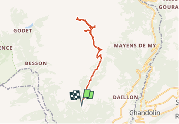
Tocht Stappen van 15,1 km beschikbaar op Valais/Wallis, Conthey, Conthey. Deze tocht wordt voorgesteld door duamerg.

Beschrijving

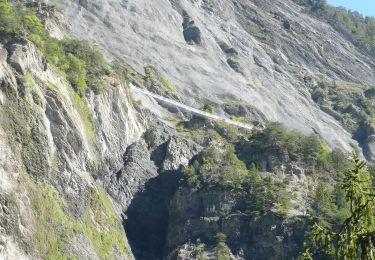
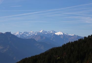
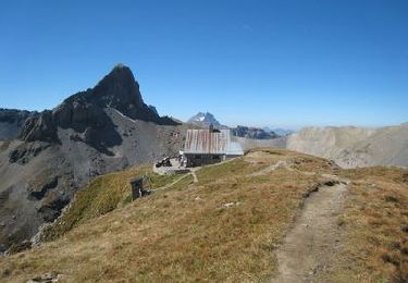
Prendre la route du col du Sanetsch jusqu'à Daillon. Monter aux Mayens de Conthey jusqu'à Codo et le départ de nombreuses courses. Laisser la voiture. Chemin bien balisé et facile par l'étang de trente pas jusqu'au col de la Croix de la Châ. Retour par le même chemin.

Hoogteprofiel

Plaatsbepaling

Land:
Switzerland
Regio :
Valais/Wallis
Departement/Provincie :
Conthey
Gemeente :
Conthey
Locatie:
Unknown
Vertrek:(Dec)
Vertrek:(UTM)
367045 ; 5123507 (32T) N.

Wandeltochten in de omgeving

Tocht Te voet Savièse - Bisse de Savièse (Torrent-Neuf) - Photo
Te voet
PRO

Te voet

Gemakkelijk
Savièse, Valais/Wallis, Sion, Switzerland
4,5 km | 7,4 km-effort
1h 41min
Neen
Tocht Te voet Ardon - Chemin des berges du Rhône - Photo
Te voet
PRO

Te voet

Gemakkelijk
Ardon, Valais/Wallis, Conthey, Switzerland
4,4 km | 4,9 km-effort
1h 6min
Neen
Tocht Te voet Conthey - Bisse de la Tsandra - Photo
Te voet
PRO

Te voet

Gemakkelijk
Conthey, Valais/Wallis, Conthey, Switzerland
7,4 km | 10,5 km-effort
2h 23min
Neen
Tocht Stappen Sion - Tour du Massif des Muverans - Photo
Stappen
illustre

Stappen

Heel gemakkelijk
Sion, Valais/Wallis, Sion, Switzerland
6,2 km | 14,1 km-effort
22h 11min
Neen
Tocht Andere activiteiten Conthey - st_bg_conthey - Photo
Andere activiteiten
GUIDE+

Andere activiteiten

Heel gemakkelijk
Conthey, Valais/Wallis, Conthey, Switzerland
22 km | 42 km-effort
9h 21min
Neen
Tocht Stappen Conthey - huetten_02 - Photo
Stappen
GUIDE+

Stappen

Heel gemakkelijk
Conthey, Valais/Wallis, Conthey, Switzerland
50 km | 102 km-effort
16h 52min
Ja
Tocht Stappen Conthey - Trajet du 29.10.21 - Photo
Stappen
Leemans

Stappen

Zeer moeilijk
Conthey, Valais/Wallis, Conthey, Switzerland
19,5 km | 38 km-effort
8h 42min
Ja
Tocht Noords wandelen Savièse - bisse torrent neuf - Photo
Noords wandelen
ericf64

Noords wandelen

Gemakkelijk
Savièse, Valais/Wallis, Sion, Switzerland
9,1 km | 14,2 km-effort
3h 20min
Ja
Tocht Stappen Conthey - Lac Forcla - Photo
Stappen
jipi2

Stappen

Medium
Conthey, Valais/Wallis, Conthey, Switzerland
16,8 km | 33 km-effort
8h 1min
Ja


Sluiten
Mijn abonnementen