![](/images/other/stat-length.png)
![Tocht Stappen Sauve - Sauve - Mer des rochers - Photo](https://media.geolcdn.com/t/1900/400/ext.pjpeg?maxdim=2&url=https%3A%2F%2Fmedia.geolcdn.com%2Ff%2Fdc5d0495-41b1-4045-907b-e46f9c00f109.jpg)
Sauve - Mer des rochers
campingmasdelacam
Gebruiker
![Lengte](/images/other/stat-length.png)
Lengte
4,9 km
![Max. hoogte](https://static1.geolcdn.com/siteimages/upload/files/1508320355ic_sort_altitude_max_24dp.png)
Max. hoogte
154 m
![Positief hoogteverschil](https://static1.geolcdn.com/siteimages/upload/files/1508320355ic_sort_den_pos_24dp.png)
Positief hoogteverschil
88 m
![Km-Effort](/images/other/stat-length.png)
Km-Effort
6 km
![Min. hoogte](https://static1.geolcdn.com/siteimages/upload/files/1508320355ic_sort_altitude_min_24dp.png)
Min. hoogte
96 m
![Negatief hoogteverschil](https://static1.geolcdn.com/siteimages/upload/files/1508320355ic_sort_den_neg_24dp.png)
Negatief hoogteverschil
88 m
![Boucle](https://static1.geolcdn.com/siteimages/upload/files/16400158638029165_repeat_loop_refresh_sync_direction_icon.png)
Boucle
Ja
Datum van aanmaak :
2019-12-28 12:35:12.0
Laatste wijziging :
2019-12-29 09:41:30.419
![Stappen](https://static1.geolcdn.com/sitytour/trail-icons/101.png)
1h30
Moeilijkheid : Onbekend
![Scan deze QR-code om de tocht te openen in de SityTrail-applicatie](https://capi.geolives.com/qq0zvz2zws4bq2lad0pu/sitytour/trails/2291788/qr.png?size=200)
Gratisgps-wandelapplicatie
Over ons
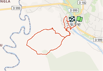
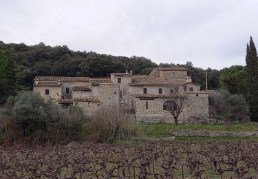
Tocht Stappen van 4,9 km beschikbaar op Occitanië, Gard, Sauve. Deze tocht wordt voorgesteld door campingmasdelacam.
Beschrijving
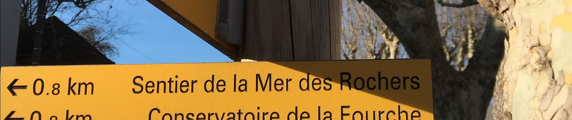
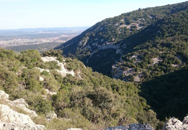
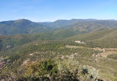
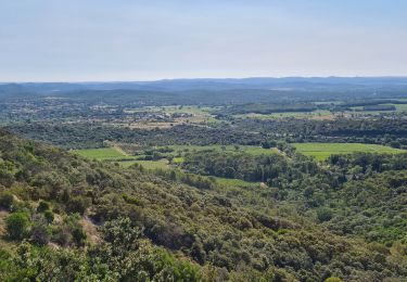
Peu de dénivelé, dans les bois de chênes, belle vue sur la mer des rochers, le tour de Sauve en fin de parcours est intéresssant !
Plaatsbepaling
Land:
France
Regio :
Occitanië
Departement/Provincie :
Gard
Gemeente :
Sauve
Locatie:
Unknown
Vertrek:(Dec)
Vertrek:(UTM)
576392 ; 4865690 (31T) N.
Opmerkingen
Wandeltochten in de omgeving
![Tocht Stappen Quissac - Quissac - Photo](https://media.geolcdn.com/t/375/260/ext.jpg?maxdim=2&url=https%3A%2F%2Fservices.sitytrail.com%2FGeolivesWS%2FDownloadMedia.ashx%3FTrailID%3D233243%26Media%3Dfix__20131117121007.jpg)
![Stappen Stappen](https://static1.geolcdn.com/sitytour/trail-icons/101.png)
![Tocht Te voet Liouc - Les chênes de Coutach - Photo](https://media.geolcdn.com/t/375/260/ext.jpg?maxdim=2&url=https%3A%2F%2Fmedia.geolcdn.com%2Ff%2Fcf45b531-3715-4133-ba5a-b053d48b9be2.jpeg)
![Te voet Te voet](https://static1.geolcdn.com/sitytour/trail-icons/100.png)
Les chênes de Coutach
Te voet
Gemakkelijk
Liouc,
Occitanië,
Gard,
France
![](/images/other/stat-length.png)
6,7 km | 10,6 km-effort
2h 24min
![](https://static1.geolcdn.com/siteimages/upload/files/16400158638029165_repeat_loop_refresh_sync_direction_icon.png)
Neen
![Tocht Stappen Sauve - Chateau de Freissac / le Crespou - Photo](https://media.geolcdn.com/t/375/260/ext.jpg?maxdim=2&url=https%3A%2F%2Fmedia.geolcdn.com%2Ff%2F7c638cf8-dd40-4fbf-83bf-0016c1c94c8e.jpg)
![Stappen Stappen](https://static1.geolcdn.com/sitytour/trail-icons/101.png)
Chateau de Freissac / le Crespou
Stappen
Medium
Sauve,
Occitanië,
Gard,
France
![](/images/other/stat-length.png)
16,8 km | 23 km-effort
5h 40min
![](https://static1.geolcdn.com/siteimages/upload/files/16400158638029165_repeat_loop_refresh_sync_direction_icon.png)
Ja
![Tocht Stappen Sauve - Sauve, le sentier de l'Aven - Photo](https://media.geolcdn.com/t/375/260/ext.jpg?maxdim=2&url=https%3A%2F%2Fstatic1.geolcdn.com%2Fsiteimages%2Fupload%2Ffiles%2F1553511878bg_sport_marche.png)
![Stappen Stappen](https://static1.geolcdn.com/sitytour/trail-icons/101.png)
Sauve, le sentier de l'Aven
Stappen
Gemakkelijk
(1)
Sauve,
Occitanië,
Gard,
France
![](/images/other/stat-length.png)
4,2 km | 5,4 km-effort
1h 30min
![](https://static1.geolcdn.com/siteimages/upload/files/16400158638029165_repeat_loop_refresh_sync_direction_icon.png)
Ja
![Tocht Elektrische fiets Quissac - 52 Km avec 429 de dénivelé - Photo](https://media.geolcdn.com/t/375/260/ext.jpg?maxdim=2&url=https%3A%2F%2Fstatic1.geolcdn.com%2Fsiteimages%2Fupload%2Ffiles%2F1524743154velo.jpg)
![Elektrische fiets Elektrische fiets](https://static1.geolcdn.com/sitytour/trail-icons/205.png)
52 Km avec 429 de dénivelé
Elektrische fiets
Gemakkelijk
(1)
Quissac,
Occitanië,
Gard,
France
![](/images/other/stat-length.png)
52 km | 62 km-effort
2h 30min
![](https://static1.geolcdn.com/siteimages/upload/files/16400158638029165_repeat_loop_refresh_sync_direction_icon.png)
Ja
![Tocht Stappen Quissac - quissac domaine de la rouviere - Photo](https://media.geolcdn.com/t/375/260/ext.jpg?maxdim=2&url=https%3A%2F%2Fmedia.geolcdn.com%2Ff%2F8e50166c-0651-4f06-bfd7-2016f8a1c055.jpg)
![Stappen Stappen](https://static1.geolcdn.com/sitytour/trail-icons/101.png)
quissac domaine de la rouviere
Stappen
Gemakkelijk
Quissac,
Occitanië,
Gard,
France
![](/images/other/stat-length.png)
19,2 km | 23 km-effort
5h 6min
![](https://static1.geolcdn.com/siteimages/upload/files/16400158638029165_repeat_loop_refresh_sync_direction_icon.png)
Ja
![Tocht Stappen Conqueyrac - les 2 jumelles près de St hippolythe - Photo](https://media.geolcdn.com/t/375/260/ext.jpg?maxdim=2&url=https%3A%2F%2Fmedia.geolcdn.com%2Ff%2F9cbcc03d-0a76-4d68-85e5-d108525f8703.jpg)
![Stappen Stappen](https://static1.geolcdn.com/sitytour/trail-icons/101.png)
les 2 jumelles près de St hippolythe
Stappen
Medium
Conqueyrac,
Occitanië,
Gard,
France
![](/images/other/stat-length.png)
17,5 km | 25 km-effort
6h 3min
![](https://static1.geolcdn.com/siteimages/upload/files/16400158638029165_repeat_loop_refresh_sync_direction_icon.png)
Ja
![Tocht Stappen Sauve - Sauve-Quissac-Vidourle - Photo](https://media.geolcdn.com/t/375/260/ext.jpg?maxdim=2&url=https%3A%2F%2Fmedia.geolcdn.com%2Ff%2Ffd1a92a4-90ce-453a-8525-cca28d36a7d3.jpg)
![Stappen Stappen](https://static1.geolcdn.com/sitytour/trail-icons/101.png)
Sauve-Quissac-Vidourle
Stappen
Moeilijk
Sauve,
Occitanië,
Gard,
France
![](/images/other/stat-length.png)
22 km | 30 km-effort
6h 49min
![](https://static1.geolcdn.com/siteimages/upload/files/16400158638029165_repeat_loop_refresh_sync_direction_icon.png)
Ja
![Tocht Trail Sauve - Sauve - Photo](https://media.geolcdn.com/t/375/260/ext.jpg?maxdim=2&url=https%3A%2F%2Fstatic1.geolcdn.com%2Fsiteimages%2Fupload%2Ffiles%2F1524743154running.jpg)
![Trail Trail](https://static1.geolcdn.com/sitytour/trail-icons/104.png)