Tocht Ski randonnée Ollon - Villars - Photo
 Christophe.clt
Christophe.clt

Gebruiker

© OpenStreetMap contributors
Lengte
Lengte
5,3 km
Max. hoogte
Max. hoogte
1955 m
Positief hoogteverschil
668 m
Km-Effort
Km-Effort  
12 km
Min. hoogte
Min. hoogte
1280 m
Negatief hoogteverschil
1 m
Boucle
Boucle
Neen
Datum van aanmaak :
2020-02-18 18:14:38.635
Laatste wijziging :
2020-02-18 20:05:37.71

(0 Bericht)

Ski randonnée
Ski randonnée
1h50
Moeilijkheid : Medium

Scan deze QR-code om de tocht te openen in de SityTrail-applicatie

Gratisgps-wandelapplicatie

Logo SityTrail SityTrail

IGN / Geografische instituten

SityTrail uit de App Store downloaden SityTrail uit Google Play downloaden

Logo SityTrail SityTrail World

De wereld gaat voor u open

SityTrail uit de App Store downloaden SityTrail uit Google Play downloaden SityTrail op Huawei AppGallery downloaden

Over ons

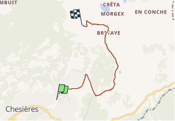
Tocht Ski randonnée van 5,3 km beschikbaar op Waadland, District d'Aigle, Ollon. Deze tocht wordt voorgesteld door Christophe.clt.

Hoogteprofiel

Plaatsbepaling

Land:
Switzerland
Regio :
Waadland
Departement/Provincie :
District d'Aigle
Gemeente :
Ollon
Locatie:
Unknown
Vertrek:(Dec)
Vertrek:(UTM)
350227 ; 5129615 (32T) N.

Wandeltochten in de omgeving

Tocht Te voet Ollon - Sentier du Sel - Photo
Te voet
PRO

Te voet

Gemakkelijk
Ollon, Waadland, District d'Aigle, Switzerland
4,5 km | 8 km-effort
1h 49min
Neen
Tocht Stappen Ollon - Le grand Chamossaire - Photo
Stappen
perenhout

Stappen

Medium
Ollon, Waadland, District d'Aigle, Switzerland
6,6 km | 15,6 km-effort
3h 48min
Neen
Tocht Andere activiteiten Leysin - bdr00_Leysin_StGingolphe - Photo
Andere activiteiten
GUIDE+

Andere activiteiten

Heel gemakkelijk
Leysin, Waadland, District d'Aigle, Switzerland
26 km | 32 km-effort
Onbekend
Neen
Tocht Andere activiteiten Leysin - xxx00_Leysin_StGingolphe - Photo
Andere activiteiten
GUIDE+

Andere activiteiten

Heel gemakkelijk
Leysin, Waadland, District d'Aigle, Switzerland
26 km | 32 km-effort
6h 41min
Neen
Tocht Stappen Ollon - st_bg_villars1 - Photo
Stappen
GUIDE+

Stappen

Heel gemakkelijk
Ollon, Waadland, District d'Aigle, Switzerland
5,6 km | 8,3 km-effort
Onbekend
Neen
Tocht Mountainbike Leysin - Bike32915 - Photo
Mountainbike
GUIDE+

Mountainbike

Heel gemakkelijk
Leysin, Waadland, District d'Aigle, Switzerland
30 km | 49 km-effort
Onbekend
Ja
Tocht Mountainbike Ollon - Bike32918 - Photo
Mountainbike
GUIDE+

Mountainbike

Heel gemakkelijk
Ollon, Waadland, District d'Aigle, Switzerland
22 km | 35 km-effort
Onbekend
Ja
Tocht Stappen Leysin - solacyre - Photo
Stappen
rufi

Stappen

Gemakkelijk
Leysin, Waadland, District d'Aigle, Switzerland
2,7 km | 6,3 km-effort
1h 20min
Neen
Tocht Lopen Gryon - Mxalps - Photo
Lopen
gut72ch

Lopen

Moeilijk
Gryon, Waadland, District d'Aigle, Switzerland
61 km | 116 km-effort
10h 0min
Neen


Sluiten
Mijn abonnementen