Tocht Stappen Breux-Jouy - Breux 20-02-2020 - Photo
 Joseph91
Joseph91

Gebruiker

© OpenStreetMap contributors
Lengte
Lengte
12,7 km
Max. hoogte
Max. hoogte
154 m
Positief hoogteverschil
193 m
Km-Effort
Km-Effort  
15,3 km
Min. hoogte
Min. hoogte
58 m
Negatief hoogteverschil
193 m
Boucle
Boucle
Ja
Datum van aanmaak :
2020-02-19 07:43:41.307
Laatste wijziging :
2020-02-20 08:30:56.41

(0 Bericht)

Stappen
Stappen
3h25
Moeilijkheid : Heel gemakkelijk

Scan deze QR-code om de tocht te openen in de SityTrail-applicatie

Gratisgps-wandelapplicatie

Logo SityTrail SityTrail

IGN / Geografische instituten

SityTrail uit de App Store downloaden SityTrail uit Google Play downloaden

Logo SityTrail SityTrail World

De wereld gaat voor u open

SityTrail uit de App Store downloaden SityTrail uit Google Play downloaden SityTrail op Huawei AppGallery downloaden

Over ons

Tocht Stappen van 12,7 km beschikbaar op Île-de-France, Essonne, Breux-Jouy. Deze tocht wordt voorgesteld door Joseph91.

Hoogteprofiel

Plaatsbepaling

Land:
France
Regio :
Île-de-France
Departement/Provincie :
Essonne
Gemeente :
Breux-Jouy
Locatie:
Unknown
Vertrek:(UTM)
437701 ; 5378829 (31U) N.

Wandeltochten in de omgeving

Tocht Stappen Saint-Sulpice-de-Favières - Les Pétales de Souzy - Photo
Stappen
tracegps

Stappen

Moeilijk
(1)
Saint-Sulpice-de-Favières, Île-de-France, Essonne, France
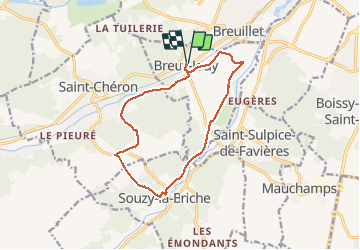
23 km | 29 km-effort
4h 49min
Ja
Tocht Te voet Saint-Yon - Sur les traces de la Renarde - Photo
Te voet
PRO

Te voet

Zeer moeilijk
Saint-Yon, Île-de-France, Essonne, France
38 km | 44 km-effort
10h 4min
Neen
Tocht Stappen Saint-Sulpice-de-Favières - St Sulpice - Photo
Stappen
Auger91

Stappen

Medium
(1)
Saint-Sulpice-de-Favières, Île-de-France, Essonne, France
8 km | 10,1 km-effort
2h 18min
Ja
Tocht Stappen Boissy-sous-Saint-Yon - Carrière de Madagascar  - Photo
Stappen
danbott

Stappen

Heel gemakkelijk
(1)
Boissy-sous-Saint-Yon, Île-de-France, Essonne, France
13,2 km | 16,5 km-effort
2h 59min
Ja
Tocht Stappen Saint-Chéron - De Saint Chéron à Dourdan par les côteaux de la rive gauche - Photo
Stappen
philippebenne

Stappen

Moeilijk
(1)
Saint-Chéron, Île-de-France, Essonne, France
13,5 km | 17 km-effort
3h 51min
Neen
Tocht Stappen Villeconin - Villeconin - Photo
Stappen
guydu41

Stappen

Medium
Villeconin, Île-de-France, Essonne, France
8,5 km | 10,9 km-effort
2h 11min
Ja
Tocht Stappen Saint-Sulpice-de-Favières - Saint-Sulpice-de-Favières - Photo
Stappen
guydu41

Stappen

Medium
Saint-Sulpice-de-Favières, Île-de-France, Essonne, France
7,5 km | 9,4 km-effort
1h 55min
Ja
Tocht Stappen Souzy-la-Briche - Carrières de Madagascar à Souzy-la-Briche  - Photo
Stappen
guydu41

Stappen

Medium
Souzy-la-Briche, Île-de-France, Essonne, France
6,8 km | 8,3 km-effort
1h 52min
Ja
Tocht Stappen Saint-Maurice-Montcouronne - Boucle St Maurice Montcouronne - Brigitte - Photo
Stappen
chessyca

Stappen

Heel gemakkelijk
Saint-Maurice-Montcouronne, Île-de-France, Essonne, France
21 km | 24 km-effort
4h 19min
Ja


Sluiten
Mijn abonnementen