Tocht Paardrijden Meyrueis - Boucle complète 141 km (avec modif amatuzzi 2020) - Photo

Boucle complète 141 km (avec modif amatuzzi 2020)

 Lozère Cheval
Lozère Cheval

Gebruiker

© OpenStreetMap contributors
Lengte
Lengte
141 km
Max. hoogte
Max. hoogte
1561 m
Positief hoogteverschil
3885 m
Km-Effort
Km-Effort  
193 km
Min. hoogte
Min. hoogte
503 m
Negatief hoogteverschil
3885 m
Boucle
Boucle
Ja
Datum van aanmaak :
2020-03-10 12:54:26.933
Laatste wijziging :
2021-11-18 11:59:51.076

(0 Bericht)

Paardrijden
Paardrijden
--
Moeilijkheid : Heel gemakkelijk

Scan deze QR-code om de tocht te openen in de SityTrail-applicatie

Gratisgps-wandelapplicatie

Logo SityTrail SityTrail

IGN / Geografische instituten

SityTrail uit de App Store downloaden SityTrail uit Google Play downloaden

Logo SityTrail SityTrail World

De wereld gaat voor u open

SityTrail uit de App Store downloaden SityTrail uit Google Play downloaden SityTrail op Huawei AppGallery downloaden

Over ons

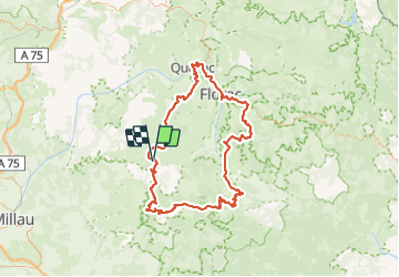
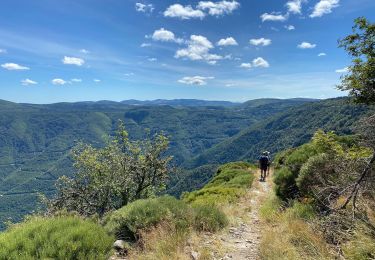
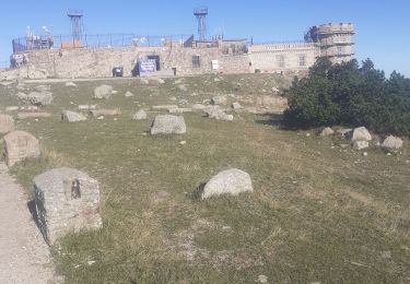
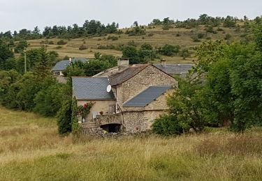
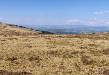
Tocht Paardrijden van 141 km beschikbaar op Occitanië, Lozère, Meyrueis. Deze tocht wordt voorgesteld door Lozère Cheval.

Hoogteprofiel

POI's

POI Florac Trois Rivières - Camping Val Cévennes - Photo
Lozère Cheval
FLORAC TROIS RIVIÈRES 
POI Barre-des-Cévennes - Croisette Combes - Photo
Lozère Cheval
BARRE-DES-CÉVENNES 
POI Lanuéjols - Aiguebonne - Photo
Lozère Cheval
LANUÉJOLS 
POI Meyrueis - Ecurie Méjean - Photo
Lozère Cheval
MEYRUEIS 
POI Hures-la-Parade - Auberge Chanet  - Photo
Lozère Cheval
HURES-LA-PARADE 
POI Ispagnac - Anes du  Vigos  - Photo
Lozère Cheval
ISPAGNAC 
POI Ispagnac - Amatuzzi - Photo
Lozère Cheval
ISPAGNAC 
POI Ispagnac - Hotel le Vallon  - Photo
Lozère Cheval
POI Ispagnac - Camping Cerisier - Photo
Lozère Cheval
POI Dourbies - Hotel du Parc l'Esperou - Photo
Lozère Cheval
POI Molezon - La Roquette G'Rando d'Anes - Photo
Lozère Cheval
POI Bassurels - Château du Poujol - Photo
Lozère Cheval

Plaatsbepaling

Land:
France
Regio :
Occitanië
Departement/Provincie :
Lozère
Gemeente :
Meyrueis
Locatie:
Unknown
Vertrek:(UTM)
534318 ; 4894624 (31T) N.

Wandeltochten in de omgeving

Tocht Wegfiets Meyrueis - tour aigoual - Photo
Wegfiets
rafde210

Wegfiets

Medium
(1)
Meyrueis, Occitanië, Lozère, France
58 km | 74 km-effort
3h 5min
Neen
Tocht Stappen Meyrueis - Meyrues à observatoire Mont Aigoual  - Photo
Stappen
GUIDE
nadinebondoux

Stappen

Moeilijk
Meyrueis, Occitanië, Lozère, France
21 km | 0 m-effort
5h 58min
Neen
Tocht Te voet Meyrueis - Sentier du Château de Roquedols - Photo
Te voet
PRO

Te voet

Gemakkelijk
Meyrueis, Occitanië, Lozère, France
5 km | 6,9 km-effort
1h 33min
Ja
Tocht Stappen Meyrueis - Meyruis L’Esperou 26 km - Tour du mont Aigual  étape 3 - Photo
Stappen
GUIDE
rvapeldo

Stappen

Moeilijk
Meyrueis, Occitanië, Lozère, France
28 km | 41 km-effort
9h 0min
Neen
Tocht Mountainbike Meyrueis - cause noir mai 2020 - Photo
Mountainbike
richard.roure

Mountainbike

Gemakkelijk
(1)
Meyrueis, Occitanië, Lozère, France
36 km | 44 km-effort
4h 37min
Ja
Tocht Stappen Meyrueis - Cabrillac - Photo
Stappen
ilur56

Stappen

Medium
(1)
Meyrueis, Occitanië, Lozère, France
24 km | 33 km-effort
7h 9min
Ja
Tocht Stappen Meyrueis - meyrues l'esperouvia le mont aigoual - Photo
Stappen
RoMo

Stappen

Moeilijk
Meyrueis, Occitanië, Lozère, France
31 km | 46 km-effort
8h 54min
Neen
Tocht Stappen Meyrueis - Meyruies - Gorges de la Jonte - Grotte de Dagilan - Photo
Stappen
Bart2015

Stappen

Medium
Meyrueis, Occitanië, Lozère, France
15,2 km | 21 km-effort
4h 25min
Ja
Tocht Stappen Meyrueis - Tour du Causse Méjean - Etape5 - Photo
Stappen
nolsim

Stappen

Moeilijk
Meyrueis, Occitanië, Lozère, France
27 km | 40 km-effort
8h 51min
Neen


Sluiten
Mijn abonnementen