Tocht Stappen Saint-Guilhem-le-Désert - Maison forestiere des plos - Photo
 jdelettrez
jdelettrez

Gebruiker

© OpenStreetMap contributors
Lengte
Lengte
11,7 km
Max. hoogte
Max. hoogte
526 m
Positief hoogteverschil
593 m
Km-Effort
Km-Effort  
19,6 km
Min. hoogte
Min. hoogte
66 m
Negatief hoogteverschil
589 m
Boucle
Boucle
Ja
Datum van aanmaak :
2014-12-10 00:00:00.0
Laatste wijziging :
2014-12-10 00:00:00.0

(1 Bericht)

Stappen
Stappen
4h08
Moeilijkheid : Medium

Scan deze QR-code om de tocht te openen in de SityTrail-applicatie

Gratisgps-wandelapplicatie

Logo SityTrail SityTrail

IGN / Geografische instituten

SityTrail uit de App Store downloaden SityTrail uit Google Play downloaden

Logo SityTrail SityTrail World

De wereld gaat voor u open

SityTrail uit de App Store downloaden SityTrail uit Google Play downloaden SityTrail op Huawei AppGallery downloaden

Over ons

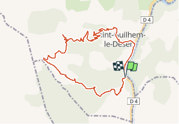
Tocht Stappen van 11,7 km beschikbaar op Occitanië, Hérault, Saint-Guilhem-le-Désert. Deze tocht wordt voorgesteld door jdelettrez.

Beschrijving

Maison forestiere des plos

Hoogteprofiel

Plaatsbepaling

Land:
France
Regio :
Occitanië
Departement/Provincie :
Hérault
Gemeente :
Saint-Guilhem-le-Désert
Locatie:
Unknown
Vertrek:(Dec)
Vertrek:(UTM)
544340 ; 4841402 (31T) N.

Opmerkingen

Gelieve in te loggen om een commentaar of een beoordeling achter te laten


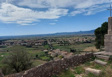
beau parcours avec des très belles vues sur la vallée de l Hérault puis la mer et le Canigou pour ma première sortie avec sitytrail j ai bien suivi la trace! merci


Wandeltochten in de omgeving

Tocht Stappen Aniane - Aniane ruisseau des Corbières - Photo
Stappen
kephas

Stappen

Gemakkelijk
(3)
Aniane, Occitanië, Hérault, France
9,5 km | 12 km-effort
2h 34min
Ja
Tocht Stappen Saint-Jean-de-Fos - St Jean de fos Les Plos - Photo
Stappen
mrclic34

Stappen

Gemakkelijk
(3)
Saint-Jean-de-Fos, Occitanië, Hérault, France
11 km | 15,2 km-effort
3h 5min
Ja
Tocht Stappen Montpeyroux - château de castelas - Photo
Stappen
mrclic34

Stappen

Gemakkelijk
(3)
Montpeyroux, Occitanië, Hérault, France
10,3 km | 15,1 km-effort
3h 12min
Ja
Tocht Stappen Montpeyroux - Saint baudille - Photo
Stappen
yt34

Stappen

Gemakkelijk
(3)
Montpeyroux, Occitanië, Hérault, France
10,2 km | 16,2 km-effort
3h 22min
Ja
Tocht Stappen Saint-Guilhem-le-Désert - Herault - St-Guilhem-le-Desert le Roc de la Vigne depuis le barrage 12km 609m - Photo
Stappen
RandoVal

Stappen

Medium
(1)
Saint-Guilhem-le-Désert, Occitanië, Hérault, France
12,1 km | 21 km-effort
4h 17min
Ja
Tocht Stappen Saint-Jean-de-Fos - St Jean de Fos et le Max Nègre - Photo
Stappen
GUIDE
randotines

Stappen

Medium
Saint-Jean-de-Fos, Occitanië, Hérault, France
19,1 km | 27 km-effort
5h 42min
Ja
Tocht Stappen Puéchabon - Causse Puechabon - Photo
Stappen
dpop34

Stappen

Heel gemakkelijk
(1)
Puéchabon, Occitanië, Hérault, France
12,8 km | 15,9 km-effort
Onbekend
Ja
Tocht Stappen Saint-Guilhem-le-Désert - St Guilhem Le Désert - Mas Aubert - Photo
Stappen
tracegps

Stappen

Moeilijk
(1)
Saint-Guilhem-le-Désert, Occitanië, Hérault, France
19,7 km | 30 km-effort
6h 30min
Ja
Tocht Stappen Montpeyroux - Le bary Arboras le Castelas - Photo
Stappen
labarone

Stappen

Gemakkelijk
Montpeyroux, Occitanië, Hérault, France
11,8 km | 17,1 km-effort
5h 7min
Ja


Sluiten
Mijn abonnementen