Tocht Paardrijden Les Salces - Boucle Complète Pâturages d'Aubrac 73 km - Photo

Boucle Complète Pâturages d'Aubrac 73 km

 Lozère Cheval
Lozère Cheval

Gebruiker

© OpenStreetMap contributors
Lengte
Lengte
73 km
Max. hoogte
Max. hoogte
1462 m
Positief hoogteverschil
1588 m
Km-Effort
Km-Effort  
94 km
Min. hoogte
Min. hoogte
1118 m
Negatief hoogteverschil
1639 m
Boucle
Boucle
Neen
Datum van aanmaak :
2020-04-09 14:17:17.343
Laatste wijziging :
2020-04-09 14:18:37.268

(0 Bericht)

Paardrijden
Paardrijden
11h42
Moeilijkheid : Zeer moeilijk

Scan deze QR-code om de tocht te openen in de SityTrail-applicatie

Gratisgps-wandelapplicatie

Logo SityTrail SityTrail

IGN / Geografische instituten

SityTrail uit de App Store downloaden SityTrail uit Google Play downloaden

Logo SityTrail SityTrail World

De wereld gaat voor u open

SityTrail uit de App Store downloaden SityTrail uit Google Play downloaden SityTrail op Huawei AppGallery downloaden

Over ons

Tocht Paardrijden van 73 km beschikbaar op Occitanië, Lozère, Les Salces. Deze tocht wordt voorgesteld door Lozère Cheval.

Beschrijving

Avec les modifications de laurent Couve

Hoogteprofiel

Foto's

POI's

POI Prinsuéjols-Malbouzon - Château de la Baume - Photo
Lozère Cheval
PRINSUÉJOLS-MALBOUZON 
POI Saint-Laurent-de-Muret - Gite Communal - Photo
Lozère Cheval
SAINT-LAURENT-DE-MURET 
POI Nasbinals - La Borie de l'Aubrac - Photo
Lozère Cheval
POI Nasbinals - Gite Equestre - Photo
Lozère Cheval
NASBINALS 
POI Trélans - Gites de Plagnes (Logis des Fées, Galabert ) - Photo
Lozère Cheval

Plaatsbepaling

Land:
France
Regio :
Occitanië
Departement/Provincie :
Lozère
Gemeente :
Les Salces
Locatie:
Unknown
Vertrek:(UTM)
505229 ; 4935918 (31T) N.

Wandeltochten in de omgeving

Tocht Stappen Les Hermaux - Rando Lozère.. Rajas..Malailhebiai. - Photo
Stappen
boubou68

Stappen

Zeer moeilijk
Les Hermaux, Occitanië, Lozère, France
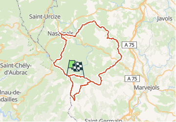
20 km | 26 km-effort
4h 4min
Ja
Tocht Stappen Nasbinals - Montorzier Croix de Vaysse Croix de Rodes - Photo
Stappen
GUIDE
antignacs

Stappen

Gemakkelijk
Nasbinals, Occitanië, Lozère, France
15,4 km | 19,6 km-effort
4h 13min
Ja
Tocht Noords wandelen Prades-d'Aubrac - SityTrail - Sentier thématique de Brameloup - Photo
Noords wandelen
mdauzat

Noords wandelen

Heel gemakkelijk
(1)
Prades-d'Aubrac, Occitanië, Aveyron, France
7,8 km | 10,5 km-effort
2h 0min
Ja
Tocht Sneeuwschoenen Saint-Chély-d'Aubrac - Tourbière alte teste rodes  - Photo
Sneeuwschoenen
GUIDE
antignacs

Sneeuwschoenen

Gemakkelijk
Saint-Chély-d'Aubrac, Occitanië, Aveyron, France
9,9 km | 12,7 km-effort
Onbekend
Ja
Tocht Stappen Nasbinals - Tourbiere salhens maillebiau rodes  - Photo
Stappen
GUIDE
antignacs

Stappen

Medium
Nasbinals, Occitanië, Lozère, France
21 km | 26 km-effort
6h 14min
Ja
Tocht Stappen Les Salces - Autour de maillebiau bonnecombes rajas - Photo
Stappen
GUIDE
antignacs

Stappen

Medium
Les Salces, Occitanië, Lozère, France
17,1 km | 22 km-effort
4h 23min
Ja
Tocht Stappen Marchastel - cap combattut  - Photo
Stappen
yt34

Stappen

Gemakkelijk
Marchastel, Occitanië, Lozère, France
7,2 km | 8,7 km-effort
2h 50min
Neen
Tocht Stappen Les Salces - Tour des Monts d'Aubrac - Du refuge des Rajas à Nasbinals - Photo
Stappen
tracegps

Stappen

Medium
Les Salces, Occitanië, Lozère, France
22 km | 28 km-effort
5h 30min
Neen
Tocht Stappen Les Hermaux - Signal de Mailhebiau - Photo
Stappen
gourdon

Stappen

Medium
Les Hermaux, Occitanië, Lozère, France
21 km | 27 km-effort
4h 45min
Ja


Sluiten
Mijn abonnementen