Tocht Mountainbike Dorénaz - Dorénaz - Sorniot -Dorénaz - Photo

Dorénaz - Sorniot -Dorénaz

 jokef
jokef

Gebruiker

© OpenStreetMap contributors
Lengte
Lengte
39 km
Max. hoogte
Max. hoogte
2327 m
Positief hoogteverschil
2261 m
Km-Effort
Km-Effort  
69 km
Min. hoogte
Min. hoogte
448 m
Negatief hoogteverschil
2262 m
Boucle
Boucle
Ja
Datum van aanmaak :
2014-12-11 00:00:00.0
Laatste wijziging :
2014-12-11 00:00:00.0

(0 Bericht)

Mountainbike
Mountainbike
5h00
Moeilijkheid : Onbekend

Scan deze QR-code om de tocht te openen in de SityTrail-applicatie

Gratisgps-wandelapplicatie

Logo SityTrail SityTrail

IGN / Geografische instituten

SityTrail uit de App Store downloaden SityTrail uit Google Play downloaden

Logo SityTrail SityTrail World

De wereld gaat voor u open

SityTrail uit de App Store downloaden SityTrail uit Google Play downloaden SityTrail op Huawei AppGallery downloaden

Over ons

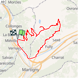
Tocht Mountainbike van 39 km beschikbaar op Valais/Wallis, Saint-Maurice, Dorénaz. Deze tocht wordt voorgesteld door jokef.

Beschrijving

Montée en cabine depuis Dorénaz. La route goudronnée est sans intérêt et on gagne une bonne heure de grimpette.

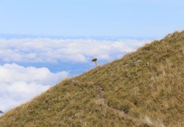
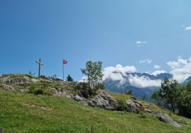
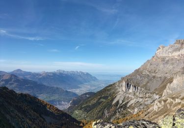
Suivre la route jusqu''à la cabane de Scex Carro pour attraper le chemin à flanc de coteau environ 200m plus haut à gauche. Prendre direction cabane du Demècre, puis direction Portail de Fully. Attention, ça gaze un peu sur le sentier sous le Portail en direction du col de Sorniot. Chute interdite et petit bout à pied conseillé. Idem sous le Chavalard, en direction de l''Erie. Le sentier est de toute beauté avec une vue splendide sur la plaine, mais si vous avez le vertige, ça ne va pas le faire. Attention aussi aux marcheurs qui peuvent être nombreux.

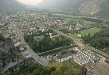
Descente sur Fully par les sentiers du coteau et retour sur Dorénaz en rive gauche.

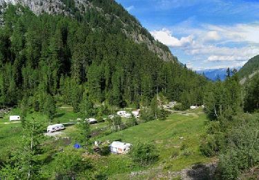
Plus facilement faisable en deux jours avec une nuit à la cabane de Sorniot (www.chavalard.com).

Hoogteprofiel

Plaatsbepaling

Land:
Switzerland
Regio :
Valais/Wallis
Departement/Provincie :
Saint-Maurice
Gemeente :
Dorénaz
Locatie:
Unknown
Vertrek:(Dec)
Vertrek:(UTM)
348984 ; 5112612 (32T) N.

Wandeltochten in de omgeving

Tocht Te voet Martigny - Géoglyphe de Grande Tête - Photo
Te voet
PRO

Te voet

Gemakkelijk
Martigny, Valais/Wallis, Martigny, Switzerland
3,8 km | 4,5 km-effort
1h 0min
Neen
Tocht Te voet Evionnaz - Chemin pédestre, région Martigny - Photo
Te voet
PRO

Te voet

Gemakkelijk
Evionnaz, Valais/Wallis, Saint-Maurice, Switzerland
14,3 km | 17,1 km-effort
3h 52min
Neen
Tocht Te voet Salvan - Tour du Vallon de Van - Photo
Te voet
PRO

Te voet

Gemakkelijk
Salvan, Valais/Wallis, Saint-Maurice, Switzerland
6,7 km | 11,3 km-effort
2h 34min
Ja
Tocht Te voet Saint-Maurice - Tour des Dents du Midi - Photo
Te voet
PRO

Te voet

Zeer moeilijk
Saint-Maurice, Valais/Wallis, Saint-Maurice, Switzerland
46 km | 88 km-effort
19h 58min
Ja
Tocht Stappen Saint-Maurice - Tour des dents du midi - Photo
Stappen
GhiJoe

Stappen

Medium
Saint-Maurice, Valais/Wallis, Saint-Maurice, Switzerland
59 km | 107 km-effort
23h 39min
Ja
Tocht Stappen Dorénaz - le Diabley  - Photo
Stappen
reneperrin

Stappen

Medium
Dorénaz, Valais/Wallis, Saint-Maurice, Switzerland
13,3 km | 31 km-effort
4h 36min
Ja
Tocht Stappen Salvan - Les gorges à Martigny - Photo
Stappen
thierry.berthouze

Stappen

Moeilijk
Salvan, Valais/Wallis, Saint-Maurice, Switzerland
10,5 km | 17,7 km-effort
2h 34min
Neen
Tocht Stappen Salvan - Sentier Nature - Rochers du Soir - Photo
Stappen
GUIDE+

Stappen

Heel gemakkelijk
Salvan, Valais/Wallis, Saint-Maurice, Switzerland
3,6 km | 6 km-effort
Onbekend
Ja
Tocht Stappen Saint-Maurice - Abenteuer-Trek in ein unbekanntes Wallis. Mex - Salanfe (Hotel) - Photo
Stappen
GUIDE+

Stappen

Heel gemakkelijk
Saint-Maurice, Valais/Wallis, Saint-Maurice, Switzerland
9,4 km | 23 km-effort
Onbekend
Neen


Sluiten
Mijn abonnementen