Tocht Stappen Valady - Valady nuces serres  - Photo

Valady nuces serres

 ZITO12
ZITO12

Gebruiker

© OpenStreetMap contributors
Lengte
Lengte
12,6 km
Max. hoogte
Max. hoogte
513 m
Positief hoogteverschil
320 m
Km-Effort
Km-Effort  
16,9 km
Min. hoogte
Min. hoogte
320 m
Negatief hoogteverschil
329 m
Boucle
Boucle
Neen
Datum van aanmaak :
2020-05-28 07:40:04.83
Laatste wijziging :
2021-03-13 10:00:47.236

(0 Bericht)

Stappen
Stappen
4h07
Moeilijkheid : Gemakkelijk

Scan deze QR-code om de tocht te openen in de SityTrail-applicatie

Gratisgps-wandelapplicatie

Logo SityTrail SityTrail

IGN / Geografische instituten

SityTrail uit de App Store downloaden SityTrail uit Google Play downloaden

Logo SityTrail SityTrail World

De wereld gaat voor u open

SityTrail uit de App Store downloaden SityTrail uit Google Play downloaden SityTrail op Huawei AppGallery downloaden

Over ons

Tocht Stappen van 12,6 km beschikbaar op Occitanië, Aveyron, Valady. Deze tocht wordt voorgesteld door ZITO12.

Beschrijving

Attention, au point Km 3 l'aller retour à la cote 509 est barré par un panneau d'interdiction pour cause de propriété privé.

Hoogteprofiel

Foto's

Plaatsbepaling

Land:
France
Regio :
Occitanië
Departement/Provincie :
Aveyron
Gemeente :
Valady
Locatie:
Unknown
Vertrek:(UTM)
454496 ; 4922750 (31T) N.

Wandeltochten in de omgeving

Tocht Stappen Clairvaux-d'Aveyron - Clairvaux les vignes  - Photo
Stappen
ZITO12

Stappen

Medium
Clairvaux-d'Aveyron, Occitanië, Aveyron, France
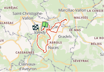
11,7 km | 17,7 km-effort
3h 34min
Ja
Tocht Te voet Marcillac-Vallon - De la Vigne à la Forêt - Photo
Te voet
PRO

Te voet

Gemakkelijk
Marcillac-Vallon, Occitanië, Aveyron, France
10,1 km | 14,1 km-effort
3h 11min
Ja
Tocht Te voet Clairvaux-d'Aveyron - Le Puech du Puot - Photo
Te voet
PRO

Te voet

Gemakkelijk
Clairvaux-d'Aveyron, Occitanië, Aveyron, France
11,3 km | 16 km-effort
3h 38min
Neen
Tocht Te voet Marcillac-Vallon - Le Puech du Cayla - Photo
Te voet
PRO

Te voet

Gemakkelijk
Marcillac-Vallon, Occitanië, Aveyron, France
5,5 km | 7,9 km-effort
1h 47min
Neen
Tocht Te voet Valady - Des Vignes aux Moulins - Photo
Te voet
PRO

Te voet

Gemakkelijk
Valady, Occitanië, Aveyron, France
11,3 km | 15,2 km-effort
3h 26min
Ja
Tocht Stappen Saint-Christophe-Vallon - Le Puech du Cayla  - Photo
Stappen
ZITO12

Stappen

Heel gemakkelijk
Saint-Christophe-Vallon, Occitanië, Aveyron, France
11,5 km | 15,7 km-effort
4h 59min
Ja
Tocht Stappen Goutrens - Autour de Goutrens - Photo
Stappen
tracegps

Stappen

Medium
Goutrens, Occitanië, Aveyron, France
11,7 km | 15,2 km-effort
3h 15min
Ja
Tocht Stappen Clairvaux-d'Aveyron - Autour de Panat - Photo
Stappen
tracegps

Stappen

Medium
Clairvaux-d'Aveyron, Occitanië, Aveyron, France
10,9 km | 15,4 km-effort
3h 15min
Ja
Tocht Stappen Goutrens - Goutrens - Photo
Stappen
ZITO12

Stappen

Heel gemakkelijk
Goutrens, Occitanië, Aveyron, France
12,1 km | 15,6 km-effort
4h 28min
Ja


Sluiten
Mijn abonnementen